• Welcome to TalkWeather!
    We see you lurking around TalkWeather! Take the extra step and join us today to view attachments, see less ads and maybe even join the discussion.
    CLICK TO JOIN TALKWEATHER

Severe Weather Threat 4/28-4/30

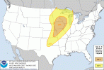
KDMX (Des Moines) statement on Monday so far:

"The large parent storm system will then finally approach and move over Iowa Monday
and Monday night. Temperatures will be notably warmer on Monday,
pushing up into the 80s across most of our forecast area while
dewpoints surge into the 60s. The robust wind fields ahead of the
approaching cyclone, along with strong instability resulting from
the low- level warm air/moisture advection, will create a favorable
parameter space for organized thunderstorms and potentially
supercells within this broad region. However, many of the global
models and ensembles have been struggling to depict a corresponding
coverage or intensity of convection. Questions remain as to where
the highest threat will materialize, how much convection will occur
in the warm sector versus on the advancing/trailing cold front, and
how the details of this scenario will shake out. SPC has indicated
an enhanced severe weather risk across Iowa on Monday and we will be
closely monitoring this potential over the next several days."
 
Very large 30% and 15% areas for the latest SPC outlook, including the mention of strong tornadoes.
1000079480.gif1000079481.gif


...DISCUSSION...
...Day 4/Mon - Southern Plains to Upper Midwest...
A strong mid-level jet streak will move rapidly northeastward from
the Southwest to the Upper Midwest on Monday. As this occurs, a
surface low will deepen and move from the northern Plains to the
northern Great Lakes. Strong southwesterly lower tropospheric flow
will advect high theta-e air northward across the Midwest and into
parts of the Upper Midwest. Broken to scattered cloudcover will
support surface heating and strong destabilization across the warm
sector from southeast Minnesota and western Wisconsin to the
southern Plains. Isolated to scattered supercells are likely along
the dryline which will extend from the southern Plains and into
Kansas.

The greatest focus for severe weather on Monday will be from eastern
Kansas into northern Missouri, much of Iowa and into southern
Minnesota and western Wisconsin. Moderate to strong instability,
strong shear, and increasing forcing for ascent supports the
potential for numerous rounds of severe thunderstorms. The wind
profile supports supercells capable of all severe weather hazards
including the potential for strong tornadoes.

...Day 5/Tue - Southern Plains to parts of the Northeast...
The surface low associated with the Day 4 threat will continue
northeast and bring its associated cold front eastward across the
Midwest and Great Lakes through the day Tuesday. Moderate to strong
instability is forecast south of this front from northern New York
to the Ohio Valley. Much of the frontal zone should have sufficient
shear to support multiple storm clusters and the potential for a few supercells.
 
Model soundings from all the main globals continues to suggest an environment easily supportive of EF3+ tornadoes will set up across parts of the upper Midwest on Monday. GFS and GEM aren’t quite to the same extent as ECM, ICON and UKMET, but even then would be a significant tornado threat.

IMG_8298.pngIMG_8302.png
IMG_8300.pngIMG_8301.png

It’s early days, still, but I suspect the extent and magnitude of any severe risk will largely depend on the trough shape and ejection - with which model uncertainty is still somewhat high. Though even if it’s going to be just one or two supercells, as opposed to multiple, that will still pose trouble. Needs close watching and let’s hope things tune down at least a little!
 
Model soundings from all the main globals continues to suggest an environment easily supportive of EF3+ tornadoes will set up across parts of the upper Midwest on Monday. GFS and GEM aren’t quite to the same extent as ECM, ICON and UKMET, but even then would be a significant tornado threat.

View attachment 40313View attachment 40317
View attachment 40315View attachment 40316

It’s early days, still, but I suspect the extent and magnitude of any severe risk will largely depend on the trough shape and ejection - with which model uncertainty is still somewhat high. Though even if it’s going to be just one or two supercells, as opposed to multiple, that will still pose trouble. Needs close watching and let’s hope things tune down at least a little!
Where's that UKMET sounding taken from?
 
I did a bit of dissecting into the Greenfield Tornado from last year thanks to Convective Chronicles, and honestly, this 4/28 setup resembles a lot of the same characteristics as last years outbreak, showing that anything can happen. However, one could argue that Greenfield was a semi-unicorn event in terms of kinematics not being the whole story.
 
Quite a bit of capping there around 850mb
Yeah, thats what I really don't like.

If this were to verify, there is enough shear and helicity for intense tornadoes and the capping would prevent overconvection. Mix that with the 2000-2500 J/kg of CAPE, decent lapse rates, the hodograph, moisture, 3CAPE, and more, then you have an environment for strong to intense tornadoes. Also, with the capping in play, I don't know if I buy it being a squall line.
The problem I am seeing right now is the area with the best helicity has the worst thermo's and vice versa, and theres still a pretty strong cap in place along the dryline at 0z on the NAM. I am not saying it won't happen, theres a lot of time for the details to line up with the big picture setup there, but VERBATIM what the models are showing does not scream major outbreak to me.

Near Iowa/MN border where the best shear is but poor thermos:

1745595005933.png


Along the dryline in north central OK with impressive cape but less than impressive low level shear:

1745595116584.png

I would still be concerned about any strorms that can initiate in kansas on Sunday night as the LLJ really ramps up after dark with a pretty impressive although capped environment.
 
Yeah, thats what I really don't like.

If this were to verify, there is enough shear and helicity for intense tornadoes and the capping would prevent overconvection. Mix that with the 2000-2500 J/kg of CAPE, decent lapse rates, the hodograph, moisture, 3CAPE, and more, then you have an environment for strong to intense tornadoes. Also, with the capping in play, I don't know if I buy it being a squall line.
1000079484.png

Adding on to it, this is north central Iowa. Hodograph that screams strong tornado potential. Stout CINH numbers as well that could make this a discrete setup. More than enough SRH numbers. Definitely looking like a significant severe weather episode. Question remains does the cap break *enough* for storms to develop. If so, they should remain discrete.
 
View attachment 40321

Adding on to it, this is north central Iowa. Hodograph that screams strong tornado potential. Stout CINH numbers as well that could make this a discrete setup. Definitely more than enough SRH numbers. Definitely looking like a significant severe weather episode. Question remains does the cap break *enough* for storms to develop. If so, they should remain discrete.

Yeah, we might even have a long tracker or two in an environment like this. I'm waiting for the HRRR to really start saying intense, long tracked tornadoes are possible. But I think it's time to start calling this a significant setup with a semi-low floor and high ceiling.

Are we looking at a possible day 2 or 3 MDT?
Day 2 I would give about 65% chance as of right now. Don't think we see one tomorrow, but if I had to put a percentage chance, probably a 20-25%.
 
Back
Top