
CheeselandSkies
Member
Moderate kept at 01Z in a slightly smaller area, but the wording doesn't sound very confident.
Ninja'd by @TheSuckZone
Ninja'd by @TheSuckZone
Follow along with the video below to see how to install our site as a web app on your home screen.
Note: This feature may not be available in some browsers.

New MCD issued for the three storms heading into Paducah's CWA.Mesoscale Discussion 0584
NWS Storm Prediction Center Norman OK
0810 PM CDT Mon Apr 27 2026
Areas affected...Southern and southeast Missouri
Concerning...Tornado Watch 160...162...
Valid 280110Z - 280315Z
The severe weather threat for Tornado Watch 160, 162 continues.
SUMMARY...The tornado potential appears to be increasing across
south-central to southeast Missouri as a trio of supercells migrate
into a strongly sheared environment.
DISCUSSION...Recent GOES IR imagery has show steady intensification
of a trio of supercells across southern MO over the past 30 minutes
as convection begins to migrate into an axis of very high (3000-4000
J/kg) MLCAPE. Although regional radars are primarily sampling the
mid-levels of the storms, organizing/intensifying mesocyclones have
also been noted. While it remains somewhat unclear whether or not
these cells have become surface based (a weak outflow boundary was
noted earlier upstream closer to KSGF), these observations point
towards steady intensification.
Downstream, regional VWPs are sampling ample 0-1 km SRH on the order
of 350 m2/s2. The combination of strong low-level shear and very
high buoyancy is supporting a plume of STP values between 4-6
downstream into southeast MO. The approaching cells will have long
residence time within this environment, which should continue to
favor intensification and an increasing tornado threat - including
the potential for significant tornadoes - if cells currently are, or
can soon become, rooted near the surface.
I'm sorry, but for right now...main show starting to pop off. this thing about to go postal.

I’m truly getting sick of your hyperbolic postsmain show starting to pop off. this thing about to go postal.
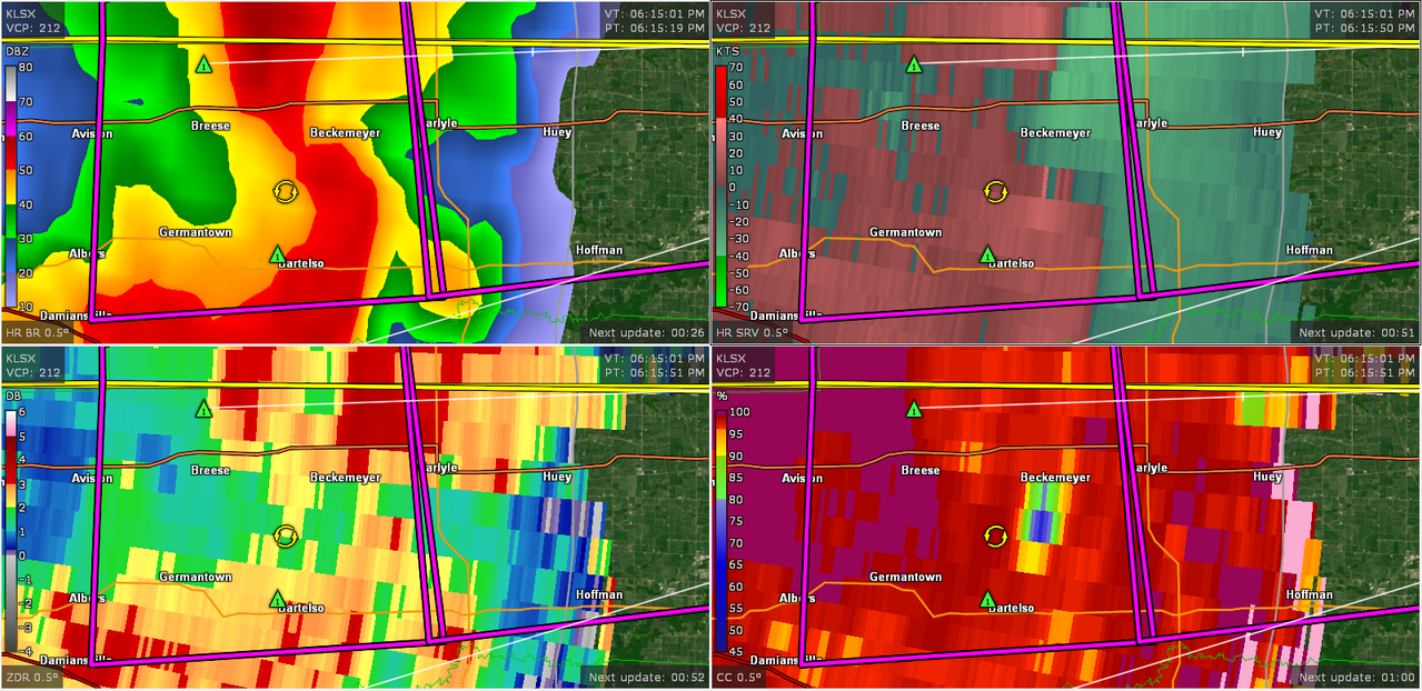
Stop it. You need to stop being so hyperbolic.life threatening situation for carlyle IL. incredibly tight couplet due ssw. yikes.
may be you let the NWS know that PDS warning wasn’t necessary. kthx.Stop it. You need to stop being so hyperbolic.