AJS
Member
Alabama cell still looks worrying. Couplet is beginning to tighten up a bit and a slight TDS remains.
Follow along with the video below to see how to install our site as a web app on your home screen.
Note: This feature may not be available in some browsers.

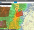
It's showing 1000-2000 CAPE in Northern Alabama... Also looks like there's a gap where most of the supercells are right now

Out of curiosity, what website/program are you using to get those kinds of screenshots?Showing my age with the old school nexrad shot, but no doubt where that one is.
View attachment 36266
Was looking at that one, wondering if it's gunna wrap upFayette storm has had a remarkable increase in lightning


I love the old school display. Much easier to pinpoint for me.Showing my age with the old school nexrad shot, but no doubt where that one is.
so no OWS developmentBoth mesoscale and model data suggest that the highest threat in the coming hours will be across west-central, southern and then central Alabama from these clusters of storms and confluence bands in MS. Most dangerous storms will likely originate there and propogate northeastward. Wouldn't be surprised if some of the activity, including the AL cell now, puts down some boundaries.
View attachment 36269View attachment 36270

A bunch of towns in the path too.Tuscaloosa cell is nuts right now

No. WS development will be focused along a corridor starting in SW and W-Central AL and then spread northeast.so no OWS development