Bama Ravens
Member
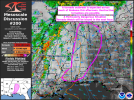
The couplet on lead storm near Isola, MS looks to have weakened a good bit. Hopefully it’s no longer producing a tornado.
Follow along with the video below to see how to install our site as a web app on your home screen.
Note: This feature may not be available in some browsers.
That may be true, but as that line of storms continues to move east, you’re going to need the right spacing and orientation for those cells to not only form, but have the space & time to move off and actually get a chance to mature. With that rain mass, it’s really going to put pressure on the cells to develop and move out and away from it quickly.Given that this event still has 6-8 hours left, plenty of time for that development to occur, especially as E MS/W AL continues to warm throughout the day
I think that’ll be the last of that storm, you’ll have have to worry about straight line winds. Which should be taken seriously as much as a tornado.The couplet on lead storm near Isola, MS looks to have weakened a good bit. Hopefully it’s no longer producing a tornado.
but why? what makes you think the HRRR had a good grip on things 48-60 hours out but is out to lunch within 6-12 hours?Hrrr looks just convection for Birmingham! I don’t buy that one bit
Quiet, sunny and a balmy 76° in Moody, AL just east of BirminghamI think Alabama is where you’ll really start seeing things get violent. It’s eerily quiet there.
IMO, the HRRR has had a good handle so far.but why? what makes you think the HRRR had a good grip on things 48-60 hours out but is out to lunch within 6-12 hours?
So it was on ground,…Storm Report: houses damaged with possible injuries in Grace, MS from the first couplet.
but why? what makes you think the HRRR had a good grip on things 48-60 hours out but is out to lunch within 6-12 hours?
I would say more eastward into Georgia. Your atmosphere has really been worked over with all the rain, Atlanta is wide open. 73 degrees and climbing.I'm really curious to see if they expand the MDT/High into Mid TN or if they stretch it across the eastern side of AL.
Definitely looks like some of the storms may be becoming discrete.That's a lot of prefrontals... Hoping they congeal and turn linear pretty quickly but it seems like they're going to stay semi-discrete at least.