hurricaneguy
Member
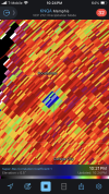
Stove pipe tornado live on Ryan Hall! MS storm. Yikes!
Follow along with the video below to see how to install our site as a web app on your home screen.
Note: This feature may not be available in some browsers.


Severe Weather Statement
National Weather Service Jackson MS
1122 PM CDT Fri Mar 14 2025
MSC015-051-053-083-133-150515-
/O.CON.KJAN.TO.W.0037.000000T0000Z-250315T0515Z/
Sunflower MS-Holmes MS-Carroll MS-Leflore MS-Humphreys MS-
1122 PM CDT Fri Mar 14 2025
...A TORNADO WARNING REMAINS IN EFFECT UNTIL 1215 AM CDT FOR
SOUTHEASTERN SUNFLOWER...NORTHWESTERN HOLMES...WEST CENTRAL
CARROLL...LEFLORE AND NORTHEASTERN HUMPHREYS COUNTIES...
At 1122 PM CDT, a confirmed large and extremely dangerous tornado was
located near Swiftown, or 10 miles north of Belzoni, moving northeast
at 45 mph.
This is a PARTICULARLY DANGEROUS SITUATION. TAKE COVER NOW!
HAZARD...Damaging tornado.
SOURCE...Weather spotters confirmed tornado.
IMPACT...You are in a life-threatening situation. Flying debris may
be deadly to those caught without shelter. Mobile homes
will be destroyed. Considerable damage to homes,
businesses, and vehicles is likely and complete destruction
is possible.
The tornado will be near...
Morgan City, Moorhead, Quito, and Itta Bena around 1130 PM CDT.
Greenwood around 1140 PM CDT.
Schlater around 1150 PM CDT.
PRECAUTIONARY/PREPAREDNESS ACTIONS...
To repeat, a large, extremely dangerous and potentially deadly
tornado is on the ground. To protect your life, TAKE COVER NOW! Move
to a basement or an interior room on the lowest floor of a sturdy
building. Avoid windows. If you are outdoors, in a mobile home, or in
a vehicle, move to the closest substantial shelter and protect
yourself from flying debris.
&&
LAT...LON 3341 8994 3318 9049 3328 9062 3371 9035
TIME...MOT...LOC 0422Z 220DEG 38KT 3333 9049
TORNADO...OBSERVED
TORNADO DAMAGE THREAT...CONSIDERABLE
MAX HAIL SIZE...1.50 IN


It's showing as confirmed on GRLevel3.Unconfirmed violent tornado about to strike Jacksonport AR!!!
View attachment 35910
TDS is only getting larger. Clearly hit something substantial.Large unconfirmed tornado near Newport AR!
View attachment 35908