• Welcome to TalkWeather!
    We see you lurking around TalkWeather! Take the extra step and join us today to view attachments, see less ads and maybe even join the discussion.
    CLICK TO JOIN TALKWEATHER

Severe WX Severe Weather Threat 3/14-3/16

I'm not sure y'all are understand how bad tommrow afternoon could be. We have a highly favorable tornadic enviroment, with atleast 5+ tornadic storms it looks like going at one time based off the HRRR. Tommrow we very well could have a hard time tracking them all because there's so many producing tornadoes. I highly suspect a 45% tornado risk will come for the border of Alabama and Mississippi.

Given the sheer amount of posts gaping in awe at some of the CAMS runs and posts by the mets on the board, I think most folks here are fully aware of the ceiling for tomorrow
 
I'm not sure y'all are understand how bad tommrow afternoon could be. We have a highly favorable tornadic enviroment, with atleast 5+ tornadic storms it looks like going at one time based off the HRRR. Tommrow we very well could have a hard time tracking them all because there's so many producing tornadoes. I highly suspect a 45% tornado risk will come for the border of Alabama and Mississippi.
My friends family is in Huntsville. Gave her heads up.
 
Probably not the best place to ask this but I'm not sure where else to ask: With all of the focus being on (understandably) tomorrow, does anybody know of some meteorologists that are along the I44 corridor that'll be talking about and covering this evening live? Rolla is a dead spot in terms of radar coverage so I'm making sure all of my bases are covered.
 
ADMIN NOTE
For this event, we have enabled additional filtering. This will prompt you if your reply is too short or if you are trying to reply with images. Remember that the reaction icons are a great way to express your thoughts on a post and will help keep the conversation flowing smoothly. Also, we have Discord on the way; it's not quite ready for this event, but it will be available soon.
 

High Risk Of Severe Weather Now Issued For Saturday!

Jack Rudden | March 14, 2025 @ 12:41 pm


In the latest update from SPC, an extremely rare HIGH RISK (level 5/5) of severe weather has been issued for the anticipated severe weather outbreak on Saturday. This is only the 3rd ever day 2 high risk issued anywhere in the country. This will be a high impact and volatile severe weather outbreak. Please continue to prepare accordingly by ensuring you have multiple ways to receive warnings and a designated shelter in mind.


Category: Alabama's Weather, ALL POSTS, Social Media
 
I just looked at the weather data for Missouri, and right now it's mostly ambient temperatures in the 70s-80s and dewpoint temperatures in the 30s-40s (a substantial dewpoint spread), which suggests that the current storms will be fairly elevated for a while until the main moisture mass reaches the area (which could happen sometime in the next several hours).
 
I will go on record to formally state that the placement of the northern edge of the current HIGH is not only dangerously wrong, but it will cause fatalities tomorrow... and I don't care who is mad or offended by my saying so. I am already seeing a significant number of general public comments of "I'm not in the pink. No threat here." and they are tuning out. Some of them are tuning out for the duration because they actually believe that just because they aren't in the 3rd ever Day 2 HIGH in recorded United States history at this moment, that they are not at any threat. They won't be tuned back in when the data forces the SPC forecasters on duty to wake up to the reality of the actual placement of the outbreak and expand the HIGH northward. Unless the NSSL WRF was followed blindly, there was an overwhelming data signal this morning to pull the HIGH all the way to the state line for the northern border. Even the HREF probabilistic guidance that includes that NSSL WRF run has steadily focused north and northwest of the HIGH. I believe the southern extent of it is perfectly fine and needed, but that thing needs to include Tupelo, Iuka, the Shoals, Athens, Cullman, Hamilton, Decatur, Huntsville, and Ardmore... and there is still a signal for violent type tracks into southern middle TN.
 
I'm not sure y'all are understand how bad tommrow afternoon could be. We have a highly favorable tornadic enviroment, with atleast 5+ tornadic storms it looks like going at one time based off the HRRR. Tommrow we very well could have a hard time tracking them all because there's so many producing tornadoes. I highly suspect a 45% tornado risk will come for the border of Alabama and Mississippi.
Sounds a lot like 4/27. Tornadoes were dropping everywhere.
 
I will go on record to formally state that the placement of the northern edge of the current HIGH is not only dangerously wrong, but it will cause fatalities tomorrow... and I don't care who is mad or offended by my saying so. I am already seeing a significant number of general public comments of "I'm not in the pink. No threat here." and they are tuning out. Some of them are tuning out for the duration because they actually believe that just because they aren't in the 3rd ever Day 2 HIGH in recorded United States history at this moment, that they are not at any threat. They won't be tuned back in when the data forces the SPC forecasters on duty to wake up to the reality of the actual placement of the outbreak and expand the HIGH northward. Unless the NSSL WRF was followed blindly, there was an overwhelming data signal this morning to pull the HIGH all the way to the state line for the northern border. Even the HREF probabilistic guidance that includes that NSSL WRF run has steadily focused north and northwest of the HIGH. I believe the southern extent of it is perfectly fine and needed, but that thing needs to include Tupelo, Iuka, the Shoals, Athens, Cullman, Hamilton, Decatur, Huntsville, and Ardmore... and there is still a signal for violent type tracks into southern middle TN.

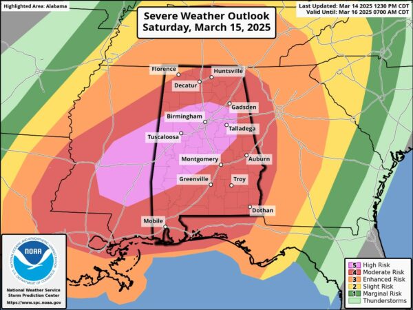
Absolutely agree. The fact they didn't put at least northwest Alabama in the high risk after almost every model run has been showing it having so much activity...I don't get it.
 
Absolutely agree. The fact they didn't put at least northwest Alabama in the high risk after almost every model run has been showing it having so much activity...I don't get it.
It honestly leads me to believe that their Day 2 outlook is extremely conservative, which is incredibly worrying for what the Day 1 outlook will look like, and most importantly how bad tomorrow will end up being.
 
Back
Top