UpperLevelLOL
Member
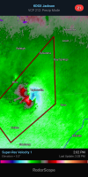
TORE incoming for Taylorsville
Follow along with the video below to see how to install our site as a web app on your home screen.
Note: This feature may not be available in some browsers.
Bay Springs, not Bassfield.Brad Arnold reports new tornado emergency about to be issues for Bassfield, MS
Yeah the strengthening low level jet is about to change all of thatThermodynamics expanding across the Deep South. Dews still lower in parts of AL, but RAP suggests that changes rapidly.
View attachment 36178View attachment 36179
This implies NW AL will be in the crosshairs by 5 PM CDT.
Thank you for correcting. I'm still learning the geography! (and apparently I can't type for anything...)Bay Springs, not Bassfield.

Yep. Helping them stay more discrete. I Think it could be from the upper level support finally arriving and shifting the deep layer vectors more to a 45 degree angle vs that northern motion earlierNot a huge shift but it does seem like some of them are moving more NE than NNE.
can you see it now?