
We'll see. They should but they've been notoriously stingy with that designation in the past.Yeah, I think it's a matter of when and not if now
Navigation
Install the app
How to install the app on iOS
Follow along with the video below to see how to install our site as a web app on your home screen.
Note: This feature may not be available in some browsers.
More options
-
Welcome to TalkWeather! We see you lurking around TalkWeather! Take the extra step and join us today to view attachments, see less ads and maybe even join the discussion. CLICK TO JOIN TALKWEATHER
You are using an out of date browser. It may not display this or other websites correctly.
You should upgrade or use an alternative browser.
You should upgrade or use an alternative browser.
Severe WX Severe Weather Threat 3/14-3/16
- Thread starter Bulkshear
- Start date
So far it looks like the early Saturday morning convection on the 18z HRRR doesn't have much of an impact on atmospheric recovery.
EDIT: Yeah, it clears out and moves northward quickly enough just around 14z for CAPE values to begin rapidly increasing. Morning convection really might not be an issue.
EDIT: Yeah, it clears out and moves northward quickly enough just around 14z for CAPE values to begin rapidly increasing. Morning convection really might not be an issue.
Equus
Member
Only two day two highs have been issued before (for 4/7/06 and 4/14/12) - always possible, but they've got to have exceptional confidence to do it before the D1
Cyclonic Paracosm
Member
yesssss, the mid day update for D3 is perfectionAlso, absolutely adore and appreciate that they're doing D3 updates now. For normal people I'm sure it doesn't matter at all but for weather geeks like us it's been really nice.
DetectiveWX
Member
Another thing to think about: the St Patrick's celebrations going on. Hope they're not turning a blind eye to this.
tornado examiner
Member
Can any post post the HRRR?


Cyclonic Paracosm
Member

send help
hurricaneguy
Member
Wild that 04/27/11 didnt have a high risk D2Only two day two highs have been issued before (for 4/7/06 and 4/14/12) - always possible, but they've got to have exceptional confidence to do it before the D1
UpperLevelLOL
Member
Latest HRRR uptrends moisture further north for tomorrow, I really think the tornado threat for KY/TN/Northern AL is getting slept on a bit
Cyclonic Paracosm
Member

I uh---

tornado examiner
Member
“Uh, its not looking good here Uh…”View attachment 35333
send help
lake.effect
Member
- Messages
- 751
- Reaction score
- 2,465
- Location
- Mississippi State University
- Special Affiliations
- SKYWARN® Volunteer
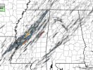
Just an insane depiction from the HRRR.

Cyclonic Paracosm
Member
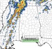
captain crunches oops all hooksRefl. loop.
View attachment 35335
- Admin
- #2,078
- Messages
- 2,425
- Reaction score
- 2,267
- Location
- Meridianville, Al
- Special Affiliations
- SKYWARN® Volunteer
The parade in downtown Huntsville for Saturday was canceled in the last couple of hours.Another thing to think about: the St Patrick's celebrations going on. Hope they're not turning a blind eye to this.
NAM seems to be the biggest offender as it often models high-capped environments with a high STP. HRRR tends to be more realistic and doesn't model the high capped areas with high STP as aggressively. I don't know if this is due to an underlying model architecture for producing higher STP values or if the HRRR is generally just less aggressive as a model.
I always get the sense systems like this weekend, while dreadful, contribute to an overall increased understanding and refinement of the forecasting tools we all rely on, and the atmospheric elements that lead to tornado genesis. For example, April 27th 2011 became a new measuring tool we can use to get a sense of how a storm will perform simply by how all its elements compare to that day.
