• Welcome to TalkWeather!
    We see you lurking around TalkWeather! Take the extra step and join us today to view attachments, see less ads and maybe even join the discussion.
    CLICK TO JOIN TALKWEATHER

Severe WX Severe Weather Thread - 6/15/26 - 6/18/26

This is why I do not want to pursue a career in meteorology. Imagine having to deal with this headache, except it's your entire job to be the voice of reason instead of being some random guy on a small forum not bearing any responsibilities.
I’ve always wanted to become a meteorologist, but then I turned 18 and realized it’s no different than what I do anyways which is sit in a chair and forecast, except you actually have lives in your hand and any mistake you make while forecasting have real life consequences.
 
I’ve always wanted to become a meteorologist, but then I turned 18 and realized it’s no different than what I do anyways which is sit in a chair and forecast, except you actually have lives in your hand and any mistake you make while forecasting have real life consequences.
Couldn't agree more. I sit here and think I'd want to be one but I think the backlash that you get from people who don't understand model data makes it not worth it. Backlash, "oh you got it wrong" "it's another overblown storm!"

The mental aspect I probably would get fed up with eventually.
 
Here's your cap. Neither the NAM or HRRR show this clearing out before the next line of storms, and that'll be the biggest fly in the ointment. The clearing over central Iowa is supposed to continue moving East and that'll be where storms eventually fire

1781710754809.png
 
Couldn't agree more. I sit here and think I'd want to be one but I think the backlash that you get from people who don't understand model data makes it not worth it. Backlash, "oh you got it wrong" "it's another overblown storm!"

The mental aspect I probably would get fed up with eventually.
If I were to become a meteorologist of some sort, I'd much prefer simply study and/or program tools than be a forecaster.
I wonder if I can actually get a programming job at the NWS without a meteorology degree.
 
If I were to become a meteorologist of some sort, I'd much prefer simply study and/or program tools than be a forecaster.
I wonder if I can actually get a programming job at the NWS without a meteorology degree.
Don’t think that’s possible. Computer programming is arguably the hardest sector of meteorology.
Not only do you have to do computer programming which is difficult in of itself, you have to have a profound understanding of atmospheric dynamics which includes an ungodly amount of calculus and derivatives so that you can incorporate that into either making your own site or update/upkeep the standard government weather models.

Edit: not saying you couldn’t do of course, just saying it’s not doable without having a degree.
 
Where I am at I am limited on the tools i can access. What is the LLJ doing and does anyone have an image of its current status?
 
Hodographs are becoming much larger and more favorable overtime based on the -4hr, -2hr and current hodograph map on mesoanalysis. LLJ is pushing in and quickly moving the MCS out of the way, which is probably why those hodographs are growing. It also appears that the center of low pressure is further east than forecasted.
 
Day 1 Convective Outlook
NWS Storm Prediction Center Norman OK
1128 AM CDT Wed Jun 17 2026

Valid 171630Z - 181200Z

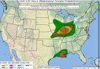
...THERE IS A MODERATE RISK OF SEVERE THUNDERSTORMS ACROSS PARTS OF
ILLINOIS AND INDIANA...

...THERE IS A SLIGHT RISK OF SEVERE THUNDERSTORMS TONIGHT OVER
SOUTHEAST LOUISIANA AND SOUTHERN MISSISSIPPI...

...SUMMARY...
Numerous severe thunderstorms are expected this afternoon into
tonight, with the peak threat centered over Illinois and Indiana.
Intense tornadoes, swaths of damaging gusts over 75 mph and damaging
wind-driven large hail will all be possible.

...MO/IL/IN...
An intense and fast-moving shortwave trough continues to approach
the Midwest today, with an associated 90+ knot mid level jet
streaking across the region. A very strong southerly low-level jet
precedes this trough, and has resulted in widespread thunderstorms
over central IL. The effects of this early convection will be
important to the mesoscale details of where the main risk of severe
storms will develop later today.

The primary outflow boundary from ongoing storms currently extends
from extreme northeast MO into south-central IL, and continues to
sag southward. Strong heating is occurring to the south of the
boundary, and given the intense low-level flow, some northward
return is expected. However, it appears unlikely to substantially
destabilize as far north as earlier forecasts. The zone in vicinity
of the boundary will become very unstable by mid-late afternoon,
with forecast soundings continuing to show impressive shear values
and hodograph structures suggestive of tornadic supercell potential.
Very large hail and damaging winds will also be possible with this
activity as it tracks quickly eastward into central IN. Strong
tornadoes are possible.

By mid-evening, a line of severe storms will likely extend from
central MO into southern IN, with damaging winds becoming the
primary threat.


...Southeast MN...
A small area of heating/destabilization has developed near the
surface low over southern MN. Cold temperatures aloft and strong
deep-layer shear suggests a threat of a few severe storms capable of
hail and gusty/damaging winds this afternoon.

...LA/MS...
Tropical Storm Arthur will track northward and affect LA and
southern MS tonight. A zone of strong southerly low-level winds to
the east of the circulation will result in some concern for
overnight and pre-dawn tornadoes across southeast LA into far
southern MS.

...Southern AZ/NM...
Scattered afternoon and evening thunderstorms are expected across
southeast AZ and southwest NM. Strong heating and ample instability
will pose a risk of damaging wind gusts in the strongest cells.

..Hart/Chalmers.. 06/17/2026

1781714173050-png.53520


Definitely a difference in forecast and tone compared to the 13z rendition.
 
Back
Top