Navigation
Install the app
How to install the app on iOS
Follow along with the video below to see how to install our site as a web app on your home screen.
Note: This feature may not be available in some browsers.
More options
-
Welcome to TalkWeather! We see you lurking around TalkWeather! Take the extra step and join us today to view attachments, see less ads and maybe even join the discussion. CLICK TO JOIN TALKWEATHER
You are using an out of date browser. It may not display this or other websites correctly.
You should upgrade or use an alternative browser.
You should upgrade or use an alternative browser.
Severe Weather 2026
- Thread starter KevinH
- Start date

jackhutwx
Member
im loving the new weatherwise historic radar data, makes historical analysis so much easier for me, without having to find some random website with a historic radar. wish more programs like weatherfront and radaromega have a free option for it.

Started a thread because I think the ceiling justifies it, and it doesn't hurt anything if it ends up being totally dead
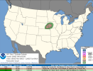
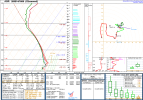
Starting a thread for today's severe weather threat, despite recent downtrends in the forecast, because today is still the highest tornado potential we've seen in a month and I think today's observed soundings reveal a potent (yet highly conditional) tornado environment. The ceiling is certainly high today.
1PM CDT Aberdeen, SD Sounding reveals almost 500 m2/s2 0-1km SRH
1 PM CDT Omaha, NE Sounding
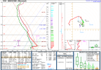
1PM CDT North Platte, NE Sounding reveals surface CAPE builds fast where clouds are clearing...

Starting a thread for today's severe weather threat, despite recent downtrends in the forecast, because today is still the highest tornado potential we've seen in a month and I think today's observed soundings reveal a potent (yet highly conditional) tornado environment. The ceiling is certainly high today.
1PM CDT Aberdeen, SD Sounding reveals almost 500 m2/s2 0-1km SRH
1 PM CDT Omaha, NE Sounding
1PM CDT North Platte, NE Sounding reveals surface CAPE builds fast where clouds are clearing...
- Grand Poo Bah
- Replies: 45
- Forum: General Weather Discussion

akt1985
Member
I heard that things were a mess Saturday night at Jordan Hare Stadium between Auburn and Southern Miss with the lightning delay.
jackhutwx
Member
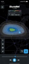
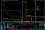
eyeing out 9/18 for a possible severe weather setup. decent amount of instability and temp profiles are also pretty good. stormnet even has a 30+% tornado outline for east-central iowa and the 10-20% stretches into NW and just the general northern IL region (no surprise there). would like to hear your thoughts about this.
Attachments
![soundings-[42.25,-92]-gfs-scp-us_mw-2026091506-87.png](https://attachments.talkweather.com/data/attachments/55/55738-833f9e81ba3d355409342a14522333c7.jpg?hash=L8HiGkVQrO)
Kds86z
Member

CheeselandSkies
Member
eyeing out 9/18 for a possible severe weather setup. decent amount of instability and temp profiles are also pretty good. stormnet even has a 30+% tornado outline for east-central iowa and the 10-20% stretches into NW and just the general northern IL region (no surprise there). would like to hear your thoughts about this.
Friday has most of the same problems that Monday did; namely impressive low-level shear but anemic deep-layer shear leading to very truncated mid and upper-level hodographs. High PWATs as well, storms if they happen are going to be water bombs. At least the low-level thermos might be a little better. Saving grace might be if weak SR inflow leads to mini-supercells, which don't always turn out as HP as the hodograph would suggest due to lower overall mass.
NWS Buffalo is based AF!
(Also, November 2028 cannot come soon enough...)
We've been under a flood watch or warning consistently since Sunday. This atmospheric river we're under is crazy. The hardware store was packed today and employees were restocking 25 foot sump pump extension tubes from the back like TVs on Black Friday. Basically everyone is dealing with water in their basements.
Kds86z
Member
I live quite close to the peak of the dome!
(And yeah, it's gotten quite hot here for the past week or two, with at least a few more days of more heat expected.)
jackhutwx
Member
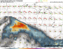
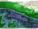
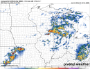
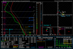
seeing a similar setup (maybe weaker) tomorrow for northern/NW illinois. for the most part, looks like slopvection on the hrrr, but other CAMs have a nice defined line going through most of northern illinois and the chicago region. pwat values are pretty high (~1.8-2.2in, depending on the model) so could def be a (flash) flooding threat at the least, but the environment is there for at least a brief spinup. attached is the hrrr sounding for what it would appear to be the 'peak' of the event. the environment is def there but there's no good convection to take it. again, would like to hear anyone's thoughts, still newish to forecasting lolFriday has most of the same problems that Monday did; namely impressive low-level shear but anemic deep-layer shear leading to very truncated mid and upper-level hodographs. High PWATs as well, storms if they happen are going to be water bombs. At least the low-level thermos might be a little better. Saving grace might be if weak SR inflow leads to mini-supercells, which don't always turn out as HP as the hodograph would suggest due to lower overall mass.
View attachment 54991

joshoctober16
Member
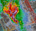
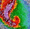
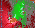
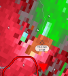
tornado warning from a cell with a extreme high DBZ level
joshoctober16
Member
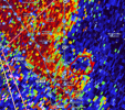
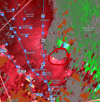
HUGE cc drop
joshoctober16
Member
while it just touched rigth when it exited the city is heading for a other town (peterson)
Kds86z
Member
List locations…

WeathermanLeprechaun
Member
That was a potentially EF3+ intensity tornado in Utah. @N0mz I'm calling you because orographic influence absolutely had something to do with this one.
Just to put this into perspective, this is likely the first time a 80+ kt VROT couplet has been recorded this far West in the US and was also likely a major tornado. Utah hasn't seen a tornado like this intensity wise since potentially 1993. Wow.
Just to put this into perspective, this is likely the first time a 80+ kt VROT couplet has been recorded this far West in the US and was also likely a major tornado. Utah hasn't seen a tornado like this intensity wise since potentially 1993. Wow.
That was a potentially EF3+ intensity tornado in Utah. @N0mz I'm calling you because orographic influence absolutely had something to do with this one.
Just to put this into perspective, this is likely the first time a 80+ kt VROT couplet has been recorded this far West in the US and was also likely a major tornado. Utah hasn't seen a tornado like this intensity wise since potentially 1993. Wow.
Also that is insane tornado footage, tornadoes in the rockies look super weird.
akt1985
Member
Remember that the tornado that hit downtown Salt Lake City, Utah in August 1999 was only an F2 at its peak.
wasatch
Member
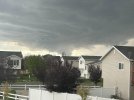
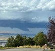
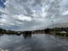
I live just a bit north of this tornado, got a picture of it forming from my house in Syracuse, a picture from my sister to the south of it (near Bountiful), and a picture from my son who was in Farmington as it went thru tornado warned... pretty crazy day.