• Welcome to TalkWeather!
    We see you lurking around TalkWeather! Take the extra step and join us today to view attachments, see less ads and maybe even join the discussion.
    CLICK TO JOIN TALKWEATHER

Severe Weather 2026

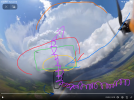
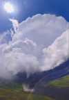
Best view of all of the parts of a supercell to date IMO, captured by OTIS
The dark blue (RFD), dark red (FFI), tornado (black), wall cloud (yellow), mesocyclone (green), dry slot (red), inflow tail (blue), updraft and streamwise vorticity (purple) and the clean cut anvil (orange) are all easily visible.
The rainbow and the tornado being over a lake of course if all of that wasn’t enough.
1784065878073.png
 
Best view of all of the parts of a supercell to date IMO, captured by OTIS
The dark blue (RFD), dark red (FFI), tornado (black), wall cloud (yellow), mesocyclone (green), dry slot (red), inflow tail (blue), updraft and streamwise vorticity (purple) and the clean cut anvil (orange) are all easily visible.
The rainbow and the tornado being over a lake of course if all of that wasn’t enough.
View attachment 54140
streamwise vorticity position is wrong , would be pointing towards the camera , behind the tornado where the tail cloud would be at.
 
streamwise vorticity position is wrong , would be pointing towards the camera , behind the tornado where the tail cloud would be at.
Erm, no, the stream wise vorticity current is usually located just south of the precip shield of the supercell, where the warm conveyor belt is located. The point of ingestion is where this warm conveyor belt (or proto warm front if you want to call it) meets up with the RFD front, which is usually south or southeast of the updraft.

Obviously, they’re exceptions to this and really depends on the location of the baroclinic boundary, which can be located via the tail cloud, which is why I put it where I did.
 
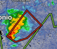
Tornado warning north of San Antonio, to go with the ton of rain that region has received recently. Flooding, washouts, and rescues in the Texas hill country the last couple of days. I haven't followed closely, but saw last night that near Uvalde, TX had gotten 12 inches in 1 day.
 
Erm, no, the stream wise vorticity current is usually located just south of the precip shield of the supercell, where the warm conveyor belt is located. The point of ingestion is where this warm conveyor belt (or proto warm front if you want to call it) meets up with the RFD front, which is usually south or southeast of the updraft.

Obviously, they’re exceptions to this and really depends on the location of the baroclinic boundary, which can be located via the tail cloud, which is why I put it where I did.
1784125522328.png
1784125779985.png
SWVC tends to come from the forward flank boundary , you put it at the RFD boundary
 
Oooh this could get interesting..... I'm just here for the spicy storm bickering

Murder She Wrote Popcorn GIF
 
View attachment 54144
View attachment 54145
SWVC tends to come from the forward flank boundary , you put it at the RFD boundary
View attachment 54144
View attachment 54145
SWVC tends to come from the forward flank boundary , you put it at the RFD boundary
Ah, I see where you might’ve gotten confused.
It’s difficult to tell from the drone perspective, but I indeed put the SVC along the FFB, not the RFD, which is easy to confuse.
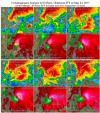
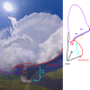
These graphics you posted also shows that the current runs right along where the inflow tail is located, (after it wraps around the west side of the updraft).
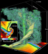
The 3d computer simulation here also shows the SVC seemingly riding along the RFD boundary, (it isn’t) but again also shows it’s hard to tell due to perspective.
1784129913696.png
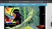
I think this graphic here shows how to draw it up the best visually since it terminates the current right before it hooks back in along the FF inflow tail. (Obviously it doesn’t do this actually but it’s easier to draw up).
1784130371533.png
 
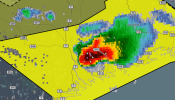
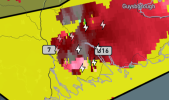
Third tornado warning in 24 hours for San Antonio! This one has a defined hook echo on it too.
Screenshot (208).png
Tornado warning north of San Antonio, to go with the ton of rain that region has received recently. Flooding, washouts, and rescues in the Texas hill country the last couple of days. I haven't followed closely, but saw last night that near Uvalde, TX had gotten 12 inches in 1 day.

For a tropical funnel, that thing had teeth.
5c81f7a8-297f-4c6b-9e66-82fa4a18f318-DRONETORNADODAMAGE_frame_47930.jpeg


I also found a roof shingle in my pool. Didn't experience any high winds and we're not missing any shingles, so it was probably carried here.
 
Monday has looked rather interesting for the Midwest for a while now. 12Z GFS upped the ante with a large area of 0-3KM EHI >7 over IL/E. IA/S. WI. Capping concerns are present, but don't look like a guaranteed event-buster at this point.

SPC...

The next time/area of potential concern will be across portions of
the Upper Midwest/western Great Lakes on Monday/Day-5. Here, both
the physics-based GEFS and EC ensemble guidance and the GFS and
EC-based AI emulators are in good agreement that height falls will
overspread the region ahead of the next short-wave trough. However,
the GFS-based ensemble means are considerably weaker with the
strength of the trough, partially owing to differences in timing of
the main wave. The background environment will likely be favorable
for severe thunderstorms, with MUCAPE values in the 2000-3000 J/kg
range and strong vertical shear, the magnitude of which will be
largely influenced by the strength of the mid-level wave. That said,
west/southwesterly flow in the 925-700 millibar layer should support
a strong EML given the antecedent hot and dry airmass upstream of
this flow. This leads to concerns regarding convective initiation
within the favorable severe background environment. These concerns
are supported by the ensemble guidance with varying degrees of QPF
shown within the ensemble members. Given this is still 5 days away,
will hold off on introducing unconditional severe probabilities with
this forecast.

..Marsh.. 07/16/2026
 
Back
Top