
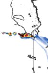
Some images coming out of this tornado that went very close to the Tulliby Lake area. I believe there is a lot of energy infrastructure in the area and some homes and was a cc coefficient so not sure if it might be doing damage to something.
Navigation
Install the app
How to install the app on iOS
Follow along with the video below to see how to install our site as a web app on your home screen.
Note: This feature may not be available in some browsers.
More options
-
Welcome to TalkWeather! We see you lurking around TalkWeather! Take the extra step and join us today to view attachments, see less ads and maybe even join the discussion. CLICK TO JOIN TALKWEATHER
You are using an out of date browser. It may not display this or other websites correctly.
You should upgrade or use an alternative browser.
You should upgrade or use an alternative browser.
Severe Weather 2026
- Thread starter KevinH
- Start date

joshoctober16
Member
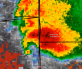
major debris ball , deep blue cc drop on it.
More supercells and tornado warnings going up over Saskatchewan some pretty high STP over Saskatchewan right now of 6 from what I can see on HRRR although this doesn't extend into northern/central Sask from what I can see... but can't rule out a strong tornado from these cells.

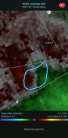
Damage coming in from the earlier Tulliby Lake tornado in Alberta we may have another EF4 candidate this year
Also lots of other tornadoes being reported in Saskatchewan today. This and yesterday may actually end up being the most profilic tornado outbreak in Canadian history? I believe the largest 1 day is 22. But this might be the largest overall? Anyone have statistics on this?
Also lots of other tornadoes being reported in Saskatchewan today. This and yesterday may actually end up being the most profilic tornado outbreak in Canadian history? I believe the largest 1 day is 22. But this might be the largest overall? Anyone have statistics on this?

Kds86z
Member
Interesting:
TUESDAY/DAY 4 -- NEW ENGLAND
MULTIPLE ENSEMBLE SYSTEMS CONTINUE TO SUPPORT A FAVORABLE SEVERE
WEATHER ENVIRONMENT BEING IN PLACE ACROSS NEW ENGLAND ON TUESDAY.
STRONG DIURNAL HEATING AND SOUTHWESTERLY SURFACE FLOW SHOULD ALLOW
SURFACE TEMPERATURES TO WARM INTO THE MID-80FS TO PERHAPS LOW-90FS
BY LATE AFTERNOON AHEAD OF A SEASONABLY STRONG SURFACE COLD FRONT.
AHEAD OF THE COLD FRONT, SURFACE DEWPOINT TEMPERATURES SHOULD RISE
INTO THE 60FS TO PERHAPS 70FS, LEADING TO MUCAPE BETWEEN 1000-2000
J/KG. CURRENT THINKING IS THAT THUNDERSTORMS WILL DEVELOP ALONG AND
AHEAD OF THE SURFACE COLD FRONT DURING THE AFTERNOON ACROSS QUEBEC
AND MOVE INTO NEW ENGLAND DURING THE LATE AFTERNOON BEFORE
DISSIPATING OVERNIGHT. STRONG VERTICAL SHEAR IN EXCESS OF 50 KNOTS
WILL COMBINE WITH STRONG INSTABILITY TO SUPPORT SEVERE
THUNDERSTORMS. THE MOST PROBABLE SCENARIO IS FOR ONE OR MORE BROKEN
LINES OF STORMS TO MOVE ACROSS THE REGION, WITH PERHAPS A FEW
EMBEDDED SUPERCELLS. ALL SEVERE HAZARDS SEEM POSSIBLE AT THIS TIME.
TUESDAY/DAY 4 -- NEW ENGLAND
MULTIPLE ENSEMBLE SYSTEMS CONTINUE TO SUPPORT A FAVORABLE SEVERE
WEATHER ENVIRONMENT BEING IN PLACE ACROSS NEW ENGLAND ON TUESDAY.
STRONG DIURNAL HEATING AND SOUTHWESTERLY SURFACE FLOW SHOULD ALLOW
SURFACE TEMPERATURES TO WARM INTO THE MID-80FS TO PERHAPS LOW-90FS
BY LATE AFTERNOON AHEAD OF A SEASONABLY STRONG SURFACE COLD FRONT.
AHEAD OF THE COLD FRONT, SURFACE DEWPOINT TEMPERATURES SHOULD RISE
INTO THE 60FS TO PERHAPS 70FS, LEADING TO MUCAPE BETWEEN 1000-2000
J/KG. CURRENT THINKING IS THAT THUNDERSTORMS WILL DEVELOP ALONG AND
AHEAD OF THE SURFACE COLD FRONT DURING THE AFTERNOON ACROSS QUEBEC
AND MOVE INTO NEW ENGLAND DURING THE LATE AFTERNOON BEFORE
DISSIPATING OVERNIGHT. STRONG VERTICAL SHEAR IN EXCESS OF 50 KNOTS
WILL COMBINE WITH STRONG INSTABILITY TO SUPPORT SEVERE
THUNDERSTORMS. THE MOST PROBABLE SCENARIO IS FOR ONE OR MORE BROKEN
LINES OF STORMS TO MOVE ACROSS THE REGION, WITH PERHAPS A FEW
EMBEDDED SUPERCELLS. ALL SEVERE HAZARDS SEEM POSSIBLE AT THIS TIME.
Kds86z
Member

CheeselandSkies
Member
SPC's outlook the last couple days has been focused on the mid-Atlantic for Friday 7/17, but the GFS has consistently had a region of enhanced EHI over the upper Midwest for that timeframe.
Forecast sounding from the latest run, along the warm front in southern WI. Of course at this range and especially with it being summer, this can and will change.
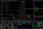
Forecast sounding from the latest run, along the warm front in southern WI. Of course at this range and especially with it being summer, this can and will change.
joshoctober16
Member
think its the first time ive seen sig outline for maine , quebec and new brunswick.
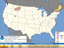
hrrr still isnt reaching that point however the day before has insane STP in ontario
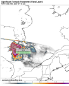
hrrr still isnt reaching that point however the day before has insane STP in ontario

WeathermanLeprechaun
Member
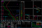
Also, key note that the HRRR legitimately convects in that region of 10+ STP. And the soundings are genuinely the most high end I think I've ever seen for Canada. However, i am typically a finicky day with SE moving days because storms can overconvect and just become a propagating mess. A violent tornado is conditionally possible, and even if mode goes messy, still a evident significant tornado threat. I am heavily intrigued into how this plays out.
Attachments
WeathermanLeprechaun
Member
Damage coming in from the earlier Tulliby Lake tornado in Alberta we may have another EF4 candidate this year
Also lots of other tornadoes being reported in Saskatchewan today. This and yesterday may actually end up being the most profilic tornado outbreak in Canadian history? I believe the largest 1 day is 22. But this might be the largest overall? Anyone have statistics on this?
On long range models, this period was surprisingly potent and evident so I'm not surprised that we've seen multiple significant tornadoes in Alberta and Sask. I did mention last night on my writeup a while back but I was a bit laid back with the wording. Still has been a insane period
Well the thing with this area is that this is extremely unpopulated as this is the middle of the Canadian shield where almost no one lives. Any validation of tornadoes here will most likely have to be done by satellite unless the tornado happens to be very close to the Trans-Canada highway. So probably as good a place as any for violent tornadoes to occur because it is extremely unlikely they will hit anything. The outbreak on Tuesday from Quebec-New Brunswick is probably more concerning as if those storms go off earlier the chance of damaging tornadoes in populated areas of Quebec are high as well as the Saint John River valley and Maine/NB is definitely an area where the public doesn't have a lot of experience with tornadoes nor is there any kind of tornado warning system.Also, key note that the HRRR legitimately convects in that region of 10+ STP. And the soundings are genuinely the most high end I think I've ever seen for Canada. However, i am typically a finicky day with SE moving days because storms can overconvect and just become a propagating mess. A violent tornado is conditionally possible, and even if mode goes messy, still a evident significant tornado threat. I am heavily intrigued into how this plays out.
WeathermanLeprechaun
Member
That's fair.Well the thing with this area is that this is extremely unpopulated as this is the middle of the Canadian shield where almost no one lives. Any validation of tornadoes here will most likely have to be done by satellite unless the tornado happens to be very close to the Trans-Canada highway. So probably as good a place as any for violent tornadoes to occur because it is extremely unlikely they will hit anything. The outbreak on Tuesday from Quebec-New Brunswick is probably more concerning as if those storms go off earlier the chance of damaging tornadoes in populated areas of Quebec are high as well as the Saint John River valley and Maine/NB is definitely an area where the public doesn't have a lot of experience with tornadoes nor is there any kind of tornado warning system.
I'm not sold on a "outbreak" yet on Tuesday in that area but it is a interesting setup. I think a isolated tornado threat, wind and hail. The advection of a EML is the most key thing to Tuesday. I do expect leftovers from Monday to perhaps act as morning convection.
You're right, I didn't mean to imply a guaranteed outbreak and should've used the term risk instead.That's fair.
I'm not sold on a "outbreak" yet on Tuesday in that area but it is a interesting setup. I think a isolated tornado threat, wind and hail. The advection of a EML is the most key thing to Tuesday. I do expect leftovers from Monday to perhaps act as morning convection.
Someone got drone footage of the path of Tulliby Lake, Alberta tornado very, very severe forest damage, also looks like there may be a spot where some of the top soil was removed early in the footage. Also looks like it threw some tanks or something before taking a house completely off it's foundation. Definitely an EF4 candidate from what I'm seeing:
Also some heavy oil tanks appear to have been taken out of the ground. Very curious to see what the NTP thinks of this damage.
Also some heavy oil tanks appear to have been taken out of the ground. Very curious to see what the NTP thinks of this damage.
Last edited:
WeathermanLeprechaun
Member
Someone got drone footage of the path of Tulliby Lake, Alberta tornado very, very severe forest damage, also looks like there may be a spot where some of the top soil was removed early in the footage. Also looks like it threw some tanks or something before taking a house completely off it's foundation. Definitely an EF4 candidate from what I'm seeing:
Also some heavy oil tanks appear to have been taken out of the ground. Very curious to see what the NTP thinks of this damage.
This tornado reminds me of Ashby in its rather innocent appearance but the damage was pretty nasty. I think the Canadian season is being underlooked because boy, is it going off.
Kds86z
Member
Day 2 is not something you see every day for New England ..
GIVEN THE DEGREE OF INSTABILITY AND STRENGTH OF THE FLOW, SEVERE
THUNDERSTORM WINDS ARE LIKELY (SOME SIGNIFICANT). LARGE HAIL WILL
ALSO BE POSSIBLE WITH ANY STORMS. ADDITIONALLY, FORECAST SOUNDINGS
SHOW ENOUGH LOW-LEVEL
CURVATURE TO SUPPORT A TORNADO THREAT,
INCLUDING A STRONG TORNADO OR TWO, WITH ANY SUSTAINED SURFACE-BASED
SUPERCELL.
GIVEN THE DEGREE OF INSTABILITY AND STRENGTH OF THE FLOW, SEVERE
THUNDERSTORM WINDS ARE LIKELY (SOME SIGNIFICANT). LARGE HAIL WILL
ALSO BE POSSIBLE WITH ANY STORMS. ADDITIONALLY, FORECAST SOUNDINGS
SHOW ENOUGH LOW-LEVEL
CURVATURE TO SUPPORT A TORNADO THREAT,
INCLUDING A STRONG TORNADO OR TWO, WITH ANY SUSTAINED SURFACE-BASED
SUPERCELL.
Attachments
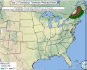
Regarding the New England threat I saw a model run last night of the NAM which had the outbreak showing as a bunch of discrete or semi-discrete supercells in Quebec and New Brunswick with the hodographs having PDS tornado as most likely risk in Quebec and tornadoes as most likely risk in NB. I think there is still a chance for some nasty tornadoes up in Eastern Canada tomorrow. I am very puzzled by Environment Canada's seeming underplaying of the threat on the significant weather outlook... compared to the SPC?
akt1985
Member
There is an Enhanced Risk out for northern New England for Tuesday.
joshoctober16
Member
looks like its not just a maine , new brunswick , quebec event but now all the way to new york
quebec sounding
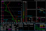
New brunswick sounding
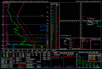
Maine Sounding
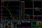 New york Sounding
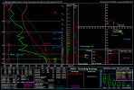
quebec sounding
New brunswick sounding
Maine Sounding
New york Sounding