• Welcome to TalkWeather!
    We see you lurking around TalkWeather! Take the extra step and join us today to view attachments, see less ads and maybe even join the discussion.
    CLICK TO JOIN TALKWEATHER

Severe Weather 2026

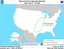
Really think the 2nd April is one to watch, with models quickly converging onto a solution which I reckon could be the first robust severe threat in a while across IA/MO/IL

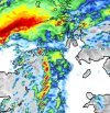
Models have shifted towards the subtle shortwave which travels fairly quickly through the Midwest on Thursday having stronger flow and being more developed. This leads to a stronger low level response with a pretty strong ~50/60kt LLJ being modelled during the entire duration of the event period. To be honest, the modelled windspeeds actually surprised me given the weaker mid-upper level flow.

trend-ecmwf_full-2026033018-f075.500wh.conus.gif1774914265067.png

The result is pretty decent moisture return. ECM here with a fairly widespread 60F dp, and a pacific front kind of feature. Due to the shape of the upper trough you start to get some colder 500mb temperatures overlapping this warm sector, and the result is 1000j/kg being modelled on this ECM run. Safe to assume this would increase as we get closer to the event.

1774914412872.png1774914539457.png

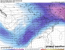
Early days still considering its still D3/4 range... but these classic setups will always catch my eye. The general warm sector & trough geometry, plus the forcing mechanisms look quite 'clean' here in a way that could really favour (semi)-discrete supercells as the primary storm mode. Some of the forecast soundings have an environment easily favourable of strong tornadoes.

1774914750145.png

In literally the last few hours or so having looked through the models, this setup is really catching my eye, and I think it might be good to open a thread for this one soon. Especially the ECM/UKM scenarios would likely be severe weather outbreaks.
 
Yeah, this is annoying because that's the day I fly out to Oklahoma and this wasn't on the models even a day and a half ago. Watch this produce in my backyard hours after I leave and Friday/Saturday turn out to be positive tilt slop which they are once again trending toward on the Euro. Ugggggh.

BTW I'm starting a thread because this is a fairly apparent at least 3-day stretch of at least some severe weather, somewhere by now.

 
Just a matter of time before SPC outlooks an area for this weekend. Going from near 85 Saturday to upper 50s/low 60s Sunday.
 
Just a couple of hours ago, at sunset on 3/31 in the towns of San Rafael and Toledano in Mendoza, Argentina, were hit by Gorilla Hail measuring several inches. The tropical air mass affecting the region, with dew points around 75°F, combined with the high elevation of the Andes in Mendoza (equivalent to the elevation of the Colorado Rockies in North America), makes this area one of the most conducive in the world for Gorilla and Gargantua Hail.

1000013124.png
1000013123.gif
1000013130.png
 
Last edited:
Next timeframe to watch for severe weather

hazards_d8_14_contours.png

precip_probhazards_d8_14_contours (2).png
 

Attachments

  • hazards_d8_14_contours.png
    hazards_d8_14_contours.png
    940.3 KB · Views: 0
Confirmed and rated ef1
In addition, the area saw significant flooding.

For example, I've attached pictures of some flooding on the campus of Houghton University. This is notable and rather impressive in that said campus is on a bluff above the Genesee River. The village of Houghton, situated closer to the river, suffered more significant flooding. I attended Houghton and, fun fact, used to live in one of the flooded houses. The stream at left is called Houghton Creek.
 

Attachments

  • IMG_20260402_121202.png
    IMG_20260402_121202.png
    3.1 MB · Views: 0
  • 657518431_1392834652886697_5211458665590320049_n-750x440.jpg
    657518431_1392834652886697_5211458665590320049_n-750x440.jpg
    71.9 KB · Views: 0
dixie out here dodging tornado threats like neo in the matrix. still no sign of anything SE of arklatex through mid april.
Yeah really unreal how this severe season has turned out for us this far . Think it’s done here be honest before it started . That ridge not letting go
 
Yeah really unreal how this severe season has turned out for us this far . Think it’s done here be honest before it started . That ridge not letting go
Two things can be true:

1) It’s been great in portions of Dixie where there has not been much severe weather activity so far this spring.

2) We still have some ways to go before the season can truly be declared over.

Let’s not get ahead of ourselves. Just like in sports, a team can be up 28-3 and still lose, such as in football - bonus points if you know what game I am referring to ;)

Hopefully it continues to be quiet (everyone would love that), but let’s not call it a wrap already. It would be nice to have some rain before summer arrives and ease some drought concerns. Maybe that comes without severe weather or maybe it does, but taking the patterns and systems one at a time is the best approach.

That 2nd half was the worst offensive and situational coaching I've ever seen. And I know football way, way more than I know weather.
 
Two things can be true:

1) It’s been great in portions of Dixie where there has not been much severe weather activity so far this spring.

2) We still have some ways to go before the season can truly be declared over.

Let’s not get ahead of ourselves. Just like in sports, a team can be up 28-3 and still lose, such as in football - bonus points if you know what game I am referring to ;)

Hopefully it continues to be quiet (everyone would love that), but let’s not call it a wrap already. It would be nice to have some rain before summer arrives and ease some drought concerns. Maybe that comes without severe weather or maybe it does, but taking the patterns and systems one at a time is the best approach.
unless a full scale pattern change happens, dixie is done for the spring. troughing continues to favor the upper midwest for ejecting lows.

still don’t see that in the modeling
 
Screenshot 2026-04-03 at 4.45.54 PM.pngScreenshot 2026-04-03 at 4.46.12 PM.png
Solid signal for deep troughing, albeit with somewhat lackluster flow at this time, across the west in the 4/9-4/14 timeframe. Based on some of the operationals, 4/11-12 may be a day to watch.
 

Attachments

  • Screenshot 2026-04-03 at 4.45.45 PM.png
    Screenshot 2026-04-03 at 4.45.45 PM.png
    1.6 MB · Views: 0
Back
Top