
Navigation
Install the app
How to install the app on iOS
Follow along with the video below to see how to install our site as a web app on your home screen.
Note: This feature may not be available in some browsers.
More options
-
Welcome to TalkWeather! We see you lurking around TalkWeather! Take the extra step and join us today to view attachments, see less ads and maybe even join the discussion. CLICK TO JOIN TALKWEATHER
You are using an out of date browser. It may not display this or other websites correctly.
You should upgrade or use an alternative browser.
You should upgrade or use an alternative browser.
Severe Weather 2026
- Thread starter KevinH
- Start date
The record high temp for central Iowa on March 21st is 82 degrees set in 1878. We're forecast to get up to 86. Gonna be a fun El Nino.
Already 86 here today and supposed to break 90 easily tomorrow. It's too damn early for this.The record high temp for central Iowa on March 21st is 82 degrees set in 1878. We're forecast to get up to 86. Gonna be a fun El Nino.
KakashiHatake2000
Member
Yes I know right totally agree thesuckzone
Yeah. A severe weather threat return the first week of April seems like a good idea. In fact, you could tell in yesterday's 12z Euro that there was definitely potential around or just after April 3rd. Today's 12z Euro features a trough ejection by April 3rd.
Attachments
N
Not here anymore
Guest
Enjoy this beautiful Spring weather while you can. An April atmospheric assualt may occur the 1st week in April.Its only the EC deterministic model but waiting on to see how the ensembles show up


Last edited by a moderator:
Cyclonic Paracosm
Member
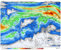
I've been hearing a wee bit abt first week of april and I can see whyEnjoy this beautiful Spring weather while you can. An April atmospheric assualt may occur the 1st week in April.Its only the EC deterministic model but waiting on to see how the ensembles show up
View attachment 52140
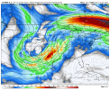
View attachment 52141View attachment 52142
CheeselandSkies
Member
Verbatim I need that to slow down by a day or two. First chase day of the tour is the 3rd, if the warm sector is already east of the MS Valley by then we won't be able to catch it. Would suck to miss a big trough by a day and then have it sweep out the Gulf for a week. However it's just a nearly 400-hour op run so I'm not sweating it too much...yet.
N
Not here anymore
Guest
Matthew Cappucci
@MatthewCappucci
Early April, particularly between April 1-8, looks active from a severe weather/tornado standpoint. We'll also likely see above-average rainfall across portions of the Ozarks, Mid-south and Mississippi Valley.A large-scale pattern reversal will favor troughing, or a jet stream dip in the west. Chilly air will spill south over the Rockies in that jet stream dip. Warmth and moisture will build in the east. Periodically, lobes of that cold pocket will pinch off, bowling eastwards and kicking up that warmer, wetter air mass over the Central U.S. With the jet stream roaring overhead, adding wind energy, some of the storms will be strong to severe. I expect an uptick in tornado activity as well.It's also the time of year when tornado activity tends to ramp up anyway. Now is a good time to clean the cobwebs out of the storm cellars, brush up on your severe weather plan and coordinate with friends, family and loved ones.
CheeselandSkies
Member
Yeah, I saw that on his Facebook.
Prior couple CFS runs have been kind of meh for my chase tour. Now the 18Z that just populated on CoD...inject that directly into my veins.
Prior couple CFS runs have been kind of meh for my chase tour. Now the 18Z that just populated on CoD...inject that directly into my veins.
slenker
Member
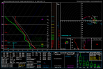
12z NAM had a pretty good uptrend in a narrow corridor from central OH to eastern PA, from the looks of it. I'd like to hear some inputs on the analogs being shown, if any. Here's a sounding from eastern OH at 18z for the 12z NAM run today:

WeathermanLeprechaun
Member
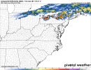
12z HRRR suggests potential for a severe thunderstorm warning spam day in PA, with several discrete supercells capable of damaging wind/large hail. Do not see tornado potential with these. May need a large eastward expansion of the slight risk to account for this convection. After 00z, likely a elevated bow echo with slightly severe potential. SE OH does fire but a limited window for damaging wind/large hail due to crapvection leading behind. Interesting day ahead for svr potential on Sunday
Attachments
WeathermanLeprechaun
Member
Think NAM is overhyping Sunday. Whilst I can see widespread svr convection with eastward extent, i do not see much tornadic potential with the limited LLJ12z NAM had a pretty good uptrend in a narrow corridor from central OH to eastern PA, from the looks of it. I'd like to hear some inputs on the analogs being shown, if any. Here's a sounding from eastern OH at 18z for the 12z NAM run today:
View attachment 52147
WeathermanLeprechaun
Member
There's a lot of hype for Sunday due to the 12z HRRR but a lot forget UH tracks mean large hail too. Sunday is one of those days.
Ozonelayer
Member
I'd honestly love to get some pictures of these hailers. Might try if one passes by my houseThere's a lot of hype for Sunday due to the 12z HRRR but a lot forget UH tracks mean large hail too. Sunday is one of those days.
Kds86z
Member
Latest day 1, as probs are currently 2% for tornadoes
LL TORNADO THREAT, CONDITIONAL UPON SUFFICIENT LOW-LEVEL
MOISTENING. A CORRIDOR OF GREATER TORNADO PROBABILITIES MAY
EVENTUALLY BE NEEDED, IF TRENDS SUPPORT MORE SUBSTANTIAL MOISTURE
RETURN THAN CURRENTLY EXPECTED.
LL TORNADO THREAT, CONDITIONAL UPON SUFFICIENT LOW-LEVEL
MOISTENING. A CORRIDOR OF GREATER TORNADO PROBABILITIES MAY
EVENTUALLY BE NEEDED, IF TRENDS SUPPORT MORE SUBSTANTIAL MOISTURE
RETURN THAN CURRENTLY EXPECTED.
Kds86z
Member
83 tomorrow then 50 Monday, this wild drop will be 3rd weekend in row I believe.. smh
KakashiHatake2000
Member
Also there’s a marginal risk out for today for East Tennessee and their expecting hail there too don’t know what other hazards
Cyclonic Paracosm
Member

Sorry for no link it was a grab from a server with only the pic but April could be something
CheeselandSkies
Member
View attachment 52161
Sorry for no link it was a grab from a server with only the pic but April could be something
Hope it's not a lot of promising setups that cap bu$t!