• Welcome to TalkWeather!
    We see you lurking around TalkWeather! Take the extra step and join us today to view attachments, see less ads and maybe even join the discussion.
    CLICK TO JOIN TALKWEATHER

Severe Weather 2024

Glad someone is. We had snowflakes here today. Before Thanksgiving. I want to speak to the manager.
May I Please Customer Service GIF by Kim's Convenience
 
SPC may consider adding risk areas for D5/6 in the coming days. Fairly standard late fall setup; winds will be somewhat veered but the system itself will be fairly robust.
Day 4-8 Convective Outlook
NWS Storm Prediction Center Norman OK
0320 AM CST Sat Nov 23 2024

Valid 261200Z - 011200Z

...DISCUSSION...
On Tue/D4, an upper trough will pivot northeastward from the Great
Lakes into southern Quebec, with temporary zonal flow across much of
the CONUS. Moisture along the central Gulf Coast will be quickly
shunted offshore as a cold front pushes south.

Models are in good agreement depicting another shortwave trough over
the central Rockies on Wed/D5, with some amplification possible into
the southern Plains Wed night. This trough will maintain a positive
tilt on Thu/D6 with a 65-75 kt 500 mb speed max extending from TX to
the TN/OH Valleys by 00Z Fri/D7.

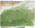
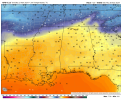
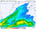
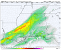
During the day on Wed/D5, low pressure is forecast to develop over
OK, and will translate east/northeast into KY/TN Wed night ahead of
a cold front. South of this front, a relatively large area of mid to
upper 60s F dewpoints will develop, especially Wed night, from
eastern TX across LA and MS. Given the positive tilt of the upper
trough, winds around 850 mb will be out of the west/southwest,
reducing low-level shear somewhat. In addition, speeds are not
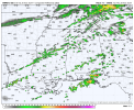
expected to be particularly strong. Still, thunderstorms will likely
develop late Wed/D5 over the lower MS and TN Valleys near the cold
front. Greater thunderstorm coverage is expected on Thu/D6 over much
of the Southeast and ahead of a strengthening cold front. Even with
veered low-level winds, the strong deep-layer shear and focus along
the front may provide a risk of severe/wind storms. This area will
be monitored for upgrades in later outlooks as predictability
increases.

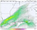
From Fri/D7 into Sat/D8, a secondary speed max moving out of the
upper MS Valley/Great Lakes will likely phase with the southern
trough, eventually enveloping the eastern CONUS, and reinforcing
stable air behind the cold front.

..Jewell.. 11/23/2024
 
Gonna depend on how far north the warm front lifts as far as severity/extent of overall threat. For example, both the 6z GFS and 00z Canadian have low dewpoints in the low 60s with max temps just around 64. This would put area from Southern/Central MS into Central AL in a threat with the Gulf Coast having the greatest threat. The GFS would have a threat for parts of North MS and North AL while the Canadian would be more from southern North MS counties into Central AL. On the other hand, 00z Euro shows warm front getting further north with high temps nearing 70 and dewpoints around 65. Both NWS Jackson and Memphis mention this warm front lifting north. The Euro would be a more regional wide threat. 12z GFS is a bit more robust with temperatures/dewpoints (though highest dewpoints of 65 confined to MS Delta region) while 12z Canadian is not as robust with either one.
 

Attachments

  • gfs-deterministic-alms-dew2m_f-2784400.png 6z.png
    gfs-deterministic-alms-dew2m_f-2784400.png 6z.png
    130.9 KB · Views: 0
  • gem-all-alms-t2m_f-2816800.png
    gem-all-alms-t2m_f-2816800.png
    140.2 KB · Views: 0
  • gem-all-alms-dew2m_f-2816800.png
    gem-all-alms-dew2m_f-2816800.png
    133.4 KB · Views: 0
  • ecmwf-deterministic-alms-t2m_f-2784400.png
    ecmwf-deterministic-alms-t2m_f-2784400.png
    140.6 KB · Views: 0
  • ecmwf-deterministic-alms-dew2m_f-2795200.png
    ecmwf-deterministic-alms-dew2m_f-2795200.png
    133.7 KB · Views: 0
  • gfs-deterministic-alms-t2m_f-2784400.png
    gfs-deterministic-alms-t2m_f-2784400.png
    137.6 KB · Views: 0
GEFS has become increasingly consistent regarding the potential for severe storms on Thanksgiving Day. Run-to-run, the GFS is also showing increasingly favorable trough ejection. Euro is arguably more impressive. Certainly bears watching.
trend-gefsens-2024112318-f120.scp-prob01.conus.giftrend-gfs-2024112318-f120.500wh.conus.gif
 
I would like to see higher dewpoints around 65 on the GFS, but yeah, the GFS seems to be trending towards Euro with regards to higher temperatures (upper 60s/low 70s) and more low to near mid 60s dewpoints over a wider area. You can definitely see the increase in low to near mid 60 dewpoints from 00z run up to the latest 18z run. I would expect to see a 15% area from SPC by tomorrow. Also, keep a close watch on Monday as a Marginal Risk might be warranted as SPC seems to be hinting at that possibility in the updated Day 3 Discussion.
 
From today's JAN discussion:
What will have more significance is the next shortwave crossing the Rockies on Wednesday. This wave should spin up a low-pressure system in the Southern High Plains on Wednesday, with more moisture recovery and warming occurring over our area in advance of its arrival. A warm, moist advection corridor along the Mississippi River Valley will increase instability Wednesday into Thursday. While the wave will be positively tilted and low-level flow will become more south-southwesterly ahead of the approaching system's cold front, a strengthening upper-level jet streak associated with the system will intersect the developing warm sector along the Gulf Coast. Modest wind shear and decent instability will likely support some chance for severe thunderstorms as the system moves through our area late Wednesday into Thursday. This does include the Thanksgiving Holiday, so area residents and visitors should pay attention to changes in the forecast and updates to timing for best thunderstorm chances. Latest suite of deterministic guidance was a bit faster with the system, and POPs were trended lower for the afternoon and overnight hours Thanksgiving day and night to follow this trend.
 
Really don't want severe weather during the busiest travel week of the year, but keeping up with it will be a good distraction. We said "see you in a little while" to our sweet Cisco yesterday. Hardest thing I've ever had to do in my life.
I'm so sorry, Michelle! My thoughts are with y'all.
 
GFS trended flatter again. SPC less impressed, though would continue to advise folks to keep an eye on things. Will definitely be rainy and potentially stormy, regardless.
trend-gfs-2024112412-f102.500wh.conus.gif
Day 4-8 Convective Outlook
NWS Storm Prediction Center Norman OK
0332 AM CST Sun Nov 24 2024

Valid 271200Z - 021200Z

...DISCUSSION...
Run-to-run model trends indicate generally faster solutions to the
evolving upper trough forecast to move across the central and
eastern CONUS.

On Wed/D4, a positive-tilt upper trough will extend from the upper
MS Valley into the Plains, with 500 mb speed max over 70 kt. This
feature is now forecast to be over the OH/TN Valley by 12Z Thu/D5,
with attendant cold front roughly from WV to southern MS/LA at that
time.

Given this trough speed and geometry, winds around 850 mb will be
west-southwest to west at 40-50 kt. Elevated thunderstorms seem
likely given the antecedent dry air mass in place ahead of the
returning low-level moisture, most notably from KY/TN southward into
northern MS/AL/GA through 12Z Thu/D5. Surface-based storms may
develop across southern areas late along the front, with non-zero
damaging-gust potential given substantial deep-layer shear and wind
magnitude.

ECMWF-based solutions indicate much less storm coverage going into
Thu/D5 as the front accelerates across the Southeast, though some
lingering storms may be ongoing along the front early. Given these
trends, no severe areas will be issued.

..Jewell.. 11/24/2024
 
Right. I've seen a few events where the models just loose the threat entirely then bring it back at last minute.
 
Definitely makes it harder to find the right wording to use to message the threat with when there's not a clear signal.
 
With strong deep-layer flow/shear and generally favorable midlevel
lapse rates expected along/ahead of the front, isolated
strong/damaging gusts and hail will be possible if deep convection
can be sustained Wednesday night. The tornado threat is more
uncertain, due to lingering MLCINH and the eventual undercutting
nature of the front, but a tornado cannot be ruled out if convection
can become near-surface-based with time.
 
Modelling suggests a pretty standard-fare low-end severe threat across the South, especially the southern halves of MS/AL/GA. Sounding attached from central MS at 18Z Thursday. Nothing exceptional but could definitely support a threat for QLCS tornadoes. NAM 3km suggests the possibility of a corridor of convection along the southern parts of AL/GA developing, which would likely limit severe potential north of aforementioned activity. If that were to not materialize, could see more risk for the northern halves of the Southern states.
1732638545011.png1732638626333.png
 
18z HRRR valid at 4am Thursday morning is interesting. Dewpoint around 63 with SBCAPE just above 900. Supercell Composite and STP doesn't jump out at you, but still it's not zero. While it doesn't show a strong squall line, it does show isolated to widely scattered convection (which is concerning from a supercell standpoint). Not much convection on the coast either which you would look for as a limiting factor. Overall wind shear looks decent at 0-6km around 50 to near 60 kt range while 0-3km is around 25 to near 30kts. Depending on how the trend ends up going, I could see a narrow Slight Risk with 5% tornado driven probabilities centered from a corridor near Jackson, MS up into Northwest AL. Otherwise, the only limiting factor I see with this is cloud cover issues.
 

Attachments

  • hrrr-alms-refc-2788000.png 4am.png
    hrrr-alms-refc-2788000.png 4am.png
    191 KB · Views: 0
  • hrrr-alms-dew2m_f-2788000.png 4am.png
    hrrr-alms-dew2m_f-2788000.png 4am.png
    150.4 KB · Views: 0
  • hrrr-alms-cape-2788000.png 4am.png
    hrrr-alms-cape-2788000.png 4am.png
    197.9 KB · Views: 0
  • hrrr-alms-supercell_comp-2788000.png 4am.png
    hrrr-alms-supercell_comp-2788000.png 4am.png
    142.9 KB · Views: 0
  • hrrr-alms-sig_tor-2788000.png 4am.png
    hrrr-alms-sig_tor-2788000.png 4am.png
    150.6 KB · Views: 0
18z HRRR valid at 4am Thursday morning is interesting. Dewpoint around 63 with SBCAPE just above 900. Supercell Composite and STP doesn't jump out at you, but still it's not zero. While it doesn't show a strong squall line, it does show isolated to widely scattered convection (which is concerning from a supercell standpoint). Not much convection on the coast either which you would look for as a limiting factor. Overall wind shear looks decent at 0-6km around 50 to near 60 kt range while 0-3km is around 25 to near 30kts. Depending on how the trend ends up going, I could see a narrow Slight Risk with 5% tornado driven probabilities centered from a corridor near Jackson, MS up into Northwest AL. Otherwise, the only limiting factor I see with this is cloud cover issues.
Often times we don't need much over the minimum threshold for SCP to get storms, though it's just as likely we get a bunch of rain instead.
 
Often times we don't need much over the minimum threshold for SCP to get storms, though it's just as likely we get a bunch of rain instead.
Right and the same goes for CAPE too
 
Well, thank goodness it ends up being just a marginal risk for my area...still gonna keep an eye on things. I hope i'm able to sleep tomorrow night with little issue
 
Back
Top