
I agree and disagree. I don't think there's any problem with providing constructive criticism to the SPC, although that seems to be a rarity these days, but just blindly insulting them is stupid and achieves nothing. And I really don't like the idea of "you can't criticize them because you're not as smart as them". Sure, your opinion or criticism may hold less value or weight because you're not as knowledgeable as, well, literal geniuses. That still doesn't completely invalidate any legitimate criticisms or opinions you may have, in my opinion.I strongly dislike SPC bashing for forecasts.
Navigation
Install the app
How to install the app on iOS
Follow along with the video below to see how to install our site as a web app on your home screen.
Note: This feature may not be available in some browsers.
More options
-
Welcome to TalkWeather! We see you lurking around TalkWeather! Take the extra step and join us today to view attachments, see less ads and maybe even join the discussion. CLICK TO JOIN TALKWEATHER
You are using an out of date browser. It may not display this or other websites correctly.
You should upgrade or use an alternative browser.
You should upgrade or use an alternative browser.
Severe Weather 2024
- Thread starter KevinH
- Start date
cg9450
Member
Well there's an enhanced risk today, if that matters to y'all now.
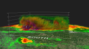
Landspout over northern China yesterday, in summer Northern Plains-esque fashion.
That's awesome looking
Tanner
Member
Why would you attempt to kill us with a good time?Well there's an enhanced risk today, if that matters to y'all now.
Kds86z
Member
I see they added 5% tornado probs. Oh boyWell there's an enhanced risk today, if that matters to y'all now.
slenker
Member
Absolutely. I didn’t mean for it to come off as that. It was more of the fact that the people at the SPC are some of the best meteorologists in the world, and the fact that they are struggling to forecast the events this year accurately isn’t a problem with them, it just means that the forecasts this year were extremely challenging to get correct. There’s still so many things we don’t know about our weather that causes certain setups to flop or certain setups to boom in different ways, and we just need to learn more about it.I agree and disagree. I don't think there's any problem with providing constructive criticism to the SPC, although that seems to be a rarity these days, but just blindly insulting them is stupid and achieves nothing. And I really don't like the idea of "you can't criticize them because you're not as smart as them". Sure, your opinion or criticism may hold less value or weight because you're not as knowledgeable as, well, literal geniuses. That still doesn't completely invalidate any legitimate criticisms or opinions you may have, in my opinion.
atrainguy
Member
Well there's an enhanced risk today, if that matters to y'all now.

Attachments
Kds86z
Member
I know.. I posted above lol
Attachments
TH2002
Member
- Messages
- 4,974
- Reaction score
- 11,116
- Location
- California, United States
- Special Affiliations
- SKYWARN® Volunteer
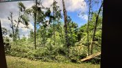
Today, a tornado hit Berdiuzh'e, Russia for the second time since 2011. Much like the 2011 event, it likely originated as a waterspout, had that fascinating "hollow tube" appearance, and made landfall at F1 intensity. So, it was bascially a rehash.
warneagle
Member

warneagle
Member
Today, a tornado hit Berdiuzh'e, Russia for the second time since 2011. Much like the 2011 event, it likely originated as a waterspout, had that fascinating "hollow tube" appearance, and made landfall at F1 intensity. So, it was bascially a rehash.
I’m currently learning Russian and I find it darkly amusing that the word for tornado (smerch) is almost identical phonetically to the word for death (smert’).
atrainguy
Member
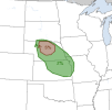
Is it noteworthy when the SPC puts out a Slight Risk 5 days out? Seems uncommon to me that they have enough confidence that they start outlining threats beyond Day 3. I only recently started keeping track of the SPC risk maps though.
"A more appreciable severe threat could develop in parts
of the eastern Dakotas and upper Mississippi Valley on Wednesday, as
a mid-level jet translates eastward through the region. A 15 percent
contour has been added from western Minnesota and eastern North
Dakota southward into north-central Nebraska, where model consensus
suggests the environment will be most favorable for severe storms
during the late afternoon and early evening on Wednesday."
Attachments
Broyles may have just been bored last nightIs it noteworthy when the SPC puts out a Slight Risk 5 days out? Seems uncommon to me that they have enough confidence that they start outlining threats beyond Day 3. I only recently started keeping track of the SPC risk maps though.
"A more appreciable severe threat could develop in parts
of the eastern Dakotas and upper Mississippi Valley on Wednesday, as
a mid-level jet translates eastward through the region. A 15 percent
contour has been added from western Minnesota and eastern North
Dakota southward into north-central Nebraska, where model consensus
suggests the environment will be most favorable for severe storms
during the late afternoon and early evening on Wednesday."
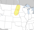
Day 2 marginal is aesthetically pleasing. 
LDay 2 marginal is aesthetically pleasing. View attachment 28561