Remember....
Makes sense then for a significant winter weather and/or severe weather event.
Follow along with the video below to see how to install our site as a web app on your home screen.
Note: This feature may not be available in some browsers.
Remember....
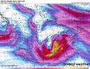
That's impressive.CIPS for the 240 hour time range (1/08-1/11) showing a fairly strong signal for possibility of severe.
View attachment 22731

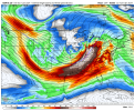
FWIW, yesterday's 12Z Euro run also showing a similar solution (and for the last few runs), though it is at the very end of the run.Tonights 0z GFS still targeting the 9th.

That's a incredibly powerful 500mb streak. My goodness.Tonights 0z GFS still targeting the 9th. View attachment 22741
Yeah, SPC is definitely keeping an eye on this one.From the SPC day 4-8...
Medium-range guidance shows good agreement that another upper trough
will amplify and strengthen around Day 7/Sunday into Day 8/Monday
across the western states and Southwest. As this system ejects over
the southern Plains early next week, inland/northward advance of
low-level moisture should occur across parts of TX and the lower MS
Valley as a surface low quickly deepens across these regions. There
are still some timing differences in the progression of this
pronounced upper trough/low and related surface features. Still,
both forecast instability and deep-layer shear suggest a severe
threat may materialize over parts of central/eastern TX into the
lower MS Valley Monday into Monday night. This area of interest will
be closely monitored for increasing severe potential and
possible/eventual introduction of a 15% severe area pending greater
predictability
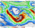
That tilt on the GFS and Euro tho *eyes emoji*6z GFS, 00z Canadian, and 00z Euro
Yeah. It's uncanny to see both the GFS and Euro showing the same type of thing this far in advance too.That tilt on the GFS and Euro tho *eyes emoji*
I'm glad it's January and not April.Yeah. It's uncanny to see both the GFS and Euro showing the same type of thing this far in advance too.
Yup the instability will be a thorn in this events side. With the GFS and EUROs position it looks to be south Miss/south al event.I'm glad it's January and not April.
Yeah. It's uncanny to see both the GFS and Euro showing the same type of thing this far in advance too.
Exactly.I wouldn't be concerned about instability levels yet. The way the GFS and Euro have that trough, it would be easier for deep Gulf moisture to be funnel further north especially if the system slows down a bit. Besides it's Dixie we're talking about here. Not tornado alley. Dixie doesn't play by the normal lack of instability rules which for some reason is always the biggest thing that gets harped on. I mean I see why and the reason, but there's other things like wind shear that can compensate for the instability.
This event needs a decent chunk of instability though, my go to would be around 800j or so, whenever I see a extreme amount of shear, like this event I think of updrafts getting shredded ; it needs some balance. Usually a 1000j is really good for a winter event. But for sustaining good updrafts with really high shear it needs a decent chunk. But you make a good point of the trough funnelling more instability, it's something to keep a close eye on.I wouldn't be concerned about instability levels yet. The way the GFS and Euro have that trough, it would be easier for deep Gulf moisture to be funnel further north especially if the system slows down a bit. Besides it's Dixie we're talking about here. Not tornado alley. Dixie doesn't play by the normal lack of instability rules which for some reason is always the biggest thing that gets harped on. I mean I see why and the reason, but there's other things like wind shear that can compensate for the instability.
See my previous comment LOL!!!This event needs a decent chunk of instability though, my go to would be around 800j or so, whenever I see a extreme amount of shear, like this event I think of updrafts getting shredded ; it needs some balance. Usually a 1000j is really good for a winter event. But for sustaining good updrafts with really high shear it needs a decent chunk. But you make a good point of the trough funnelling more instability, it's something to keep a close eye on.
And there is other mechanisms that can aid in them not being shredded, but the instability is my main concern with this event not reaching it's full potential
500 to 800 j get her done. the wind fields thus far out are very concerningThis event needs a decent chunk of instability though, my go to would be around 800j or so, whenever I see a extreme amount of shear, like this event I think of updrafts getting shredded ; it needs some balance. Usually a 1000j is really good for a winter event. But for sustaining good updrafts with really high shear it needs a decent chunk. But you make a good point of the trough funnelling more instability, it's something to keep a close eye on.
And there is other mechanisms that can aid in them not being shredded, but the instability is my main concern with this event not reaching it's full potential