
A tornado warning has been issued--after the cell passed over the town. Fortunately, it doesn't look like it touched down on the town. However, it appears that Jordan Hall might have an incipient tornado on his stream:Beaumont needs a warning
Navigation
Install the app
How to install the app on iOS
Follow along with the video below to see how to install our site as a web app on your home screen.
Note: This feature may not be available in some browsers.
More options
-
Welcome to TalkWeather! We see you lurking around TalkWeather! Take the extra step and join us today to view attachments, see less ads and maybe even join the discussion. CLICK TO JOIN TALKWEATHER
You are using an out of date browser. It may not display this or other websites correctly.
You should upgrade or use an alternative browser.
You should upgrade or use an alternative browser.
Severe threat Wednesday February 12, 2025
- Thread starter JBishopwx
- Start date
Justin Hindman
Member
- Messages
- 378
- Reaction score
- 1,165
- Location
- Gardendale Alabama
- Special Affiliations
- SKYWARN® Volunteer
- ARRL Member
In Selma Alabama, gonna venture a little west once this little storm passes
warneagle
Member
strong rotation on that unwarned storm southwest of Monticello, MS
NorthBamaWX
Member
KDHC radar radar why dont is say Sails_1 but is says MRLE_4? What does this mean??
Cell near meridian Ms will need to be watched
Jason Mills
Member
KDHC radar radar why dont is say Sails_1 but is says MRLE_4? What does this mean??
It means the radar stops the volume scan halfway through, rescans the lowest four levels, and then finishes the rest of the volume scan.
NorthBamaWX
Member
is that a better scan??It means the radar stops the volume scan halfway through, rescans the lowest four levels, and then finishes the rest of the volume scan.
Jason Mills
Member
is that a better scan??
It gives data in the lower levels more frequently (approximately twice as fast, depending on the exact coverage pattern).
NorthBamaWX
Member
guess that is why it is giving my SCIT PRO program a fit lolIt gives data in the lower levels more frequently (approximately twice as fast, depending on the exact coverage pattern).
Justin Hindman
Member
- Messages
- 378
- Reaction score
- 1,165
- Location
- Gardendale Alabama
- Special Affiliations
- SKYWARN® Volunteer
- ARRL Member
Seems like these renegade storms are having trouble keeping their spin. Its only 59 in Selma, so im not sure how these storms are gonna grow once they get over to this area
I wonder whether the warm sector might actually be more stable (especially in the lower levels) than the forecasts anticipated...Seems like these renegade storms are having trouble keeping their spin. Its only 59 in Selma, so im not sure how these storms are gonna grow once they get over to this area
- Thread starter
- #193
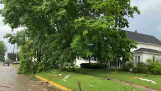
Columbia Report: Lakeview subdivision has damage and trees down. A couple of homes in the area as well as businesses, received damage., Per EM
- Moderator
- #194

Mesoscale Discussion 0090
NWS Storm Prediction Center Norman OK
0511 PM CST Wed Feb 12 2025
Areas affected...southeast MS and southwest AL
Concerning...Tornado Watch 5...6...
Valid 122311Z - 130045Z
The severe weather threat for Tornado Watch 5, 6 continues.
SUMMARY...Primary tornado threat will persist near the warm front,
especially with discrete/semi-discrete supercells that cross/remain
anchored along it. A strong tornado is possible.
DISCUSSION...Several supercells have occurred over the past hour,
mainly from parts of south-central MS into southwest AL. The
environment will remain quite conductive to low-level rotation,
especially near/along the wavy west/east-oriented warm front that
extends roughly from Simpson County, MS to Montgomery County, AL.
Discrete and semi-discrete supercells that can continue to
regenerate across eastern LA into southeast MS will be the most
likely candidates for eventually sustaining a longer-lived tornado
as they impinge on the vorticity-enriched warm front. Overall setup,
with peak STP having increased to a 3 as of 22Z, should favor
potential for a strong tornado.
The northern extent of the tornado threat will be limited by cooler
temperatures. Per early afternoon observed and RAP forecast
soundings, as storms move north of the 65-66 F isodrosotherm, the
tornado threat will diminish. Surface winds deeper into the warm
sector across LA are slightly veered and modulating to some extent
low-level hodograph curvature.
Justin Hindman
Member
- Messages
- 378
- Reaction score
- 1,165
- Location
- Gardendale Alabama
- Special Affiliations
- SKYWARN® Volunteer
- ARRL Member
Watching the storm near state line. Getting stronger
Jason Mills
Member
I see two possible issues that have kept us from having sustained mesocyclones:
1.) There is some veer-back-veer in the 3km ish range that is interrupting the organization of a persistent mesocyclone.
2.) The low level lapse rates are a little paltry. Stronger low-level lapse rates would improve the stretching of the updraft near the surface.
I still think we will see an uptick in tornado activity as the LLJ strengthens during the evening, especially in storms that root themselves along the warm front or an outflow boundary that was left behind this morning.
TornadoFan
Member
Chatom storm looks...interesting.
Cyclonic Paracosm
Member
