
Really hope we don't see a pink debris ball after it goes through.Debris now 6k feet in the air just south of downtown Morganfield, Kentucky.
Navigation
Install the app
How to install the app on iOS
Follow along with the video below to see how to install our site as a web app on your home screen.
Note: This feature may not be available in some browsers.
More options
-
Welcome to TalkWeather! We see you lurking around TalkWeather! Take the extra step and join us today to view attachments, see less ads and maybe even join the discussion. CLICK TO JOIN TALKWEATHER
You are using an out of date browser. It may not display this or other websites correctly.
You should upgrade or use an alternative browser.
You should upgrade or use an alternative browser.
Severe Threat May 15-16, 2025
- Thread starter CheeselandSkies
- Start date
TornadoFan
Member
Debris ball south of Morganfield.....
You jinxed it. Already a 60dbz+ debris ball just before entering.Really hope we don't see a pink debris ball after it goes through.
UpperLevelLOL
Member
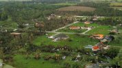
That post office looks tiny, I think that is Clear CreekIf that was in Bloomington IN, I can only imagine how awful the damage is in Clear Creak.
AJS
Member
Pink reflectivity debris ball!
Not gonna disrupt the thread too much but wasn't June 2nd super unseasonable? Pretty sure it was a very anomalous outbreak. That being said this outbreak seems like a real duplicate of june 2nd...No that's pretty bad faith from Nixon. Most conversation around this revolves around the southern plains/I-35 corridor in OK and KS, which is the area that storm chasers would prefer to be and has been a while without a major daylight outbreak.
The best analogy for this outbreak might be June 2 1990, which did produce many highly visible tornadoes in pretty much the same area. The other would be March 2 2012.
tornado examiner
Member
Not again.. good grief. Is this the 5th or 6th today?You jinxed it. Already a 60dbz+ debris ball just before entering.
Welp...Really hope we don't see a pink debris ball after it goes through.
Well...Really hope we don't see a pink debris ball after it goes through.
Ozonelayer
Member
I feel like a broken record, this one is violent aswell...
UpperLevelLOL
Member
Drillbit in Morganfield 

TornadoFan
Member

warneagle
Member
big debris ball. morganfield isn't a tiny town either, 3,200 people. bad bad bad bad bad.
UpperLevelLOL
Member
NWS chat: TORE for Morganfield being considered
Kds86z
Member


TornadoFan
Member
who's stream?Drillbit in Morganfield View attachment 41955