Navigation
Install the app
How to install the app on iOS
Follow along with the video below to see how to install our site as a web app on your home screen.
Note: This feature may not be available in some browsers.
More options
-
Welcome to TalkWeather! We see you lurking around TalkWeather! Take the extra step and join us today to view attachments, see less ads and maybe even join the discussion. CLICK TO JOIN TALKWEATHER
You are using an out of date browser. It may not display this or other websites correctly.
You should upgrade or use an alternative browser.
You should upgrade or use an alternative browser.
Severe Threat May 15-16, 2025
- Thread starter CheeselandSkies
- Start date
Central Ohio Wx
Member
Loyal might was in the path of that 
Let's hope we don't get any significant damage and/or casualties out of that area.Loyalmightwas in the path of that
US_Highway15
Member
Kds86z
Member
Gotta let my sister in Rockford know..Tornado Watch has been issued for the Chicagoland area.
View attachment 41684
Kds86z
Member
Tornado Otg up in NW Mn
US_Highway15
Member
NWS in Chicago/Romeoville is confident in the tornado risk increasing at 8 PM CDT approaches:
NEW AFD:
"MESOSCALE...
Issued at 520 PM CDT Thu May 15 2025
Quick update...
Environment across northern IL remains not terribly favorable
for tornadoes with high LCLs and fairly marginal low level
shear. It still appears that low level jet will quickly ramp up
between 23z-01z, which should result in a significant increase
of low level shear. By 01z, large, looping 0-1km hodographs
become quite favorable for stronger low level mesocyclones and
tornadoes. We should also see a diurnal decrease in the T/Td
spreads with gradually lowering LCL heights. So expecting the
environment to become increasingly favorable for tornadoes early
this evening.
Eastward progression of storms has been slower than earlier CAM
guidnace had suggested. Originally, it was looking like the
storms would be pushing into northwest Indiana as the
environment was improving for tornadoes, however with the slower
eastward progression of storms, a larger portion of our CWA
could have supercells in the area as the environment grows more
favorable for tornadoes. At this time, it looks like roughly
along and south/east of I-55 could see the greatest tornado
risk.
Any supercell that does develop could produce very large hail,
potentially up to 3 inches in diameter as well as locally
damaging winds across the entire area."
Kds86z
Member
Watching that tornado warning near Columbus Wisconsin
Kds86z
Member
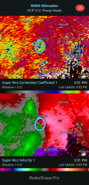
Tornado warned storm east of Columbus Wisconsin actually has a tight couplet. I'm wondering if there's a weak tornado down.
CC is a bit cluttered due to the hail so can't make heads or tails on that
CC is a bit cluttered due to the hail so can't make heads or tails on that
Looks like potentially a Debris ball north of jeauna.
**Yep tornado on the ground!
**Yep tornado on the ground!
Kds86z
Member
Wow first of the event..Looks like potentially a Debris ball north of jeauna.
**Yep tornado on the ground!
Kds86z
Member
Central Ohio Wx
Member
Because it didn't meet the criteria for a PDS warning.Good grief. How has this not gone PDS yet?


