Certainly is concerning to see HRRR, NAM3k and RRFS all favoring clusters of discrete and semi-discrete cells developing through the MS and OH river valleys tomorrow afternoon/evening.
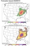
The synoptic pattern becomes pretty impressive between 21-00z with a slightly negatively tilted shortwave emerging out of the area of westerly flow that brings today's severe weather. While the broader trough is moving pretty slowly, the speed max which ejects out of Oklahoma 12z tomorrow and ends up in C IL as pictured below by 00z is moving roughly 50kts, above the 40kt threshold from OMEGA. So that's interesting.

Your aren't really going to get much more zonal than that with the trough not being overly amplified though is close enough to the warm sector to provide broad synoptic scale lift. In theory this would support (semi) discrete supercells for at least a time, and there are a couple events which produced significant outbreaks with a similar trough geometry to this.
That being said models display somewhat of a boundary representing the deep moisture. Not quite a warm front imo given there is no thermal change or wind shift, but some sort of boundary nonetheless. Where we get to get storm development along this boundary - parallel to the mid level flow, it's not hard to see a derecho/or MCS become the primary storm mode. Though even if this does occur I'm sure a mixed mode would be possible, at least early on.

Now if any sustained discrete supercell can mature in the warm sector, that will undoubtedly cause trouble.

Forecast profiles from almost all models suggest a very favorable environment for strong/intense tornadoes - even as early as 19/20z, which is less common this time of year when you typically rely on the nocturnally increasing LLJ.
I don't want to run in guns blazing like I did for the last setup (and we know how that turned out haha) but certainly the ingredients are there for a significant, higher end tornado event tomorrow. The question is to what extent do they come together?
The synoptic pattern becomes pretty impressive between 21-00z with a slightly negatively tilted shortwave emerging out of the area of westerly flow that brings today's severe weather. While the broader trough is moving pretty slowly, the speed max which ejects out of Oklahoma 12z tomorrow and ends up in C IL as pictured below by 00z is moving roughly 50kts, above the 40kt threshold from OMEGA. So that's interesting.
Your aren't really going to get much more zonal than that with the trough not being overly amplified though is close enough to the warm sector to provide broad synoptic scale lift. In theory this would support (semi) discrete supercells for at least a time, and there are a couple events which produced significant outbreaks with a similar trough geometry to this.
That being said models display somewhat of a boundary representing the deep moisture. Not quite a warm front imo given there is no thermal change or wind shift, but some sort of boundary nonetheless. Where we get to get storm development along this boundary - parallel to the mid level flow, it's not hard to see a derecho/or MCS become the primary storm mode. Though even if this does occur I'm sure a mixed mode would be possible, at least early on.
Now if any sustained discrete supercell can mature in the warm sector, that will undoubtedly cause trouble.
Forecast profiles from almost all models suggest a very favorable environment for strong/intense tornadoes - even as early as 19/20z, which is less common this time of year when you typically rely on the nocturnally increasing LLJ.
I don't want to run in guns blazing like I did for the last setup (and we know how that turned out haha) but certainly the ingredients are there for a significant, higher end tornado event tomorrow. The question is to what extent do they come together?