warneagle
Member
I've seen this movie before. I remember how this ends.18z NAM has a monstrous long tracked supercell on Friday initiating in MO and tracking through the afternoon into KY along the Ohio River.
Follow along with the video below to see how to install our site as a web app on your home screen.
Note: This feature may not be available in some browsers.
I've seen this movie before. I remember how this ends.18z NAM has a monstrous long tracked supercell on Friday initiating in MO and tracking through the afternoon into KY along the Ohio River.
I think most of us have, the ending was awaited but it honestly seemed like it never came. To be fair, I doubt we will have another Mayfield-like tornado for a while.I've seen this movie before. I remember how this ends.
Agreed. this isn’t hyperbole but there’s a much higher chance of a super outbreak occurring again before we get a confirmed 160+ mile tornadoI think most of us have, the ending was awaited but it honestly seemed like it never came. To be fair, I doubt we will have another Mayfield-like tornado for a while.
Especially of the intensity of said 160+ mile nado.Agreed. this isn’t hyperbole but there’s a much higher chance of a super outbreak occurring again before we get a confirmed 160+ mile tornado
I still can’t believe the Mayfield Tornado even happened. It felt like an EAS scenario type event. Truly unreal to still think about to this day.Agreed. this isn’t hyperbole but there’s a much higher chance of a super outbreak occurring again before we get a confirmed 160+ mile tornado
Same story for the MPAS-RT and the new MPAS-G:For what it's worth, the RRFS has a somewhat similar idea to the nam3k for thurs evening: View attachment 41377


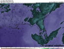
It's a weird setup down in these parts. I'm used to February/March/April systems and all their complications, but this one poses different forecasting challenges. There's a chance no one in MS/AL/GA will see even a drop from anything other than a shower during the day Friday, but if even one storm were to take root, it could become quite dangerous. Even with somewhat unidirectional shear, the strong instability could account for it.12z Euro is still very aggressive Friday evening across North MS as far as Dewpoint and CAPE values. Bulk shear is lower, but increases thereafter.
All times valid at 7pm Friday.
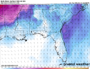
Would not surprise me in the least if we see that current Slight Risk at Day 4 expand further south and east/west with potential for a Enhanced Risk within the Slight Risk area. Tornado threat overall dependent upon storm mode, but a tornado threat WILL BE there.

My prediction is 50/50 it could go either way.,Either this is going to be a bu$T in the end, or we will be throttling here in a few days.
May’s gone up the ladder halfway and has to decide whether to go up further (a big storm system like this one coming up possibly) or go down the ladder again (trend down the threat hopefully)


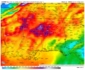
Box-averaged RAP sounding (almost forgot I could do those now I've finally forked over for Pivotal Plus) for southern WI at 21Z Thursday:
Very interesting that one analog date is quite notorious and the other is...in late July.
Here's one valid for an hour later: