notsoencrypted
Member
- Messages
- 325
- Location
- Dane County, WI
Friday is definitely intriguing to me. The 3CAPE is so pitiful just because of the cap in place, but if that were to erode that’s certainly a good looking thermodynamic profile for this area.Pulled this interesting sounding off the 18z GFS on the Ohio River, practically in the middle of the Indiana-Kentucky border for Friday. Solid curvature in the low levels with a cap in place, and take a look at the analogs there - April 4th 1974. On the other hand, 3CAPE levels are really quite pitiful. This is a very cherry picked sounding, so take it as you will:
View attachment 41322
Dayton had Xenia and Cinci had Syler Park, both F5s as wellFriday is definitely intriguing to me. The 3CAPE is so pitiful just because of the cap in place, but if that were to erode that’s certainly a good looking thermodynamic profile for this area.
One thing on the 4/3/74 sounding, it’s MGM (Montgomery, Alabama). Montgomery was outside of the main action that day and the best upper level support and parameters were off to the north. The alarm bells should start ringing if you see a 4/3/74 BNA or DAY sounding. Those are Nashville and Dayton respectively. Independent of that, it still does show a pretty good thermodynamic profile.
I’m right in Lynchburg with you buddy.I believe we have. I live near Lynchburg.
Unless we have a MCS form Thursday night and that continues into Friday morning, travel should be fine from Friday morning thru late Friday afternoon (3pm). After 3pm is when things should start popping for North AL into Tennessee. Not sure about Kentucky or Indiana.Me and my mom plan to leave midday Friday from Huntsville, Alabama after my morning job is over and drive I-65 north and spend the night halfway between Louisville and Indianapolis and finish driving to northern Michigan for a vacation. What is the threat looking like for the I-65 corridor Friday in Tennessee and Kentucky and southern Indiana? I’m trying to decide if I need to take extra time off for Friday and leave in the morning to try and beat the storms.
I agree that it’s uptrending at a substantial rate, but I’d hold off for just a little longer before we really sound off the alarm bells. There’s still a lot of questions that will certainly be answered in the coming days before the event kicks off.Looks like the dew points along the dryline Thursday have backed off in TX, OK, and MO, but the set up is looking as potent as ever for the midwest and Ohio Valley..
Middle Tennessee is looking like the furthest south threat Friday, with west Tennessee still looking to get in on the action
View attachment 41327View attachment 41328
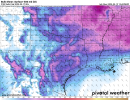
Kentucky is also looking ugly. The tornado threat is so high even with lower dew points partially due to the wet bulb temps (blue line) helping the surface air rapidly and easily saturate as it evaporates. The wet bulb temp will also act as a proxy for rapid cooling and condensation of air in the dry region and help strengthen updrafts and downdrafts, . It will essentially helps rising air reach free convection without excessive drying.
View attachment 41329View attachment 41330
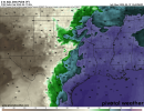
Southern Indiana (first Pic) and Illinois (2nd Pic) are just as tornadic
View attachment 41340View attachment 41341
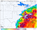
Lastly, a potent sounding from the Kansas City area and the sharp, aggressive dryline behind the whole shebang.
View attachment 41342View attachment 41343
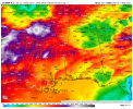
View attachment 41344View attachment 41345
I'll be the first to say it. This has widespread tornado outbreak written all over it. An extremely potent one at that. I feel confident saying it, even after what happened on April 2nd because the models are showing far more isolated convection than they ever did for April 2nd. Even the GFS is showing it in ways I haven't seen all year.
I agree that it’s uptrending at a substantial rate, but I’d hold off for just a little longer before we really sound off the alarm bells. There’s still a lot of questions that will certainly be answered in the coming days before the event kicks off.
Also, we’ve seen it time and time again - things looking insanely potent up till the event fully starts, then the smallest mesoscale details prevent it from becoming a full fledged monster outbreak - 3/15/25 is a perfect example of this even though the high risk still verified, as the crapvection did end up saving us that day from an even more significant outbreak. Also the b-word from 4/28 was pretty nuts to see, although there were concerns leading up to that event, to be fair. A 5/3/99 analog is quite something though. I’m starting to believe somewhere is going to see some significant tornadic activity on Friday, whether it’s super cellular or QLCS driven.
Living in Columbus my whole life, I’m used to the worst weather always finding a way to b-word here (outside of the June 2012 derecho that flung my trampoline 100 yards away from my backyard and wrecked it, lol) so it’s always eyebrow raising to me to see such consistency in supercell composite being modeled here, it catches my attention.
I was literally about to post this. I thought I was seeing things for a second, but that's literally the Moore 1999 tornado. Not gonna lie, I cannot recall a time (definitely recent in the past several years or even decade) where I've seen STP values this high for my hometown and neighboring areas. Definitely a daunting feeling I haven't experienced before.![]()
Sounding from northern Indiana on 03z Friday. Via the 00z NAM. No sure about you but...that analog.....Hate to see that on there.
Pulled this interesting sounding off the 18z GFS on the Ohio River, practically in the middle of the Indiana-Kentucky border for Friday. Solid curvature in the low levels with a cap in place, and take a look at the analogs there - April 4th 1974. On the other hand, 3CAPE levels are really quite pitiful. This is a very cherry picked sounding, so take it as you will:
View attachment 41322