OHWX97
Member
That was a devestating hit.


Follow along with the video below to see how to install our site as a web app on your home screen.
Note: This feature may not be available in some browsers.


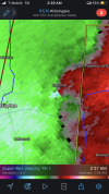
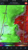
Yeah not a fan of that. It’s gonna slowly drift towards the Dayton metro overnight. Just let my parents know to keep their phone ringers on so I can call them if it hits the fan later.Don't like the look of the storm heading into the southern portions of the Indianapolis metro. Fortunately not a horrifically tight couplet, but definitely hooking.
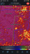
If we're seeing what looks to be high end EF2+ damage already, I dread what daylight is going to reveal...First damage pics trickling in from Grand Blanc. Every bit as bad as I had feared unfortunately. Already hearing about a possibile fatality too. Not good…
View attachment 24030
The pic was from freaking Andover…why do people do this?If we're seeing what looks to be high end EF2+ damage already, I dread what daylight is going to reveal...
edit: Hmmm, was gonna reverse image search it. Still, the Grand Blanc tornado was undoubtedly significant.

They want to be the "first one" who shared damage imagery from a tornado. It's a social media badge of honor that they did so before anyone else. All one has to do is grab any image that looks "close enough" and use it to decorate their post, but hurry before someone who actually knows what they're talking about beats them to it.The pic was from freaking Andover…why do people do this?
There was some other damage from last August that was posted on social media today as well. I apologize for sharing this bs.