
Navigation
Install the app
How to install the app on iOS
Follow along with the video below to see how to install our site as a web app on your home screen.
Note: This feature may not be available in some browsers.
More options
-
Welcome to TalkWeather! We see you lurking around TalkWeather! Take the extra step and join us today to view attachments, see less ads and maybe even join the discussion. CLICK TO JOIN TALKWEATHER
You are using an out of date browser. It may not display this or other websites correctly.
You should upgrade or use an alternative browser.
You should upgrade or use an alternative browser.
Severe Threat August 7-9
- Thread starter Atlantic
- Start date
Kds86z
Member
joshoctober16
Member

man that spiral in canada.
Kds86z
Member
Kds86z
Member
Kds86z
Member
Kds86z
Member
Kds86z
Member
CheeselandSkies
Member
Tomorrow has gotten a bit more interesting locally. Still not expecting much more than outflow-dominant clusters/lines, but the 1730Z did add a 2% tornado contour in the Midwest. The main problem with this setup is the best forcing and bulk shear lagging behind the cold front, which is fairly common in the summer.
Kds86z
Member
Kds86z
Member
CheeselandSkies
Member
Already over an hour later and not much on the radar. There was recently a funnel cloud report in Swift County, MN with what looks like nothing more than a shower (although to be fair, it's in such a radar hole you can't see what's going on below 10,000').
Kds86z
Member
Yeah I know right? Lol it’s now 8pm…Already over an hour later and not much on the radar. There was recently a funnel cloud report in Swift County, MN with what looks like nothing more than a shower (although to be fair, it's in such a radar hole you can't see what's going on below 10,000').
Kds86z
Member
Kds86z
Member
Well finally…
KakashiHatake2000
Member


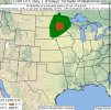
well supposed to be a map for upper midwest but its not show up but some of them showing a cap an eml and also fat instability
Last edited:
Kds86z
Member
“
SCATTERED TO WIDESPREAD STORM DEVELOPMENT IS STILL EXPECTED LATER
THIS EVENING FROM THE FAR EASTERN DAKOTAS INTO MN, AS A SEASONABLY
DEEP MID/UPPER-LEVEL SHORTWAVE TROUGH AND ATTENDANT COLD FRONT
IMPINGE UPON A STRONGLY UNSTABLE ENVIRONMENT. A FEW SUPERCELLS COULD
EVOLVE INITIALLY WITHIN A MODERATELY SHEARED ENVIRONMENT, WITH A
THREAT OF HAIL AND POSSIBLY A TORNADO. DEEP-LAYER FLOW/SHEAR
GENERALLY PARALLEL TO THE FRONT WILL LIKELY RESULT IN A QUICK
TRANSITION TO A CLUSTER OR LINEAR MODE. THIS COULD LEAD TO AN
INCREASING THREAT FOR DAMAGING WIND, THOUGH THERE MAY BE SOME
TENDENCY FOR CONVECTION TO BECOME SLIGHTLY ANAFRONTAL WITH TIME”