• Welcome to TalkWeather!
    We see you lurking around TalkWeather! Take the extra step and join us today to view attachments, see less ads and maybe even join the discussion.
    CLICK TO JOIN TALKWEATHER

Severe Risk/Excessive Heat 7/27-7/28/2026

While supercells may be more messy in nature today, i think it's always important to watch for more discrete nature in these cases. Remember last week's surprise outbreak in the Ohio Valley?

There is a awful lot of low level instability that can be stretched vertically today. We seen what extreme instability can do yesterday. hrrr_2026072812_006_37.01--81.90.png
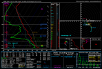
E KY/S WV/SW VA in particular I'm watching.
 
I’m amazed at the number of Tornado Warnings that are occurring in Severe Thunderstorm Watches this summer. There is a Tornado Warning near Lewisburg, West Virginia.


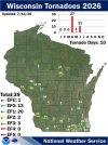
All of them rather far north, as well. This map is from July 13th, so it doesn't have yesterday's. That EF3 would be roughly on the same latitude as No. 12, on the northern tip of Lake Winnebago (the large dark spot north of tornado No. 31).

745952898_2521376688299884_6345369960519604859_n.jpg


Just learned about a new phenomenon called meteotsunamis. They're tsunamis caused by rapid changes in atmospheric pressure, and one occured yesterday with the Appleton tornado. Pretty crazy!


Just learned about a new phenomenon called meteotsunamis. They're tsunamis caused by rapid changes in atmospheric pressure, and one occured yesterday with the Appleton tornado. Pretty crazy!


Lake Winnebago has had them before related to severe weather phenomena. In June of 2001 a derecho (for which SPC had issued a high risk, back when 45% hatched for wind was enough to trigger it) did something similar.
 
Back
Top