• Welcome to TalkWeather!
    We see you lurking around TalkWeather! Take the extra step and join us today to view attachments, see less ads and maybe even join the discussion.
    CLICK TO JOIN TALKWEATHER
Logo 468x120

Hurricane Sam

Brice Wood

Member
Messages
295
Reaction score
181
Location
Virginia
Sea surface temperatures are gonna be at least 82F for this system, there’s gonna be little to no wind shear anytime soon that’s gonna be holding this thing back from being a cat3+ hurricane.
 

warneagle

Member
Messages
3,729
Reaction score
3,208
Location
Arlington, VA
Special Affiliations
  1. SKYWARN® Volunteer
Well this accelerated quickly. It could be a hurricane tomorrow and a major hurricane by Sunday.

145652_5day_cone_no_line_and_wind.png
 

WesL

"Bill, I'm talkin' imminent rueage"
Staff member
Administrator
Moderator
Sustaining Member
Messages
3,344
Reaction score
2,614
Location
Fayetteville, AR
Special Affiliations
  1. SKYWARN® Volunteer
Hurricane Sam Advisory Number 7
NWS National Hurricane Center Miami FL AL182021
500 AM AST Fri Sep 24 2021

...SAM IS NOW A HURRICANE...
...RAPID INTENSIFICATION FORECAST TO CONTINUE...


SUMMARY OF 500 AM AST...0900 UTC...INFORMATION
----------------------------------------------
LOCATION...11.5N 42.2W
ABOUT 1470 MI...2365 KM ESE OF THE NORTHERN LEEWARD ISLANDS
MAXIMUM SUSTAINED WINDS...75 MPH...120 KM/H
PRESENT MOVEMENT...W OR 280 DEGREES AT 15 MPH...24 KM/H
MINIMUM CENTRAL PRESSURE...993 MB...29.33 INCHES


WATCHES AND WARNINGS
--------------------
There are no coastal watches or warnings in effect.


DISCUSSION AND OUTLOOK
----------------------
At 500 AM AST (0900 UTC), the center of Hurricane Sam was located
near latitude 11.5 North, longitude 42.2 West. Sam is moving toward
the west near 15 mph (24 km/h) and this motion is expected to
continue through tonight. A decrease in forward speed and a motion
toward the west-northwest are expected over the weekend.

Maximum sustained winds have increased to near 75 mph (120 km/h)
with higher gusts. Rapid intensification is forecast to continue,
and Sam is likely to become a major hurricane tonight or early
Saturday.

Hurricane-force winds extend outward up to 15 miles (30 km) from the
center and tropical-storm-force winds extend outward up to 60 miles
(95 km).

The estimated minimum central pressure is 993 mb (29.33 inches).

083327_5day_cone_no_line_and_wind.png

storm_18_ens.gif
 
Last edited:

TH2002

Member
Sustaining Member
Messages
3,116
Reaction score
4,677
Location
California, United States
Special Affiliations
  1. SKYWARN® Volunteer
Oh boy it's another Cape Verde hurricane. Obviously it's far too early to tell, but Sam could outpace Large Larry in terms of impact and intensity.
 

WesL

"Bill, I'm talkin' imminent rueage"
Staff member
Administrator
Moderator
Sustaining Member
Messages
3,344
Reaction score
2,614
Location
Fayetteville, AR
Special Affiliations
  1. SKYWARN® Volunteer
Hurricane Sam Advisory Number 8
NWS National Hurricane Center Miami FL AL182021
1100 AM AST Fri Sep 24 2021

...SAM TAKING A MOMENTARY PAUSE IN STRENGTHENING...
...RAPID INTENSIFICATION FORECAST TO RESUME SOON...


SUMMARY OF 1100 AM AST...1500 UTC...INFORMATION
-----------------------------------------------
LOCATION...11.8N 43.7W
ABOUT 1365 MI...2200 KM ESE OF THE NORTHERN LEEWARD ISLANDS
MAXIMUM SUSTAINED WINDS...75 MPH...120 KM/H
PRESENT MOVEMENT...W OR 280 DEGREES AT 14 MPH...22 KM/H
MINIMUM CENTRAL PRESSURE...993 MB...29.33 INCHES


WATCHES AND WARNINGS
--------------------
There are no coastal watches or warnings in effect.


DISCUSSION AND OUTLOOK
----------------------
At 1100 AM AST (1500 UTC), the center of Hurricane Sam was located
near latitude 11.8 North, longitude 43.7 West. Sam is moving just
north of due west near 14 mph (22 km/h) and this motion is expected
to continue through tonight. A decrease in forward speed and a
motion toward the west-northwest are expected over the weekend.

Maximum sustained winds remain near 75 mph (120 km/h) with higher
gusts. Rapid intensification is forecast to resume over the next
several days and Sam is likely to become a major hurricane on
Saturday.

Hurricane-force winds extend outward up to 15 miles (30 km) from the
center and tropical-storm-force winds extend outward up to 60 miles
(95 km).

The estimated minimum central pressure is 993 mb (29.33 inches).
 

bjdeming

Member
Sustaining Member
Messages
1,512
Reaction score
1,231
Location
Corvallis, Oregon
So...ERCs don't just come with intense hurricanes!


last24hrs.gif


From current NHC discussion:

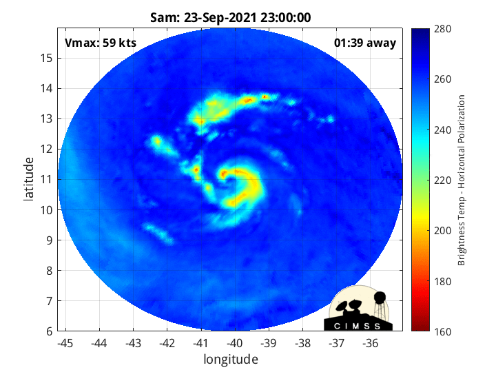
The only fly in the ointment is the current concentric banding structure on
microwave imagery, which hints at the possibility of an eyewall replacement cycle. Assuming the smaller eye will not collapse in the short term, rapid intensification appears likely over the next 12-24 hours and the intensity has been raised in the short term, taking Sam to major hurricane intensity by tomorrow.
 

TH2002

Member
Sustaining Member
Messages
3,116
Reaction score
4,677
Location
California, United States
Special Affiliations
  1. SKYWARN® Volunteer
Sam now has 140 mph sustained winds and an incredible structure. Looks like it's still intensifying too.
 
Back
Top