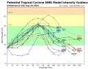
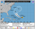
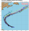
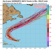
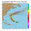
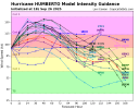
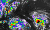
This storm is going boom, just like the other hurricanes did this year. It’s becoming a scary trend and it’s a little hard not to attribute these sorts of things to climate change. I genuinely think Humberto is going to hit 160+ now.Major Hurricane Humberto is now forecast to peak at 130 kts (150 mph) according to the NHC, and I won’t be surprised if Humberto manages to become a Category 5 and outperform the forecast as it has continued to do.
Navigation
Install the app
How to install the app on iOS
Follow along with the video below to see how to install our site as a web app on your home screen.
Note: This feature may not be available in some browsers.
More options
-
Welcome to TalkWeather! We see you lurking around TalkWeather! Take the extra step and join us today to view attachments, see less ads and maybe even join the discussion. CLICK TO JOIN TALKWEATHER
You are using an out of date browser. It may not display this or other websites correctly.
You should upgrade or use an alternative browser.
You should upgrade or use an alternative browser.
Potential Tropical Cyclone Nine and Hurricane Humberto
- Thread starter wx_guy
- Start date
And I saw the EURO run earlier this morning that bombed Humberto down to 914 mbThis storm is going boom, just like the other hurricanes did this year. It’s becoming a scary trend and it’s a little hard not to attribute these sorts of things to climate change. I genuinely think Humberto is going to hit 160+ now.
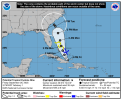
The NHC has just been initiated advisories on AL94 as PTC Nine, so I think it’s time for this thread to be created.
| 000 WTNT34 KNHC 262040 TCPAT4 BULLETIN Potential Tropical Cyclone Nine Advisory Number 1 NWS National Hurricane Center Miami FL AL092025 500 PM EDT Fri Sep 26 2025 ...TROPICAL STORM WATCHES AND WARNINGS ISSUED FOR PORTIONS OF THE BAHAMAS... SUMMARY OF 500 PM EDT...2100 UTC...INFORMATION ---------------------------------------------- LOCATION...20.9N 74.6W ABOUT 55 MI...90 KM NNW OF THE EASTERN TIP OF CUBA ABOUT 200 MI...325 KM SSE OF THE CENTRAL BAHAMAS MAXIMUM SUSTAINED WINDS...35 MPH...55 KM/H PRESENT MOVEMENT...NW OR 305 DEGREES AT 9 MPH...15 KM/H MINIMUM CENTRAL PRESSURE...1008 MB...29.77 INCHES |
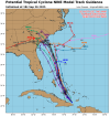
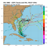
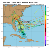
12Z ECMWF - Forms Imelda closer to the coast, but Humberto pulls Imelda, much weaker, up the FL coast, further out to sea through 87...
Last edited:
I have initiated a thread for PTC Nine if you are interested in posting there as well.12Z Euro developing Imelda closer to FL coast... will be an interesting run.
OK, will move discussion of PTC9/Imelda over there. 12Z ECMWF run is yet another completely new scenario.
Multiple scenarios plausible with this one. The fujiwhara with Humberto is going to make this a weird one to watch.
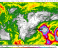
12Z ECMWF today - develops slowly off FL coast, tightens up right before mid SC coastline, takes a hard LEFT (yes, you read that right), looping counterclockwise riding the coast. Stalls at the mouth of the Savannah river. Sits there. Strengthens. AWFUL scenario. Has other models supporting the general idea though. Then landfall on GA coast, inland into N GA.
That happens? It rains in SC for days. 2 feet of rain.

Last edited:
Kds86z
Member
- Thread starter
- #91
wx_guy
Member
- Messages
- 1,193
- Reaction score
- 4,277
- Location
- United States
- HAM Callsign
- KO4ZGH
- Special Affiliations
- SKYWARN® Volunteer
- ARRL Member
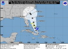
It's an important reminder (and maybe a new lesson for some of you) that the Cone is NOT a dynamic predictor of uncertainty. Meaning it does NOT factor in storm-specific measures of uncertainty. Instead, at the beginning of the year (2025 in this case), the NHC sets the widths of the Cones for the entire year based on the last 5 years of average errors so that about 2/3 of the time, the storm falls inside the Cone. In other words, there's about a 1/3 chance the storm goes outside the Cone at any point in the future AND that's only if it's "average" errors. The NHC has mentioned that uncertainty in the future path of Imelda is *considerably* higher than usual because of the Fujiwhara possible interactions and possibly weaker steering currents. Therefore, the Cone in this case should be taken with MUCH more grain of salt than usual.
Essentially, anywhere from Florida to North Carolina (or no one at all, even, if it goes further east) could be future targets of this storm.
Let the game begin...
Essentially, anywhere from Florida to North Carolina (or no one at all, even, if it goes further east) could be future targets of this storm.
Let the game begin...

- Admin
- #93
- Messages
- 2,296
- Reaction score
- 1,892
- Location
- Meridianville, Al
- Special Affiliations
- SKYWARN® Volunteer
I've moved a bunch of posts to this thread.
Kds86z
Member
Kds86z
Member
Kds86z
Member
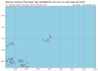
Dvorak is up to T#6.0 on Humberto now at least. It’s likely a Category 4 now.
————————————————————
————————————————————
| Analysis | |
| UW - CIMSS ADVANCED DVORAK TECHNIQUE ADT-Version 9.1 Tropical Cyclone Intensity Algorithm ----- Current Analysis ----- Date : 26 SEP 2025 Time : 221019 UTC Lat : 22:07:47 N Lon : 58:15:35 W CI# /Pressure/ Vmax 6.0 / 947.4mb/115.0kt Final T# Adj T# Raw T# 6.0 6.3 6.4 Estimated radius of max |
Someone smarter than me tell me what the limiting factor is that keeps Imelda a lower-end storm. Humberto? It's not moisture, water temps or TCHP. Shear from Humberto?
When I see the HRRR showing this, where it is showing it, with the water temps at depth under it, with a closed circulation, I think off to the races, not tropical storm for 2 days. That is untapped bath water.
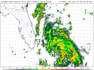
When I see the HRRR showing this, where it is showing it, with the water temps at depth under it, with a closed circulation, I think off to the races, not tropical storm for 2 days. That is untapped bath water.

Last edited:
Psalm 148:8
Member
Latest from Parris Island.. my nephew is a marine drill instructor.. they have decided to stay with recruits and ride out the storm.. my niece and great nephew will decide on Monday whether or not they will evacuate. They live on the base.Yall keep the info coming., got a niece and family at Parris Island, SC.. she said they may have to evacuate.. did not hear where she got this info.. edit.. military planning dept. monitoring the storms.

