• Welcome to TalkWeather!
    We see you lurking around TalkWeather! Take the extra step and join us today to view attachments, see less ads and maybe even join the discussion.
    CLICK TO JOIN TALKWEATHER
Logo 468x120

Nyiragongo

bjdeming

Member
Sustaining Member
Messages
1,512
Reaction score
1,231
Location
Corvallis, Oregon


This isn't your ordinary eruption scenario, for complex reasons I summed up here. (Am doing updates at that post, too.)

That's why everyone is treating this like a big news story, even though the eruption only started a few hours ago, from what I have learned thus far on Twitter.

This could get bad, really bad. Best-case scenario is that it plays out like the 2002 eruption and just trashes part of Goma. Sigh.

 
Last edited:

bjdeming

Member
Sustaining Member
Messages
1,512
Reaction score
1,231
Location
Corvallis, Oregon
This might not turn out quite such a disaster. Hope so.

Emmanuel De Merode, head of Virunga National Park, asked park employees in parts of Goma to evacuate, according a note seen by Reuters. He said lava had reached the international airport on the eastern edge of the city but that it was not likely to reach other parts of Goma.


Celestin Kasereka, head of scientific research at the Goma Volcano Observatory (OVG), told reporters he did not think the lava was flowing fast enough to reach Goma.

-- Source
 

bjdeming

Member
Sustaining Member
Messages
1,512
Reaction score
1,231
Location
Corvallis, Oregon
It stopped a few yards from the city.

“We’ve been extremely lucky that it was very brief,” said Dario Tedesco, a volcanologist based in Goma. “From the little information we have, it was just the lava within the crater that came out, there was no additional lava from below.”

-- Reuters

The Kinshasha Times reports five known direct deaths thus far, not counting accidents and other indirect fatalities. Several villages reportedly were lost, too, and from images online the thick lava really trashed the Buhene District north of Goma, even as it was slowing down and coming to a halt.
 

bjdeming

Member
Sustaining Member
Messages
1,512
Reaction score
1,231
Location
Corvallis, Oregon
I'm sorry to say that the crisis isn't over yet.

First, here's a map that VDAP (the USGS/USAID quick-response team) just released of the surface lava eruption on May 22-23. They found three vents.

e2bhoghxwaa82gs.jpeg


Okay: see the volcano (Shaheru is a flank cone; the lava lake that partly drained was up at Nyiragongo's summit), Goma and its surrounding urban area, and Lake Kivu (which contains enormous amounts of carbon dioxide and methane at depth and could explode)?
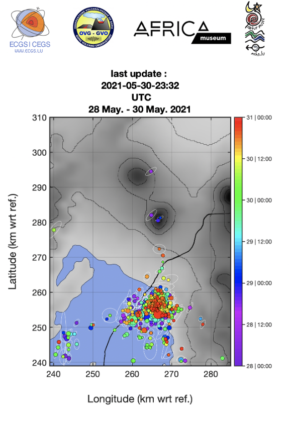
Well, per this source:

Current seismicity and ground deformation data continue to indicate the presence of magma under the Goma urban area with extension under Lake Kivu. Seismicity remains high and continues to migrate southwards and surface deformation is still recorded by the GPS network and InSAR. These observations are consistent with the continued propagation of magma at depth towards the south. Because of the partial drainage of the lava lake associated to the continuous collapse of the crater inside the summit of Nyiragongo, ash fallout may again occur. Data on the stability of Lake Kivu currently show no significant change.

-- May 27th update

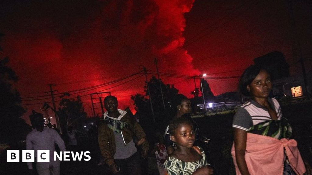
If this was almost anywhere else in the world, they would have all those millions out of harm's way.

But the Congo is really messed up. They only had their first peaceful transition of power in 2019; armed groups are fighting in the area, so earlier this month, the district that includes Goma was put under martial law; and corruption is allegedly so rampant that, according to this tweet (Twitter translation), some of those who fled on the 22nd experienced "Extortion, intimidation, theft and confiscation of money: this is what some of the displaced persons who took the road to Minova suffered. If you have 100 dollars, we ask you for "a slip", otherwise we take 10 dollars. Computers and phones stolen by Police, military and ANR agents."

MONUSCO -- the UN peacekeepers -- are doing the best they can, but that isn't much. Don't know anything about the government, but I didn't see anyone in Congolese government taking a strong, effective leadership role during or after the eruption, when those millions of people really needed it.

This is such a rough place, maybe showing initiative like that, or even just doing your job, could get you and your family killed.

Things are better in Rwanda, I think, which is also at risk in this region. They, too, have an extremely painful history, but they seem more focused and actually have a tourism industry in this UNESCO World Heritage area -- which could be great for the Congo, too, if it could get its act together. Rwandans are even mining methane VERY CAREFULLY from Lake Kivu for energy. But I've read that there's so much down there, it's not going to reduce the risk much and, again, must be done with extreme caution to avoid triggering a lake overturn (explosion).

Sorry to go on and on, but it really bothers me. Because of the urban development here, lake overturn could kill far more people than Krakatoa in 1883 and Tambora in 1815, combined, did -- in just five or ten minutes. And there is so little that can be done right now, though it's true that knowledgeable people in the Congo and around the world are working hard on it.

I read up on this while writing Nyiragongo up as a Decade Volcano. More research is needed, but experts suggest that the geologic record does show periodic overturns at Lake Kivu. However, magma flow under the land that's now occupied by Goma and the lake has been recognized before, without consequence as well as occasionally with eruption (Mount Goma, a hill in town -- near the lake, I think -- is the result of one of those eruptions; people took shelter there on May 22nd, and the volcano observatory sits there, too).

And too, after the 2002 eruption, which was even larger, there also was lots of seismicity, as there is now, although lack of instruments hindered expert understanding of what was going on down there.

This is just something that Nyiragongo does, often without terrible consequences of biblical proportion for people living nearby.

Let's hope that this is one of those times with a relatively good outcome.

Edit: Forgot to mention an excellent information source: the Smithsonian's Global Volcanism Program's Nyiragongo page. The latest report, up to the 25th, is sobering.

Also, going back on Twitter, found this video of one of Goma's districts -- makes it more than just a foreign place name. And there is the lake, right there.

 
Last edited:

bjdeming

Member
Sustaining Member
Messages
1,512
Reaction score
1,231
Location
Corvallis, Oregon
I'm still catching up, sorting out real news and rumors. This is from a reliable source, about twenty-one hours ago. This military governor has ordered ordered evacuation of some parts of Goma, including the one shown above, I think.

Reported by the same source, people are heading for the capital (Kinshasa) and another city. Per the Kinshasa Times, authorities are meeting to try to figure out where to put evacuees.

More details.


Per Twitter translation, "Let us be humble before the forces of nature. Pray for the tens of thousands of people who are suffering. May Goma and its inhabitants be spared and may this help us build a more just and peaceful world."
 
Last edited:

bjdeming

Member
Sustaining Member
Messages
1,512
Reaction score
1,231
Location
Corvallis, Oregon
Lake Kivu borders Rwanda, too, and the urban center on that side of the border is called Gisenyi. It's in Rubavu District, and the ground there has been rocking, with infrastructure damage, too. It's more difficult to get information on events there than in Goma right now. Certainly people are taking it seriously. Per this source, some are self-evacuating. A couple of useful Twitter sources are Rubavu District and Rwanda Seismic Monitor, both in the local language but Twitter translates it.
 

bjdeming

Member
Sustaining Member
Messages
1,512
Reaction score
1,231
Location
Corvallis, Oregon
Found out more in this article about what triggered the evacuation of part of Goma:

The evacuation order comes on the heels of a warning by the Goma Volcano Observatory (OVG), which monitors the pulse of Nyiragongo and the Nyamuragira volcano, 13 kilometres (nine miles) away.

In a technical note seen by AFP, the OVG said it saw worrying signs of activity by Nyiragongo that pointed to three potential outcomes.

In the first two scenarios, Nyiragongo would erupt again, sending renewed lava flows southwards towards Goma and Gisenyi, destroying buildings in their path before reaching Lake Kivu.

In both cases, the quantity of lava likely to enter the lake would not be enough to raise its deep-water temperature by at least one degrees Celsius (1.8 degrees Fahrenheit)—a key condition for a limnic eruption.


But in the worst-case scenario, lava flows from Nyiragongo would combine with volcanic activity under the floor of the lake.

This activity could take the form of a "fissural or phreato-magmatic eruption under the lake and/or a large earthquake of 6.5 or 7 magnitude," the OVG said.

In this scenario, "a limnic eruption would take place and dissolved gas in the lake's deep water would rise to the surface, especially CO2...

One of those Congolese volcanologists tweeted this (it's the rainy season there, which doesn't help evacuees at all):


Perhaps this was taken from Mount Goma in town, at the Observatory. The plume might be degassing combined, perhaps, with ongoing collapse of the former lava lake's conduit. Haven't seen any recent tweets of satellite photos yet

A quick look at Twitter this morning shows a few responsible voices like these trying to be heard over a rising storm of people wanting to convince themselves that the worst is over. The volcano is quiet; the lava lake has drained (they probably aren't likely to think right now of Kilauea's 2018 eruption after two lakes drained); the conditions they face are terrible, both physically and socially (interruption of power and water supply; theft and violence on the road and in camps; lack of preparation to receive them: possible looting back in Goma; political corruption; diseases like cholera, etc.); and they are human beings who, like everyone else, long for their homes during a crisis.

Many families, reportedly, are going back. Graphs like the one below, which shows magma rising closer to the surface, don't count for diddly with them. That's understandable but going back to Goma just now is a really bad idea.

Incidentally, this graph does show a trend towards the surface again today. (I edited this statement from mistakenly saying the magma was going down, after rereading the graph: denial of bad news is a powerful instinct ): The depth of seismic activity did drop yesterday, meaning that something from deeper levels -- magma, presumably -- is breaking rocks as it moves; now, it's fracturing rocks closer to the surface; this is not good news.)


It's a heckuva situation when a lava flow that might trash your town is the best-case scenario (#'s 1 or 2, in the OVG assessment, above). Unfortunately, there are three fresh cracks in the mountain, so a new lava lake seems unlikely, though that would be the best case.
 
Last edited:

bjdeming

Member
Sustaining Member
Messages
1,512
Reaction score
1,231
Location
Corvallis, Oregon
It's difficult to find online news during the last day and a half or so: that's actually great, because the worst hasn't happened (OVG #'s 1, 2, or 3, above).

In fact, Reuters quotes an OVG scientist saying yesterday "I don't think we will have a second eruption. The problem is the risk of fractures, but the risk is small, around 20%."

I'm only a layperson, but that seems a little too optimistic, considering that Georiska, in Belgium, reported yesterday that seismicity is still high, with magma still under the city and under Lake Kivu, although it has stopped progressing southward as it was doing.

Apparently authorities feel this way, too, as they haven't called off the evacuation of eastern Goma, though some people are returning on their own and Rwanda's government is helping them as well as supporting those who are staying put in that country.

No updates from other volcanologists or agencies I follow, so I suspect everyone might be just waiting to see if the magma down there "freezes" or comes up.

OVG doesn't issue daily reports, unfortunately, as many volcano observatories do, but reading other tweets yesterday, I learned that volcanologists did go up to Nyiragongo's summit yesterday. Satellites also monitor it, of course, though I've seen no updated images (more good news, probably), but field work is valuable, too.

Am guessing that they might be trying to find out if the ongoing collapse of Nyiragongo's former lava lake could pressurize underground magma underneath Goma and the lake, as this process did at Kilauea in 2018 (forcing even more magma out of the East Rift zone and making that Kilauea eruption larger than it otherwise would have been).

The rumor mills are active, of course. Volcanologists WEREN'T ambushed by guerrillas when they went up the mountain yesterday (and probably not by gorillas, either: hope those all survived the eruption). This morning, there was an ordinary fire of some sort on a nearby active volcano, and word went out that there was another eruption. That rumor is still circulating but is being settled.

Here's a treasure trove of what looks like real news on the situation: original French and via Google Translate. Lots of good stuff there, which I'm still working through.
 
Last edited:

KoD

Moderator
Staff member
Moderator
PerryW Project Supporter
Messages
1,380
Reaction score
697
Location
Huntsville, AL
Thanks for the updates, I've been reading your posts closely
 

bjdeming

Member
Sustaining Member
Messages
1,512
Reaction score
1,231
Location
Corvallis, Oregon
Thank you. I have a variant of storm anxiety with this volcano, after reading about this gas problem there last year, and am working through it, but also it's big news and not easily grasped because it's outside the stereotypical eruption setup that we usually read about. Figured what little I know could help a bit, especially given the possible consequences.

What I can't convey is how one can see via Twitter and news stories how the Congolese and Rwandans are helping one another. Until this, I just mostly associated this part of the world with genocide and poverty. Ugliness certainly exists, but there is so much good there, too.

Anyway, no more news today other than a M4.3 in Rwanda near the border and the lake, but here's a video interview from the 28th with one of the OVG volcanologists. In French. I barely followed it by turning captions on in the browser at YouTube and then using the browser translator; there's some close-up video of last weekend's flows, a diagram of the gas problem in Lake Kivu, and he says (I think) that they just don't know what could set off the lake eruption, so they're being cautious.

The lakes that exploded in Cameroon back in the 80s were much smaller. AFAIK, nothing the size of gas-filled Lake Kivu is known.

I think it's a whole new situation for volcanologists during the current tech era (though the geologic record, as mentioned, does suggest that the lake has erupted more than once in the past).

They talk so fast in this video, though!


MNTornadoGuy

Member
Messages
1,615
Reaction score
2,570
Location
Apple Valley, MN
Looks like there is water displacement going on in Lake Kivu. This might be either an earthquake-induced seiche or due to uplift displacing water on one side of the lake.

E2u--uKWYAYy5YW

The earthquake swarms appear to be localized under Lake Kivu right near Goma. This could mean magma is trying to find a way to the surface under the lake.
 

bjdeming

Member
Sustaining Member
Messages
1,512
Reaction score
1,231
Location
Corvallis, Oregon
It's not earthquake induced. OVG (French) and Georiska (English, but with repetition in a couple of reports) both report that seismicity is actually decreasing.

They haven't said anything about water levels, but I'm guessing from the comments to that tweet via Twitter translation, this happens in lakes all over the rift valley this time of year due to heavy April rains.

It's part of the natural process in the upper lake waters.

That said, it certainly is true that underground magma movement, and/or hydrothermal fluids and gases, can change land and water levels. It happens often at Campi Flegrei, in Naples, for instance, and was a big clue in the 1990s that Rabaul, in Papua New Guinea, was going to erupt.

And earthquakes do cause seiches.

However, if I understand the situation at Lake Kivu -- a big "if" because I'm a layperson; here's an expert with details -- if I've got it right, every human and animal around the lake would probably be dead from asphyxia before those effects happened.

It's a big natural gas field, stratified Lake Kivu is, with all the methane and CO2 contained in a deep layer of cold, stable water and mud -- not rock. Anything that shook it enough to cause a seiche or that raised the lake bed enough to displace surface waters would first break the containment, I suspect.

Brrrr!

After that scariness, I'd better add in today's relatively good news, per Georiska (with thd weird repeated text edited out):

2021-5-30: Current seismicity and ground deformation data continue to indicate the presence of magma under the urban area of Goma with an extension under Lake Kivu.

Seismicity and deformation continue. Although seismicity above baseline is still being recorded, the energy dissipated by these earthquakes continues to decrease. The location of the earthquakes and the direction of the GPS displacements indicate a halt or pause in the propagation of the magmatic intrusion towards the south. A decrease in the displacement velocities measured by the GPS network seems to confirm these observations. However, the lack of resolution of the GPS and seismological networks, linked to the presence of the lake, does not allow us to exclude a possible future migration of the intrusion towards the surface.

2021-05-29: Current seismicity and ground deformation data continue to indicate the presence of magma under the urban area of Goma with an extension under Lake Kivu. Seismicity and deformation continue. The number of earthquakes detected in 24 hours decreases slightly, as do the deformation rates. However, this decrease in the phenomenology at this stage cannot yet be interpreted as the end of activity. During phases of volcanic activity, periods of higher seismic activity often alternate with phases of lower seismicity. seismic activity often alternate with phases of lower seismicity. Seismicity above the baseline is always recorded. These observations are always consistent with the presence of magma at depth. Ash fallout may occur as a result of the collapse of parts within the crater. The stability data for Lake Kivu do not currently show any significant change (the latest available data is from 27 May 2021).

So 400,000 people still are evacuees and volcanologists are still busy. VDAP from the US is on it, too; that video above shows a French scientist, I think; and they have also brought in experts from Italy. Other countries are probably represented, too.
 
Last edited:

bjdeming

Member
Sustaining Member
Messages
1,512
Reaction score
1,231
Location
Corvallis, Oregon
This is stronger than some of the other quakes, but only one, and it's moderate: nowhere near the M6-7 that OVG mentioned in their scenarios.


Today they also tweeted the position of all detected quakes from the eruption on (see the little red triangle, in the graphic below, that's Nyiragongo?)

White centers are oldest, red are newest, but the reported decrease in energy in these recent quakes doesn't show up well.

Anyway, there's the magma!

 
Last edited:

bjdeming

Member
Sustaining Member
Messages
1,512
Reaction score
1,231
Location
Corvallis, Oregon
Not looking for hits; I just had some thoughts on the conlicting reports about Kivu's safety and got wordy in my blog update this morning on Nyiragongo. Better there than here! ;) (Link was incorrect; fixed that. )

Basically, Rwanda says it's stable; the DRC says to wait.

Personally, I'm with the rangers-- some of the world's bravest people, BTW -- on it.

 
Last edited:

bjdeming

Member
Sustaining Member
Messages
1,512
Reaction score
1,231
Location
Corvallis, Oregon
In today's Georiska report -- they're a specific team from Belgium's Royal Society, which just sent in some volcanologists (an indication, perhaps, of how serious this situation is, given that country's past history here; still, the Congolese must have invited in these scientists):

...new satellite data recorded between 25 and 31 May underline the absence of deformation on the flanks of Nyiragongo and indicate that the ground continues to deform south of the city of Goma, albeit to a lesser extent than at the beginning of the eruption. These deformations may still create or extend existing ground fractures...

Lake Kivu is directly south of Goma, so it's not clear to me where this deformation is; perhaps they can get a little information on the lake floor this way. Hope so!

Speaking of nerdy stuff, here is an ArcGIS story map, but this one is highly technical, not yet really story written in lay terms. It's a tool for working volcanologists, but it's also interesting to explore. Note that in a report from the 27th, they describe "about 10 km of fissures have been mapped and are mainly in NNE-SSW and NNW-SSE directions." (This is mapped from space; field workers must still verify it.)

Lake overturn isn't the only hazard here, though potentially the most deadly.
 
Last edited:

bjdeming

Member
Sustaining Member
Messages
1,512
Reaction score
1,231
Location
Corvallis, Oregon
Whoa. Did you know this? I didn't.

The Kivu region, once known as a champion in agriculture, the country of coffee growers and shepherds, cheese and cold cuts producers, the little Swiss of the big lake, has seen its peasant class since the discovery of black and granular powder, abandoned its habits, to indulge shovels in hand, in a frantic way , in search of black sand, the so-called coltant-tantalide colombo. A strategic metal, an important source for the production of tantalum or niobium, coltan, of which Kivu holds between 60 and 80% of world production, is very popular for the manufacture of electronic equipment but also in the aeronautical industry.

Very high-speed broadband, the digitization of data and services, the bridging of the digital divide around the world, the internet and mobile phone boom have created a huge need for coltan in the market, creating a major rush through circuit-breakers, digital giants, to the Kivu region of the Democratic Republic of Congo.

-- source, via browser translation

On more eruption-related stuff, I set aside some quiet time and read that expert paper (here's the link again) as carefully as possible. It's a really good backgrounder, and also has this:

...While five different eruptions produced lava flows that reached the lake, and two poorly described small sub-lacustrine eruptions have been mentioned in Kabuno Bay...but none caused a limnic eruption. Most lava flows that entered the bay came from far away vents and had low flow speeds because of the local topography, such that lavas had lost a significant amount of energy before entering the bay. Therefore, we postulate that the primary event that could trigger a limnic overturn of deep Kivu waters would be a major, sustained eruption on the deep lake floor (principally in the main basin and/or Kabuno Bay) that could cause an increase in deepwater temperature. Because the solubility of the dominant gases (i.e., CO2 and CH4) in the water is inversely proportional to temperature, any significant temperature increase caused by eruptive activity could result in the exsolution of the gases and the formation of gas bubbles. The
latter would reduce the density further and cause an accelerating feedback mechanism marked by increased gas exsolution. As warm water rises up to lower-pressure depths, more gases are exsolved and further reduce water density, producing a major sustained plume of lethal gas-saturated water above the eruption site and later reaching the surface causing an overturn of the lake...

That Kabuno Bay is a small part east of Goma and almost landlocked. However, it's stratified, too, and full of CO2 to within almost 30 feet of the surface, but they're doing that fountain-style degassing there that is now done in at least one of the Cameroon lakes that exploded.

In Kivu's main basin, the gas "field" starts a little over 200 feet down and extends into the bottom sediments. The lake is 1600 feet deep in parts.

The good news is that the two gases aren't close to saturation yet, and hydrostatic pressure is holding them in well.

There are just so many other hazards, too. :(
 

bjdeming

Member
Sustaining Member
Messages
1,512
Reaction score
1,231
Location
Corvallis, Oregon
This was tweeted about twenty hours ago by the lead author of that paper linked above, who apparently filmed it in either a village or one of Goma's poorer districts. Then, about two hours ago, officials announced that everyone can return, but they still need to be vigilant -- quite an understatement! This is a gamble; I hope it works (and again got wordy about it).


bjdeming

Member
Sustaining Member
Messages
1,512
Reaction score
1,231
Location
Corvallis, Oregon
So far, the gamble is paying off, though there are occasional moderate quakes under Lake Kivu, like the recent M3.9. That's within the ongoing range, though.

Some spectacular video from last Friday when experts from the Goma Observatory visited the summit. Although the May eruption went through flank vents, they need to keep a constant eye on the summit -- you can see the heavy degassing from the former lava lake site here. Dr. Balagizi has tweeted that th volcano is recharging. In 2002, it took a while for lava to return, so it's probably on the way here, too (hope it doesn't leak out of those fresh cracks!):


Per the browser translation of this news story (French), they are especially interested in the former lake crater collapse. Also, apparently there's also a false rumor going around that Nyiragongo is dead. Wishful thinking. That's some powerful degassing there.

The observatory , which has severe management problems, per news reports, has been getting lots of attention. Maybe this crisis can get that sorted out. [Edit, June 16: It just might, hopefully before Nyiragongo goes off again. This Science Magazine article, detailing the whole ugly mess, is a welcome surprise: up to now, only Reuters has covered the GVO problems, as far as I can tell, and then only the World Bank defunding due to alleged corruption; I have no idea what's going on, which allegations are true, which aren't, but it looks to me like international scientists, at least on individual levels (and particularly Americans), are shining light in, in hopes of clearing up the situation and getting a functioning Congolese/international observatory going -- that is amazing, and a measure of how serious the volcanic threat here is, because they're risking their jobs, too, even speaking anonymously.]

Eruptions, possibly within Goma, are bad enough, but Kivu is a ticking bomb. :(
 
Last edited:
Back
Top