• Welcome to TalkWeather!
    We see you lurking around TalkWeather! Take the extra step and join us today to view attachments, see less ads and maybe even join the discussion.
    CLICK TO JOIN TALKWEATHER

Nora

TH2002

Member
Sustaining Member
Messages
3,116
Reaction score
4,677
Location
California, United States
Special Affiliations
  1. SKYWARN® Volunteer
When it comes to meteorology, history tends to repeat itself in curious ways and we'll soon find out if that's the case with Tropical Storm (very likely soon to be Hurricane) Nora.
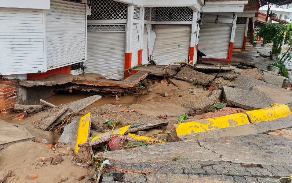
As of now the tropical storm has sustained winds of 65 mph (NHC) lashing the western coast of Mexico. The storm is forecast to move slightly NW as it makes its way up the coast for a potential rare landfall in Baja California. The cone of uncertainty currently extends into extreme southern Arizona and the storm's remnants could potentially bring thunderstorms and heavy rain to the southwest.

The storm is forecast to take an eerily similar track to Hurricane Nora (1997) which reached Arizona as a tropical storm and whose remnants brought strong winds, heavy rain and flooding to the area. If Nora (2020) does the same the heavy rainfall would certainly help with the ongoing drought and wildfires but not so much with the flooding.
 

TH2002

Member
Sustaining Member
Messages
3,116
Reaction score
4,677
Location
California, United States
Special Affiliations
  1. SKYWARN® Volunteer
Nora has strengthened further and now has 80 mph sustained winds. NHC says the hurricane is expected to continue strengthening through tonight so the storm could reach Category 2 intensity. According to the latest advisory rainfall from Nora could spread further north from the southwest into the Rockies.
 
Last edited:

TH2002

Member
Sustaining Member
Messages
3,116
Reaction score
4,677
Location
California, United States
Special Affiliations
  1. SKYWARN® Volunteer
The hurricane seems to be fluctuating in intensity with 80-85 mph winds and is nearing the coast for a possible brief landfall in the Mexican state of Jalisco, where a Hurricane Warning is in effect. The field of Nora's tropical storm force winds is also very impressive.
 

TH2002

Member
Sustaining Member
Messages
3,116
Reaction score
4,677
Location
California, United States
Special Affiliations
  1. SKYWARN® Volunteer
Nora and Ida churning together - what a beautiful(?) sight.
Nora-Ida-satellite-windy.JPG
Nora is beginning to form an eye and an Air Force reserve Hurricane Hunter is set to investigate the storm.
 

TH2002

Member
Sustaining Member
Messages
3,116
Reaction score
4,677
Location
California, United States
Special Affiliations
  1. SKYWARN® Volunteer
Nora has made its first landfall in Jalisco due N of La Cruz de Loreto and the Hurricane Warning has been extended to include more of the western Mexican coast.
 

bjdeming

Member
Sustaining Member
Messages
1,512
Reaction score
1,231
Location
Corvallis, Oregon
Northeastern quadrant rakes Mexico's western coast from here all the way up into the Sea of Cortez. Glad this isn't any stronger!

Here is a collection of some videos on Twitter (Spanish language). Search #huracannora for the latest. That moisture is certainly needed in the US Southwest!

205504_5day_cone_no_line_and_wind.png
 
Last edited:

TH2002

Member
Sustaining Member
Messages
3,116
Reaction score
4,677
Location
California, United States
Special Affiliations
  1. SKYWARN® Volunteer
Nora has slightly weakened and is now a high end tropical storm with 70 mph sustained winds. The eye moving on and off land, and fact that the storm is moving further north will likely cause fluctuations in intensity.
 

TH2002

Member
Sustaining Member
Messages
3,116
Reaction score
4,677
Location
California, United States
Special Affiliations
  1. SKYWARN® Volunteer
So this is crazy. A 4.4 earthquake was registed in Jaliso as Hurricane Nora made landfall there. Unbelievable coincidence if I've ever seen one.

Anyways here's a damage roll from Jalisco:
17838128w-780x470.jpg

Hurricane-Nora-barrels-towards-southwest-coast-of-Mexico

2021-08-29_129218245-640x405.jpg

Landslide-Jalisco-Mexico-after-Hurricane-Nora-August-2021-Jalisco-Civil-Protection.jpg

7WUARXTNFJOFFITM6SFXJFJM7Q.jpg

NAJANBSAFJNF7P67RPMCML7M4E.jpg

LAYO64V2EJBF3G5QPEEWSKFVAE.jpg

20210828085203-0-1835249.jpg
 

bjdeming

Member
Sustaining Member
Messages
1,512
Reaction score
1,231
Location
Corvallis, Oregon
So this is crazy. A 4.4 earthquake was registed in Jaliso as Hurricane Nora made landfall there. Unbelievable coincidence if I've ever seen one.

That's really not good for nearby Colima Volcano, that got onto the Decade Volcano list in part because of its tendency to have major flank failures. It's just very mildly simmering these days, but am going to check on its status.

Update: As of two days ago, it was reportedly at its baseline Aviation Code Yellow. And there don't seem to be any subsequent disturbances on the helicorders at http://148.213.24.15/Sismograms/welcome.html after the quake. (The really wavy lines on a couple of those displays are probably weather related; the quake might have been close to the volcano, given how it shows up on Nevado, part of the Colima complex.)

There have been lahars, of course, but that's to be expected in wet weather. Colima's sort of a field lab for those.

Will keep an eye on it. I've written about Colima but can't get the URL hyperlink function to work on this phone; sorry! https://flighttowonder.com/2021/03/28/colima-volcano/ )
 
Last edited:

TH2002

Member
Sustaining Member
Messages
3,116
Reaction score
4,677
Location
California, United States
Special Affiliations
  1. SKYWARN® Volunteer
Nora is weakening much faster than originally anticipated and is down to 60 mph sustained winds; however, rainfall in association with the storm's remnants is still expected across the US Southwest later this week.
advisory17.JPG
 

TH2002

Member
Sustaining Member
Messages
3,116
Reaction score
4,677
Location
California, United States
Special Affiliations
  1. SKYWARN® Volunteer
Nora has weakened further and is now a minimal tropical storm with 40 mph sustained winds.
 

TH2002

Member
Sustaining Member
Messages
3,116
Reaction score
4,677
Location
California, United States
Special Affiliations
  1. SKYWARN® Volunteer
Nora is now a tropical depression with 35 mph sustained winds. The storm is expected to fully disspate by early Tuesday morning though its remnant moisture is likely to affect areas of Mexico and the southwestern United States and as far north as the Rockies throughout the week.
 

TH2002

Member
Sustaining Member
Messages
3,116
Reaction score
4,677
Location
California, United States
Special Affiliations
  1. SKYWARN® Volunteer
Follow up on Nora's remnants: The hurricane's remnants have tapped into seasonal monsoonal moisture and seemingly "supercharged" it. We very rarely see monsoonal rain this far west, and yet we got about 0.015 inches of measurable rainfall (margin of error 0.01-0.02 inches of measurable rain.) Of course that's nothing at all significant in terms of flooding but areas in the mountains and further east are getting significantly higher rainfall totals. According to Windy the bulk of Nora's remnant moisture will affect Arizona tomorrow.
 

bjdeming

Member
Sustaining Member
Messages
1,512
Reaction score
1,231
Location
Corvallis, Oregon
If only another big high-pressure system would set up over the Four Corners and pump some of that monsoonal moisture up into the Pacific Northwest again...

Re: Colima (technically, Fuego de Colima, but they usually call it Colima or Volcan de Colima to distinguish it from the extremely active and deadly Fuego near Guatemala City):

  • The earthquake was close to but not under the volcanic complex, and more than 30 miles down. So, yes, probably coincidence.
  • Only the Zarco helicorder shows much activity at the moment, and that might be ordinary fumarolic effects (layperson guess). Volcanologists will release the weekly bulletin tomorrow, and we can get more details, if any, about the quake and Nora's weather effects.
  • They have issued a special advisory today sbout the volcano's being socked in by clouds (Spanish). Since Colima is monitored in so many ways that don't depend on visibility, I'm guessing that they are concerned that locals need to keep the hazards in mind anyway, including flank collapse: as I understand it, such events occur without precursors on monitors until the moment they start, and the material travels fast down steep slopes. Visibility, for the population as well as for official monitors who can sound alarms, is the only warning system available for a flank collapse (don't think they have special equipment here, as the USGS has around Rainier in Washington State).
If they mention Nora in the next bulletin, I'll update this post.
 
Back
Top