• Welcome to TalkWeather!
    We see you lurking around TalkWeather! Take the extra step and join us today to view attachments, see less ads and maybe even join the discussion.
    CLICK TO JOIN TALKWEATHER

Severe WX May 18th - May 27th Severe Weather Threat

Bevo

Member
Messages
280
Reaction score
272
Location
Dallas, TX
Little late on the game for the 18th here, but I felt a thread was necessary considering what is happening in Ohio right now and looking ahead at the next few days.

As of 5:12 PM local time (EST), a tornado was spotted by law enforcement moving toward western suburbs of Columbus.


Areas of Kentucky and Ohio are under a tornado watch until 9:00 PM EST.

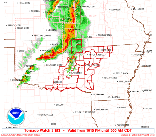
ww0193_radar.gif
 

Bevo

Member
Messages
280
Reaction score
272
Location
Dallas, TX
Today's (5/19) weather threats are as follows:


2% tornado probabilities for Montana and the stretch of far east TX, Louisiana, lower Mississippi, and Mobile area of lower Alabama.
Greatest threat for wind and hail is Montana region.
 

Brice

Member
Messages
353
Reaction score
227
Location
Lynchburg, Virginia
Don't let your guard down just because the tornado probability isn't high. We saw what could happen on a day with almost no risk and produce a mid-range EF3.
 

Bevo

Member
Messages
280
Reaction score
272
Location
Dallas, TX
Severe thunderstorm watch is now out until 10 PM MDT for Montana and a portion of Idaho.


The latest Day 1 update has added a "marginal" risk zone in the Carolinas region. Like @Brice says, good to be weather aware especially because it's May and it's 2020. Weather Twitter has been eyeing the Carolinas all day today.


Holy cannoli these temps in Texas right now!!

 
Last edited:

Bevo

Member
Messages
280
Reaction score
272
Location
Dallas, TX
Michigan...state of emergency currently...Sanford Dam has collapsed. Anyone downstream of this needs to evacuate, this is NOT a good situation! Flash flood emergency issued.


Bevo

Member
Messages
280
Reaction score
272
Location
Dallas, TX
Correction on my part—there are three dams in this area and all three have failed as of this post.
The following Twitter post information is outdated, but please refer to the map for the locations of the three dams that are now breached: Smallwood, Edenville, and Sanford.


Governor is holding a press conference right now.

 
Last edited:

warneagle

Member
Messages
4,293
Reaction score
4,740
Location
Arlington, VA
Special Affiliations
  1. SKYWARN® Volunteer
The 1986 flood was a major catastrophe for that part of the state and as it stands the flooding from this is going to obliterate that record.


Bevo

Member
Messages
280
Reaction score
272
Location
Dallas, TX


First Day 1 update for today. The enhanced region in the high plains is a wind and hail driven risk, the latter of which is a 30% chance of significant severe hail (2"+). The slight down in Texas is mostly for the threat of wind and non-sig. severe sized hail.
There are parameters in place for tornadoes stretching from Montana down to Texas, as well as the Carolinas. It isn't the largest concern between wind and hail today, but still something to watch as anything can happen if this year is anything to go by.

It appears this is the second tornado warning SC has had within the hour...so the conditions are definitely there. Should be expired now since they're EST


---DAY 1 UPDATE 17z---

Includes addition of Louisiana to marginal wind/hail risk.
Bumped up tornado probabilities to a small region E of Casper, WY to 5%.
Added significant severe hail probabilities south of Amarillo encompassing Lubbock, Midland, San Angelo, TX.
 
Last edited:

Bevo

Member
Messages
280
Reaction score
272
Location
Dallas, TX
Update on the flooding situation unfolding in Michigan...


This is what downtown Sanford looks like at the moment.


To make matters worse, there are concerns that this flooding could impact the Dow chemical complex and what that could mean from an environmental standpoint.

Stay safe, Michigan friends.
 

Weatherphreak

Member
Messages
352
Reaction score
346
Location
Huntsville
Huntsville showing severe storms on their 5 day outlook for Friday. I read the discussion and they didn't mention anything specific. My guesses would be hail and winds. It kind of caught me off guard when I saw it because I haven't really heard any rumblings of severe storms.
 

Brice

Member
Messages
353
Reaction score
227
Location
Lynchburg, Virginia
Huntsville showing severe storms on their 5 day outlook for Friday. I read the discussion and they didn't mention anything specific. My guesses would be hail and winds. It kind of caught me off guard when I saw it because I haven't really heard any rumblings of severe storms.


I've seen this event unfold before.(Hopefully and we shouldn't have a widespread tornado outbreak.) (Easter Outbreak.)
 

bjdeming

Member
Sustaining Member
Messages
1,980
Reaction score
1,758
Location
Corvallis, Oregon
More on the Edenville dam failure here, including technical discussion (unofficial and prelim only) of what may be happening in that famous video (embed and screenshots are in this AGU blog post).
 
  • Like
Reactions: KoD

Bevo

Member
Messages
280
Reaction score
272
Location
Dallas, TX
I made edits to the dates on this thread because it looks like today’s threat could get ugly. I am growing increasingly concerned based on the latest CAM runs of there being a mess of a weather event happening, particularly from Tulsa area SW into the DFW Metro.

The first Day 1 outlook already has an enhanced risk, with a 10% hatched sigtor in the area between Witchita Falls and Fort Worth all the way NE to Oklahoma.

Screen Shot 2020-05-22 at 6.56.44.png

SPC AC 220529

Day 1 Convective Outlook
NWS Storm Prediction Center Norman OK
1229 AM CDT Fri May 22 2020

Valid 221200Z - 231200Z

...THERE IS AN ENHANCED RISK OF SEVERE THUNDERSTORMS ACROSS PARTS OF
NORTHERN TEXAS AND OKLAHOMA...

...SUMMARY...
Severe storms will be likely today across parts of the southern
Plains northeastward into southeast Kansas and the Ozarks. An
enhanced threat for tornadoes, very large hail and wind damage is
expected from north Texas into southern and eastern Oklahoma.

...Southern and Central Plains/Ozarks...
An upper-level low will move east-northeastward across the central
Plains today as an associated trough moves across the southern
Plains. At the surface, a cold front will move into central Oklahoma
with a moist airmass located ahead of the front. A line of
thunderstorms is forecast to move across northern Oklahoma this
morning into the Ozarks this afternoon. South of the outflow
boundary, a moist and unstable airmass will remain in place from
north Texas into eastern Oklahoma, where moderate to strong
instability is expected to develop by early afternoon. MLCAPE values
should peak in the 3500 to 4500 J/kg range from near Wichita Falls,
Texas northeastward to south of Tulsa, Oklahoma. Convection is
forecast to initiate along this corridor during the late afternoon
with several discrete storms moving eastward across eastern and
southern Oklahoma. During the early evening, storms will also likely
develop in north and west-central Texas.

In addition to strong instability, RAP forecast soundings in parts
of the southern Plains show a favorable wind profile for supercells.
In southeast Oklahoma and north Texas, winds are forecast to veer
with height in the lowest 3 km AGL with speed shear in the
mid-levels. This combined with 700-500 mb lapse rates near 8.0 C/km
will be favorable for large hail with the stronger updrafts.
Hailstones of greater than 2 inches in diameter will be possible
with supercells co-located with the greatest instability. A tornado
threat is also expected to develop as low-level shear gradually
increases during the late afternoon and early evening. A couple
strong tornadoes may occur with the more dominant supercells, with
the greatest potential from between Wichita Falls and Fort Worth
northeastward to near McAlester, Oklahoma. An Enhanced Risk has been
added along this corridor.

The severe threat is expected to extend eastward into northern
Arkansas during the evening where large hail and wind damage will be
possible. Further north into western Missouri and eastern Kansas,
weaker instability should keep any severe threat more isolated. An
isolated severe threat is also expected in west-central Texas where
storms are expected to be very widely spaced.

...Southern Appalachians/Georgia/Carolinas...
An upper-level low will move northeastward across the Ohio Valley
today as an associated trough moves into the southern Appalachians.
Thunderstorms are expected to develop near the trough around midday
and move eastward into the Carolinas during the mid to late
afternoon. More isolated storms may also develop across parts of
northern Georgia. A moist airmass will be in place from Georgia into
the Carolinas where surface dewpoints are forecast to be in the 60s
F. As surface temperatures warm during the day, pockets of moderate
instability appear likely to develop. This combined with 0-6 km
shear of 30 to 40 kt and steep low-level lapse rates, should be
favorable for isolated severe storms. Marginally severe wind gusts
and hail would be the primary threats.

..Broyles/Lyons.. 05/22/2020
Latest couple of HRRR runs have been showing multiple rounds of discrete to semi-discrete supercells, beginning around 4 PM and continuing through at least 11 PM (cut-off of latest run). The parameters really begin to ramp up after 7 PM. Pretty scary situation in its current state due to the fact that the bulk of the activity will be happening near and around populated areas.
Second Day 1 outlook is dropping in an hour so I am curious to see if there are any adjustments to be made. I'm hoping that this will be the extent of the projected threat...gotta stay optimistic especially because I'm under the gun. :oops:
 
Last edited:
Back
Top