brianc33710
Member
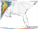
Moderate has spread more horizontally though. A sliver of SW AL now shows Mod R. Bham is now more into Slight instead of the Marginal/Slight border. The SPC gave 3 reasons that could limit the severity & scope of the severe weather that explains why they haven't gone High to this point. Moderate is bad enough though.Day One doesn't move further north, assume they're waiting for surface obs according to the discussion; little surprising that didn't expand more yet
View attachment 12735