CheeselandSkies
Member
New tornado warning for tail-end Charlie on I-10.
Follow along with the video below to see how to install our site as a web app on your home screen.
Note: This feature may not be available in some browsers.
New tornado warning for tail-end Charlie on I-10.


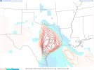
Nasty hook developing east of Seguin.
View attachment 12690
922
WFUS54 KFWD 212243
TORFWD
TXC439-212330-
/O.NEW.KFWD.TO.W.0010.220321T2243Z-220321T2330Z/
BULLETIN - EAS ACTIVATION REQUESTED
Tornado Warning
National Weather Service Fort Worth TX
543 PM CDT Mon Mar 21 2022
The National Weather Service in Fort Worth has issued a
* Tornado Warning for...
Northern Tarrant County in north central Texas...
* Until 630 PM CDT.
* At 543 PM CDT, a severe thunderstorm capable of producing a tornado
was located over Sansom Park, moving northeast at 40 mph.
HAZARD...Tornado and ping pong ball size hail.
SOURCE...Radar indicated rotation.
IMPACT...Flying debris will be dangerous to those caught without
shelter. Mobile homes will be damaged or destroyed.
Damage to roofs, windows, and vehicles will occur. Tree
damage is likely.
* This dangerous storm will be near...
Haltom City, Watauga and Richland Hills around 555 PM CDT.
North Richland Hills around 600 PM CDT.
Bedford, Hurst and Colleyville around 605 PM CDT.
Fort Worth, Euless and Southlake around 610 PM CDT.
Grapevine around 620 PM CDT.
Irving and Coppell around 625 PM CDT.
Other locations impacted by this tornadic thunderstorm include
Westover Hills and Westlake.
PRECAUTIONARY/PREPAREDNESS ACTIONS...
TAKE COVER NOW! Move to an interior room on the lowest floor of a
sturdy building. Avoid windows. If you are outdoors, in a mobile
home, or in a vehicle, move to the closest substantial shelter and
protect yourself from flying debris.
&&
LAT...LON 3298 9703 3286 9703 3272 9739 3282 9745
3299 9716
TIME...MOT...LOC 2243Z 247DEG 33KT 3280 9736
TORNADO...RADAR INDICATED
MAX HAIL SIZE...1.50 IN
$$
Dunn
247
WFUS54 KEWX 212249
TOREWX
TXC491-212315-
/O.NEW.KEWX.TO.W.0004.220321T2249Z-220321T2315Z/
BULLETIN - EAS ACTIVATION REQUESTED
Tornado Warning
National Weather Service Austin/San Antonio TX
549 PM CDT Mon Mar 21 2022
The National Weather Service in Austin San Antonio has issued a
* Tornado Warning for...
North central Williamson County in south central Texas...
* Until 615 PM CDT.
* At 549 PM CDT, a severe thunderstorm capable of producing a tornado
was located near Sun City, or near Serenada, moving northeast at 30
mph.
HAZARD...Tornado and quarter size hail.
SOURCE...Radar indicated rotation.
IMPACT...Flying debris will be dangerous to those caught without
shelter. Mobile homes will be damaged or destroyed.
Damage to roofs, windows, and vehicles will occur. Tree
damage is likely.
* Locations impacted include...
Georgetown, Serenada, Jarrell, Sun City, Theon, Schwertner and
Walburg.
PRECAUTIONARY/PREPAREDNESS ACTIONS...
TAKE COVER NOW! Move to a basement or an interior room on the lowest
floor of a sturdy building. Avoid windows. If you are outdoors, in a
mobile home, or in a vehicle, move to the closest substantial shelter
and protect yourself from flying debris.
This cluster of thunderstorms is capable of producing tornadoes and
widespread significant wind damage. Do not wait to see or hear the
tornado. For your protection move to an interior room on the lowest
floor of a building.
&&
LAT...LON 3088 9767 3087 9762 3081 9746 3067 9769
3080 9782 3088 9768
TIME...MOT...LOC 2249Z 241DEG 26KT 3076 9769
TORNADO...RADAR INDICATED
MAX HAIL SIZE...1.00 IN
$$
MO
We also have a TOR with a CC drop between Jarrell and Serenada, TX: