Archive March 18-20th, 2018 Severe Weather

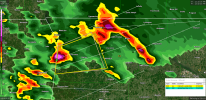
Yep. Seems that won't be as much of a factor as it seemed. That's also why I think the MOD will get expanded a bit in the afternoon update. I didn't see any SPC language about upgrading even a very limited area to high, so I think they will just refine the MOD a bit and maybe expand the ENH some to the SW.

I think their thoughts about sharp limitations to the SW aren't off base but I don't see it quite as limited at the exact point they drew. Do you think they will fill in a bit to the SW? Perhaps a hair N as well.
I want to see the special soundings first, but some of the models aren't firing off storms on the SW side of the outlook. Not sure if it is remnant capping/not enough forcing to get storms going. We'll see.
 
Is this current round of storms the main show or does that come this afternoon?
 
Sun just came out here. Temperature has risen noticeably and still incredibly humid.
 
At 12:31 PM NWS HUN has issued a Severe Thunderstorm Warning for Colbert & Lauderdale Counties until 01:00 PM
 

Attachments

  • radar.png
    radar.png
    981.6 KB · Views: 0
The app on my phone gives my temp based on the conditions at Cullman Airport (which is always cooler than here). Anyway, temp of 67, dp of 60.
 
Data so far from the BMX special sounding:

DYq0mOsXUAAlgCw.jpg
 
Why are so many schools in central AL letting out at 1:00 when Spann and others are saying the threat won't be here until 7-11pm? That doesn't make any sense at all.
 
Is there some slight rotation starting to form in the storm currently at the intersection of NW Franklin Co and SW Colbert Co?
 
FFC isn't sure the warm front's going to be getting past my location. We'll see. However, that storm over Cornelia has lost some of its strength.
 
Back
Top