- Moderator
- #1
All modes look possible across a wide area next few days.
Follow along with the video below to see how to install our site as a web app on your home screen.
Note: This feature may not be available in some browsers.
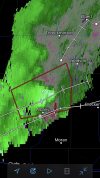
HRRR has repeatedly taken a supercell across western/northern portions of DFW metroplex this afternoon.


Mesoscale Discussion 0193
NWS Storm Prediction Center Norman OK
0249 PM CDT Wed Mar 18 2020
Areas affected...Parts of the Texas South Plains and Big Country
into the Red River Valley
Concerning...Severe potential...Watch likely
Valid 181949Z - 182145Z
Probability of Watch Issuance...80 percent
SUMMARY...The initiation of discrete thunderstorm development
appears increasingly likely by 6-7 PM CDT, and could commence as
early as 4-5 PM CDT across the Big Country near Abilene, in an
environment increasingly conducive to the formation of supercells.
The primary severe hazards initially are probably large hail and
locally strong surface gusts, but potential for tornadoes could
begin to increase by early evening.
DISCUSSION...Southwesterly mid/upper flow remains broadly
anticyclonic with rising mid-level heights across much of the
region. However, it is and should remain at least weakly difluent,
and model output continues to suggest this may transition at
mid-levels to broadly cyclonic with weak height falls, as a subtle
perturbation overspreads the region by 21-00Z. As this occurs,
there probably will be at least some tempering of increasing
lower/mid tropospheric inhibition, which is ongoing in association
with the northward advection of warmer elevated mixed-layer air.
Daytime heating of a moist boundary layer (surface dew points in the
lower to mid 60s) already appears to be contributing to mixed-layer
CAPE of 1000-2000 J/kg, as winds around 500 mb begin to increase to
40-50 kt. By the time storms initiate, the environment probably
will be conducive to supercells.
Low-level forcing to focus and support thunderstorm initiation
remains a little unclear, but weak low-level warm advection may
contribute to lift. Convection allowing guidance, particularly the
last few runs of the High Resolution Rapid Refresh, suggest
convection may initiate across the Big Country, near Abilene, as
early as 21-22Z.
Low-level hodographs are initially rather modest in size, and may
remain so until after 00-02Z, when near surface wind fields may
begin to back to south/southeasterly, while 850 mb flow begins to
strengthen to 30-40 kt, as the primary upstream short wave begins to
accelerate toward the Southwestern international border area.
However, strongest storms may still pose a risk for large hail,
locally damaging wind gusts and perhaps a brief tornado or two into
early evening.
..Kerr/Dial.. 03/18/2020
...Please see www.spc.noaa.gov for graphic product...
ATTN...WFO...FWD...OUN...SJT...LUB...MAF...
LAT...LON 34320009 34229790 33399738 32459856 30919950 30950086
31770126 34320009

Tarrant/Dallas/Denton county not included, but probably should stay alert.SEL4
URGENT - IMMEDIATE BROADCAST REQUESTED
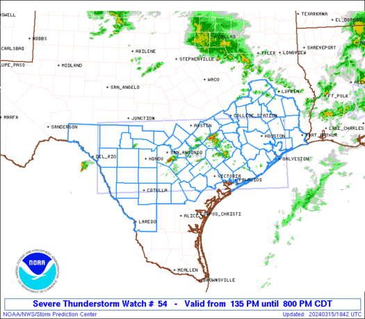
Tornado Watch Number 54
NWS Storm Prediction Center Norman OK
440 PM CDT Wed Mar 18 2020
The NWS Storm Prediction Center has issued a
* Tornado Watch for portions of
Southern Oklahoma
West Central Texas
* Effective this Wednesday afternoon from 440 PM until Midnight
CDT.
* Primary threats include...
A few tornadoes likely with a couple intense tornadoes possible
Widespread large hail and scattered very large hail events to
2.5 inches in diameter likely
Scattered damaging wind gusts to 70 mph likely
SUMMARY...Scattered intense thunderstorms are expected to develop
this afternoon and spread across the watch area through the evening.
Large hail and damaging winds will occur with the strongest cells.
Through the evening, parameters will become favorable for a few
tornadoes as well.
The tornado watch area is approximately along and 70 statute miles
north and south of a line from 30 miles south of Ardmore OK to 10
miles west southwest of Big Spring TX. For a complete depiction of
the watch see the associated watch outline update (WOUS64 KWNS
WOU4).
PRECAUTIONARY/PREPAREDNESS ACTIONS...
REMEMBER...A Tornado Watch means conditions are favorable for
tornadoes and severe thunderstorms in and close to the watch
area. Persons in these areas should be on the lookout for
threatening weather conditions and listen for later statements
and possible warnings.
&&
AVIATION...Tornadoes and a few severe thunderstorms with hail
surface and aloft to 2.5 inches. Extreme turbulence and surface wind
gusts to 60 knots. A few cumulonimbi with maximum tops to 450. Mean
storm motion vector 24035.
...Hart