bckhd2
Member
Would you prefer that they randomly guessNo, don’t tell me what I hate, I happen to love snow, I don’t like ice. What I do hate is crappy forecasts.
Follow along with the video below to see how to install our site as a web app on your home screen.
Note: This feature may not be available in some browsers.
Would you prefer that they randomly guessNo, don’t tell me what I hate, I happen to love snow, I don’t like ice. What I do hate is crappy forecasts.
No, don’t tell me what I hate, I happen to love snow, I don’t like ice. What I do hate is crappy forecasts.
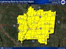
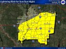
I am no expert, but I don't think anyone knows much more than a severe winter event is about to unfold and the general area that it will happen. I live in Florence, about 10 miles from the Tennessee line. I don't expect to understand exactly how it will unfold until Sunday.I’m sure that’s true, but now the governor of Alabama has declared a state of emergency for 19 northern counties. I wonder if she knows something we don’t.
I’m sure that’s true, not about being mad, which is ridiculous, but the part about the science of meteorology. But now the governor of Alabama has declared a state of emergency for 19 northern counties. I wonder if she knows something we don’t?

What has been your problem the past day or two ever since trends flipped? Model inconsistency is not a new thing and winter systems are always hard to forecast. Offices can never hit the nail on the head, you shouldn't take these forecasts as a exact guarantee. Nobody is perfect at this whole forecasting regime, technically even the professionals are still learning as we advance even further in technology and etc. The majority of these pages has been you just with all this "Forecasts are poor"No, don’t tell me what I hate, I happen to love snow, I don’t like ice. What I do hate is crappy forecasts.
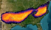
Where can I find that map?72 hr probs for freezing rain on this system. NW AL most likely to get clipped but could still be very impactful regardless. Things remain the same. Significant problems in Texas/OK/Arkansas/Mississippi/Louisiana and the Carolinas with freezing rain. Very, very potent solution here

3/4 inch of ice up here on top of probably close to a foot of snow? no thank you.View attachment 50165
Euro coming in with slightly stronger wedge, ~0.5" of freezing rain out to about I-75 corridor now
Ok, noted thx for da heads up.I feel like the National blend of models might be sending the wrong message. The Euro, GFS, and NAM are all different enough that it's screwing with the averages. If two models are showing 18 inches, but one is showing zero, that would make the average 12 inches. Obviously that's an oversimplification, but I think this is what we're seeing across a huge swath. I actually think what's really going to happen is one of the models will be right and snow/freezing rain will be much more intense than currently forecast, but in a potentially smaller area.
Basically, I think there's so much discrepancy between the models that using the NBS to make forecasts is kind of lazy and undersells the potential ceiling of this event. I'm actually convinced we'll see something closer to what the GFS is showing, but even the Euro is far more intense than the NBS.
seems fine to me. i doubt atlanta will have any issues till later in the afternoon.My youngest brother's rec baseball league is trying to cram spring tryouts in at 10:00am on Saturday. Um, ok. We'll see.