Good Evening!
It's been a while since I've talked about tropical activity in the Atlantic because basically there's been a lack of activity. Except for Tropical Storm Don spinning around the open Atlantic since last week, there's been nothing else.
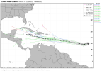
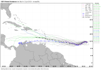
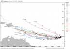
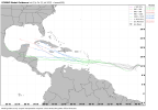
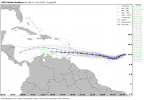
That could change within the next few days. As of this writing, the National Hurricane Center is monitoring a area of low pressure across the south-central Atlantic. They are currently giving this area a Medium chance, 50%, of becoming a tropical cyclone during the next 48 hours, and a High chance, 70%, of becoming a tropical cyclone during the next 7 days.
The three main global models, GFS, Euro, and Canadian, develop this system. However, all three differ on intensity/track. The GFS and Euro are in consensus this gets into the Caribbean by next week. The Canadian is not as impressive with this system though at the moment.
So the two main questions are: Where will it go? and How strong will it get?
Where will Invest 95L go?
As mentioned above, model consensus is for this to end up headed into the Caribbean. From there, the possibilities are endless (so to speak).
Some scenarios that are all on the table:
A. It ends up going further west and going into Central America.
B. It dissipates entirely over the Caribbean due to wind shear.
C. It remains intact and intensifies going through the Caribbean. Ends up hitting the Yucatan Peninsula and heads towards Mexico/Texas.
D. Remains intact and intensifies through the Caribbean. Ends up in the Gulf and hits the Central Gulf Coast.
or E. Same as scenario D but ends up recurving to make landfall on the west coast of Florida and/or Panhandle.
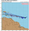
How strong will Invest 95L get?
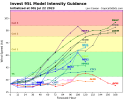
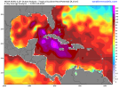
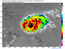
Right now, it is reasonable to assume we get at least a tropical storm or minimal low-end category 1 hurricane out of Invest 95L. Again, dependent upon wind shear and other factors, this could get pretty strong relatively fast. The waters in the Caribbean and Gulf are very warm. Conducive for a hurricane or major hurricane. In fact, if we take a look at the 12z HWRF (hurricane model) from today, we note that it's already a hurricane prior to or just after it enters the Eastern Caribbean by next Wednesday. If Invest 95L does become a hurricane in the Caribbean next week, it would be the first one to do so in July since Hurricane Emily (2005).
Speaking of warm waters, how warm are these waters currently. Glad you ask.
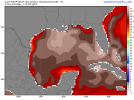
In the tropical Atlantic (west Africa to the United States), water temperatures range from 27 C (80.6 F) to 32.7 (91 F).
In the Caribbean Sea, water temperatures range from 29 C (84.2 F) to 31.5 C (89 F).
In the Gulf of Mexico, water temperatures range from 27.8 C (82 F) to 32.7 C (91 F).
That does not include Oceanic Heat Content which is the total amount of heat stored by oceans. The OHC (Oceanic Heat Content) is very high in the Caribbean south of Cuba and extends to a depth of 200 meters.
All in all, everything is there for Invest 95L to become a strong and/or major hurricane. It definitely bears watching as it could be the first big U.S. threat down the road.

 www.tropicaltidbits.com