• Welcome to TalkWeather!
    We see you lurking around TalkWeather! Take the extra step and join us today to view attachments, see less ads and maybe even join the discussion.
    CLICK TO JOIN TALKWEATHER
Logo 468x120

Severe WX Inland Severe WX From TS Cindy (6/22-6/23)

JayF

Technical Administrator
Staff member
Administrator
Moderator
Sustaining Member
Technical Admin
Messages
1,624
Reaction score
878
Location
Hartselle, al
HAM Callsign
KB4JCS
Tornado Watch Issued for Most of Central and Southern Alabama until 10 PM
 

JayF

Technical Administrator
Staff member
Administrator
Moderator
Sustaining Member
Technical Admin
Messages
1,624
Reaction score
878
Location
Hartselle, al
HAM Callsign
KB4JCS
FXUS64 KHUN 222026
AFDHUN

Area Forecast Discussion
National Weather Service Huntsville AL
326 PM CDT Thu Jun 22 2017

.NEAR TERM...(Tonight)
Issued at 326 PM CDT Thu Jun 22 2017

A couple of concerns for this afternoon and into this evening. The
first is the threat for strong to severe storms, which could impact
the eastern half of the area. We've been watching the storms moving
north out of the Birmingham area and the rainfall from this morning
has kept temperatures on the cooler side, which has prevented any
deeper updrafts from developing. However, the clearer skies over
eastern AL/western GA allowed temps to warm up into the low to mid
80s and with the strong S/SE flow pointed directly at our NE AL
counties temps have gradually warmed in the past hour or two. The
storms are starting to maintain their strength as they move into
Blount county and approach Marshall/DeKalb counties. Both wind shear
and low level helicity values are extremely favorable for tornado
development and we will be watching the storms very closely this
afternoon. With that said, there is potential for a few stronger
storms to develop over central/northern MS as the clearer skies have
allowed temps to warm into the mid to upper 80s. These may clip far
NW AL but storms will be more isolated in nature based on latest
GOES-16 visible imagery showing limited CU development.

The second concern for this afternoon and tonight is the potential
for flash flooding. Areas along and east of I-65 have received
upwards of 2-2.5 inches of rain from storms this morning. The
showers/storms moving through central AL will be moving right over
where the heavier rain fell earlier today. PWATs via the 12/18z BMX
sounding are upwards of 2.5 inches and we could easily see those
type of amounts fall in an hour in the stronger storms. Thankfully,
we've had a break in the rainfall and that has allowed for some
stabilization in the runoff and reports from those counties suggest
only ponding of water in low lying areas at this time. But the influx
of these heavier storms and potential for an additional 1-2 inches
of rain this afternoon could result in localized flash flooding.

Have decided against issuing any type of Flash Flood Watch as we
would only be concerned with the next few hours for NE AL and at
this point it's too late for one. Will mention flooding concerns in
HWO and other public products.

For the rest of the evening we can expect a gradual downward trend in
the coverage of rainfall as the drier air that is wrapping around the
eastern side of TD Cindy will keep precip limited. This additional
break in rainfall will help with any flooding that develops this
afternoon before additional rain arrives on Friday. As TD Cindy
begins to lift N/NE up through LA/AR this evening, expect winds to
increase with gusts of 20-25 mph possible tonight. The wind and
cloudy conditions will keep temps on the warmer side and values are
only forecast to drop into the low to mid 70s.

.SHORT TERM...(Friday through Saturday night)
Issued at 326 PM CDT Thu Jun 22 2017

For Friday, TD Cindy is expected to weaken to a post-tropical
cyclone as it moves further inland. The current forecast track will
take it through western TN Friday morning and then up across northern
TN/southern KY during the day. We can expect winds to be a bit higher
on Friday as we are closer to the center of the system and gusts up
to 30 mph are possible. Wouldn't be surprised to see a few isolated
reports of 35-40 mph in a few locations tomorrow.

With the storm to our north during the day we can expect partly
cloudy skies, which should allow for temps to warm into the mid 80s.
Those values combined with dewpoints remaining the low to mid 70s
should be more than enough for the development of strong to severe
storms on Friday. While the shear vectors and overall low level
helicity values won't be as strong as this afternoon, the potential
for more vigorous thunderstorm development should allow for an
increased threat for severe storms. Tornadoes, damaging wind gusts,
and flash flooding will be the hazards with storms tomorrow. We
remain in a Slight Risk via SPC and that is warranted based on the
parameters expected tomorrow.

The only good news in terms of flooding threat is that the areas that
received the heaviest rain today are expected to see lower values on
Friday and the areas that haven't seen much will get the brunt of the
rainfall tomorrow. With QPF values forecast to remain below flash
flood guidance for much of the area have held off on issuing any type
of Flash Flood Watch for tomorrow as well. Will be mainly concerned
with any type of banding/training of storms tomorrow.

The remnants of Cindy will be pushed off to the east by a cold front
that is expected to drop into the area behind the departing system.
Models have delayed the arrival of the front a bit compared to
previous guidance and don't move it completely through the area until
Saturday afternoon/evening. So, adjusted PoPs a bit to leave them in
a bit longer on Saturday. Drier air in the lower levels will be quick
to rush in during the day Saturday and likely keep any activity
limited to showers. By Saturday night all precip will be south of the
area and much cooler air spreads in with overnight lows Saturday into
Sunday will be in the low to mid 60s. This will be a welcome change
from the high humidity values we have had the past past few days.

.LONG TERM...(Sunday through Wednesday)
Issued at 326 PM CDT Thu Jun 22 2017

Dry conditions will persist through the long term period, as surface
high pressure slides southward into the region. Temperatures will be
on the "cool" side for late June, given a broad upper level trough
that will remain anchored over the eastern CONUS. High temperatures
will generally remain in the lower 80s on Sunday through Tuesday,
with a gradual warming trend beginning Wednesday. Under good
radiational cooling conditions, overnight lows will cool into the
upper 50s each night.

&&

.AVIATION...(For the 18Z TAFS through 18Z Friday afternoon)
Issued at 1220 PM CDT Thu Jun 22 2017

The rain from this morning has shifted off to the east but another
band of rain is moving up from the north. Based on the movement of
this secondary band believe it will stay to the east of the KMSL
terminal. Could arrive between 19-20z into the KHSV terminal with
cigs/vis alternating between MVFR/IFR conditions. There is drier air
to the east of TD Cindy that is over central MS and this will move
over the TN Valley later tonight pushing the rain off to the east.
Expect southerly winds to increase through the afternoon and pick
even more during the day Friday as the center of TD Cindy passes just
to the north.

Amendments might be needed to handle any changes in the movement of
the rain band this afternoon/evening.
 

JayF

Technical Administrator
Staff member
Administrator
Moderator
Sustaining Member
Technical Admin
Messages
1,624
Reaction score
878
Location
Hartselle, al
HAM Callsign
KB4JCS
000
WFUS54 KBMX 222038
TORBMX
ALC123-222130-
/O.NEW.KBMX.TO.W.0042.170622T2038Z-170622T2130Z/

BULLETIN - EAS ACTIVATION REQUESTED
Tornado Warning
National Weather Service Birmingham AL
338 PM CDT THU JUN 22 2017

The National Weather Service in Birmingham has issued a

* Tornado Warning for...
Northeastern Tallapoosa County in east central Alabama...

* Until 430 PM CDT

* At 338 PM CDT, a severe thunderstorm capable of producing a tornado
was located over Jacksons' Gap, or over Dadeville, moving northeast
at 40 mph.

HAZARD...Tornado.

SOURCE...Radar indicated rotation.

IMPACT...Flying debris will be dangerous to those caught without
shelter. Mobile homes will be damaged or destroyed.
Damage to roofs, windows, and vehicles will occur. Tree
damage is likely.

* Locations impacted include...
Dadeville, Jacksons' Gap, New Site, Jacksons Gap, Daviston, Dare
Park, Eagle Creek, Horseshoe Bend and Horseshoe Bend National
Military Park.

PRECAUTIONARY/PREPAREDNESS ACTIONS...

TAKE COVER NOW! Move to a basement or an interior room on the lowest
floor of a sturdy building. Avoid windows. If you are outdoors, in a
mobile home, or in a vehicle, move to the closest substantial shelter
and protect yourself from flying debris.

&&

LAT...LON 3280 8583 3282 8587 3311 8572 3311 8562
3309 8559 3296 8559
TIME...MOT...LOC 2038Z 217DEG 35KT 3285 8580

TORNADO...RADAR INDICATED
HAIL...<.75IN
 

JayF

Technical Administrator
Staff member
Administrator
Moderator
Sustaining Member
Technical Admin
Messages
1,624
Reaction score
878
Location
Hartselle, al
HAM Callsign
KB4JCS
TROPICAL DEPRESSION CINDY ADVISORY NUMBER 13
NWS WEATHER PREDICTION CENTER COLLEGE PARK MD AL032017
500 PM EDT THU JUN 22 2017

...TROPICAL DEPRESSION CINDY CONTINUES TO PRODUCE HEAVY RAINFALL
FROM THE LOWER MISSISSIPPI VALLEY THROUGH THE SOUTHEAST AND INTO
THE OHIO VALLEY...

SUMMARY OF 500 PM EDT...2100 UTC...INFORMATION
-----------------------------------------------
LOCATION...31.9N 93.7W
ABOUT 46 MILES...74 KM...S OF SHREVEPORT LOUISIANA.
ABOUT 35 MILES...56 KM...WNW OF NATTCHITOCHES LOUISIANA.
MAXIMUM SUSTAINED WINDS...20 MPH...30 KM/H
PRESENT MOVEMENT...NNE OR 25 DEGREES AT 10 MPH...16 KM/H
MINIMUM CENTRAL PRESSURE...999 MB...29.50 INCHES


WATCHES AND WARNINGS
--------------------
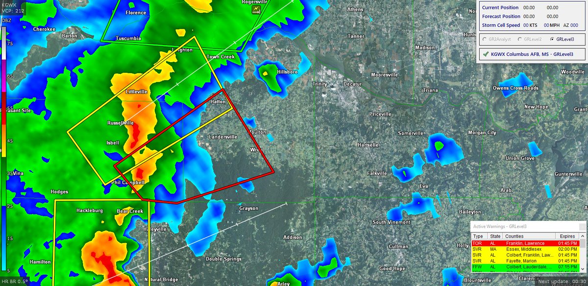
FLASH FLOOD WARNINGS ARE IN EFFECT FOR A SMALL PORTION OF CENTRAL
ALABAMA.
FLASH FLOOD WATCHES...FLOOD WARNINGS...AND FLOOD ADVISORIES ARE IN
EFFECT FROM EAST TEXAS INTO THE LOWER MISSISSIPPI
VALLEY...NORTHWARD INTO THE TENNESSEE/OHIO VALLEYS...AND THE
CENTRAL APPALACHIANS.
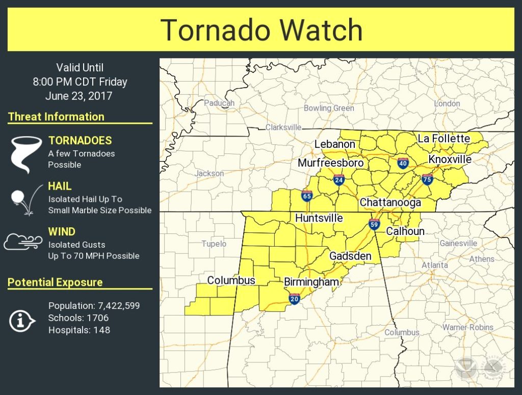
A TORNADO WATCH IS IN EFFECT FOR THE EASTERN PORTIONS OF THE LOWER
MISSISSIPPI VALLEY AND MOST OF MISSISSIPPI AND ALABAMA.

FOR INFORMATION SPECIFIC TO YOUR AREA...INCLUDING POSSIBLE WATCHES
AND WARNINGS...PLEASE MONITOR PRODUCTS ISSUED BY YOUR LOCAL
NATIONAL WEATHER SERVICE OFFICE AT WWW.WEATHER.GOV.


DISCUSSION AND 48-HOUR OUTLOOK
------------------------------
AT 500 PM EDT...2100 UTC...THE CENTER OF CINDY WAS LOCATED NEAR
LATITUDE 31.9 NORTH...AND LONGITUDE 93.7 WEST. TROPICAL DEPRESSION
CINDY IS CURRENTLY ASSOCIATED WITH SCATTERED SHOWERS AND
THUNDERSTORMS ROTATING AROUND ITS CENTER THROUGH EAST TEXAS AND
THE LOWER MISSISSIPPI VALLEY. RADAR AND SURFACE OBSERVATIONS SHOW
A CLUSTER OF THUNDERSTORMS IN EXTREME EASTERN TEXAS...WITH
SCATTERED SHOWERS AND THUNDERSTORMS THROUGHOUT LOUISIANA...AND
THUNDERSTORMS MOVING NORTHWARD ACROSS ARKANSAS. THERE IS ALSO A
SECONDARY PLUME OF MOISTURE MOVING ACROSS EASTERN MISSISSIPPI AND
ALABAMA THAT IS PRODUCING THUNDERSTORMS ACROSS BOTH OF THESE
STATES IN ADDITION TO WESTERN GEORGIA. A SWATH OF LIGHT TO
MODERATE RAIN IS ALSO MOVING NORTHWARD THROUGH THE TENNESSEE AND
OHIO VALLEYS IN ADDITION TO THE CAROLINAS. TROPICAL DEPRESSION
CINDY WILL WEAKEN AS IT KEEPS A NORTHWARD TRACK THROUGH TONIGHT
AND WILL BEGIN TURNING NORTHEASTWARD BY FRIDAY MORNING AS IT
WEAKENS TO A POST-TROPICAL CYCLONE...ENTERING INTO WESTERN
TENNESSEE AND MOVE CENTRAL KENTUCKY BY FRIDAY EVENING. THE
PRIMARY THREAT WITH THIS STORM IS MODERATE TO HEAVY RAIN
THROUGHOUT THE LOWER MISSISSIPPI VALLEY...SOUTHEAST...AND EASTWARD
INTO THE CENTRAL APPALACHIANS.

MAXIMUM SUSTAINED WINDS ARE NEAR 20 MPH...30 KM/H...WITH HIGHER
GUSTS.

MINIMUM CENTRAL PRESSURE IS 999 MB...29.50 INCHES.


HAZARDS
-------
RAINFALL...TROPICAL DEPRESSION CINDY IS EXPECTED TO PRODUCE 2 TO 4
INCHES...WITH LOCALLY HIGHER AMOUNTS...FROM NORTHERN LOUISIANA
INTO WESTERN TENNESSEE...AND INTO KENTUCKY AND THE CENTRAL
APPALACHIANS. THESE RAINS WILL CONTINUE TO ENHANCE FLASH FLOODING
ACROSS THESE REGIONS...SOME OF WHICH COULD BE LIFE THREATENING
ESPECIALLY ACROSS LOUISIANA AND SOUTHEAST ARKANSAS.


RAINFALL TOTALS
---------------
SELECTED STORM TOTAL RAINFALL IN INCHES THROUGH 2 PM EDT

...ALABAMA...
PRATTVILLE 1 N 6.80
MOBILE/BATES FIELD 6.65
EVERGREEN 5.97
GREENVILLE 2 WSW 4.40
EXCEL 3 ESE 4.30
REPTON 6 S 4.00
URIAH 8 W 3.90
POLLARD 2 N 3.70
DANNELLY FIELD 1 W 3.70
MONTGOMERY COUNTRY 2 E 3.60
MONTGOMERY/DANNELLY 3.53
BAY MINETTE 11 N 3.50
TUSCALOOSA MUNI ARPT 3.41

...FLORIDA...
NAVARRE 8.30
PENSACOLA RGNL ARPT 8.28
JOHNSONS BEACH 3 NNE 8.00
MILTON/WHITING FIELD NAS 6.36
PENSACOLA 4 W 6.10
APALACHICOLA MUNI ARPT 5.34
PANAMA CITY BEACH 0.3 SW 5.20
VALPARAISO/EGLIN AFB 5.16
CRESTVIEW/BOB SIKES 5.08
DESTIN AIRPORT 4.95
HURLBURT FIELD AWS 4.66
TYNDALL AFB/PANAMA CITY 4.49
GONZALEZ 3 NNW 3.50
NICEVILLE 2 SE 3.30
ELGIN AFB 6 NE 3.30

...LOUISIANA...
SULPHUR 2 E 4.30
BOOTHVILLE 4.21
WESTLAKE 1 WNW 4.20
HOUMA 4 SE 4.10
NEW ORLEANS/MOISANT 4.08
TIMBERLANE 3.80
CHAUVIN 3 NNE 3.80
BELLE CHASSE 2 NNE 3.50
SLIDELL 3.37
LAKE CHARLES 5 SSE 3.00
DENHAM SPRINGS 4 NE 2.60
BATON ROUGE 4 E 2.40
RAGLEY 5 SE 2.10
PONCHATOULA 1 SW 1.70

...MISSISSIPPI...
OCEAN SPRINGS 2 E 12.30
KEESLER AFB/BILOXI 8.71
GULFPORT-BILOXI 8.58
WIGGINS 8.50
PASCAGOULA 5.38
WAYNESBORO 5 WNW 4.00
HATTIESBURG/CHAIN MUNI ARPT 3.80
PURVIS 14 ESE 3.40
DIAMONDHEAD 1 E 3.40
BILOXI 13 NNW 3.40
ACKERMAN 5 W 3.40
COLUMBIA 3 NNE 3.30
PHILADELPHIA 5 SW 3.20

...TENNESSEE...
PULASKI 8 ENE 1.20
FAYETTEVILLE 1 SSW 1.10
CORNERSVILLE 11 SSE 1.00

...TEXAS...
KIRBYVILLE 2 SE 2.90
GALVESTON 6 NE 2.90
LEAGUE CITY 3 NE 2.50
BROADDUS 15 SE 2.50
KEMAH 0.2 WNW 2.30
BEAUMONT 5 S 2.30
LUMBERTON 1 WNW 2.20
BUNA 1 N 2.10
NASSAU BAY 2 NNW 1.90
BAFLIFF 1 SSE 1.90


NEXT ADVISORY
-------------
NEXT ADVISORY ISSUED AT 1100 PM EDT. PLEASE REFER TO YOUR LOCAL
NATIONAL WEATHER SERVICE OFFICE FOR FURTHER INFORMATION ON THIS
STORM.

FORECASTER REINHART

FORECAST POSITIONS
------------------
INITIAL 22/2100Z 31.9N 93.7W
12HR VT 23/0600Z 33.8N 92.1W...POST-TROPICAL/REMNANT LOW
24HR VT 23/1800Z 35.9N 89.6W...POST-TROPICAL/REMNANT LOW
36HR VT 24/0600Z 38.3N 81.1W...POST-TROPICAL/REMNANT LOW
48HR VT 24/1800Z 40.5N 73.4W...POST-TROPICAL/REMNANT LOW
$$
 

South AL Wx

Member
Meteorologist
Messages
309
Reaction score
311
Location
Wetumpka, AL
Special Affiliations
  1. SKYWARN® Volunteer
According to ABC 33/40, the Fairfield tornado has been given a preliminary rating of EF-2 with 120 mph winds.

NWS report:
*** 3 INJ ***
STRUCTURAL DAMAGE REPORTED AT A LIQUOR STORE
NEAR WESTERN HILLS MALL IN FAIRFIELD.
POSSIBLE ENTRAPMENT AND 3 INJURIES REPORTED.
STORM SURVEY FINDS DAMAGE CONSISTENT WITH
ESTIMATED 120 MPH WINDS, EF-2 NEAR THE
INTERSECTION OF DR. MARTIN LUTHER KING
BOULEVARD AND WEIBEL DRIVE.
 
Last edited:

Taylor Campbell

Moderator
Moderator
PerryW Project Supporter
Messages
2,102
Reaction score
2,189
Location
Wedowee, AL
Special Affiliations
  1. SKYWARN® Volunteer
Several rotating storms in North Georgia right now.
 

bingcrosbyb

Member
Messages
58
Reaction score
21
Location
Cahaba Heights (Birmingham)
EF2 close to end of June is impressive. What is more impressive is the amount of video that was taken from downtown Birmingham businesses in the upper floors of the lowering. It could certainly have been worse given the damage to the local businesses in Fairfield. Never sleep on land falling tropical systems.
 

Daryl

Member
Messages
316
Reaction score
99
Location
Boaz,AL
Area Forecast Discussion National Weather Service Huntsville AL 947 AM CDT Fri Jun 23 2017

.NEAR TERM...(Rest of Today) Issued at 946 AM CDT Fri Jun 23 2017 It will be an active day weather wise across the TN Valley as the remnants of TD Cindy begin to shift E/NE across northern TN. This morning we were dealing with a weak convergence axis that spawned some light to moderate showers out ahead of the main band of precip that remains off to the west. We are starting to see some breaks in the cloud cover and as a result temps are warming into the lower 80s across the western half of the area. The threats for today will be tornadoes and flooding. The warmer temps and slightly steeper lapse rates compared to yesterday should allow for instability to range from 300-700 J/kg. In addition to this, the strong S/SW winds out ahead of the system has resulted in a bulls-eye of 30-40kts of effective shear and helicity values upwards of 400 m2/s2. These values are very favorable rotation and any stronger storms that do form will be able to tap into these values and a few tornadoes are certainly possible later this morning into the early afternoon hours. There is a chance that a Tornado Watch might be needed for our area later today but we will continue to monitor the conditions and coordinate with SPC on that.
 

HazardousWx

Member
Messages
91
Reaction score
87
Location
Huntsville, AL
HAM Callsign
W4SSW
Special Affiliations
  1. SKYWARN® Volunteer
Severe Weather Statement
National Weather Service Memphis TN
1041 AM CDT FRI JUN 23 2017

MSC057-117-231615-
/O.CON.KMEG.TO.W.0031.000000T0000Z-170623T1615Z/
Itawamba MS-Prentiss MS-
1041 AM CDT FRI JUN 23 2017

...A TORNADO WARNING REMAINS IN EFFECT UNTIL 1115 AM CDT FOR
NORTHWESTERN ITAWAMBA AND SOUTH CENTRAL PRENTISS COUNTIES...

At 1041 AM CDT, a severe thunderstorm producing a tornado was located
near Mantachie, or 10 miles southeast of Baldwyn, moving northeast at
40 mph.

HAZARD...Tornado.

SOURCE...Radar indicated rotation.

IMPACT...Flying debris will be dangerous to those caught without
shelter. Mobile homes will be damaged or destroyed. Damage
to roofs, windows, and vehicles will occur. Tree damage is
likely.

This dangerous storm will be near...
Sandy Springs around 1050 AM CDT.

Other locations impacted by this tornadic thunderstorm include
Marietta and Kirkville.
 

HazardousWx

Member
Messages
91
Reaction score
87
Location
Huntsville, AL
HAM Callsign
W4SSW
Special Affiliations
  1. SKYWARN® Volunteer
Severe Weather Statement
National Weather Service Memphis TN
1054 AM CDT FRI JUN 23 2017

MSC057-117-231604-
/O.CAN.KMEG.TO.W.0031.000000T0000Z-170623T1615Z/
Itawamba MS-Prentiss MS-
1054 AM CDT FRI JUN 23 2017

...THE TORNADO WARNING FOR NORTHWESTERN ITAWAMBA AND SOUTH CENTRAL
PRENTISS COUNTIES IS CANCELLED...

The storm which prompted the warning has weakened below severe
limits, and has exited the warned area. Therefore, the warning has
been cancelled.
 

Daryl

Member
Messages
316
Reaction score
99
Location
Boaz,AL
mcd1130.gif


Mesoscale Discussion 1130
NWS Storm Prediction Center Norman OK
1054 AM CDT Fri Jun 23 2017

Areas affected...Middle TN...Northeast MS...Central/northern AL

Concerning...Severe potential...Watch likely

Valid 231554Z - 231730Z

Probability of Watch Issuance...80 percent

SUMMARY...A gradual increase in the severe threat is expected late
this morning into the afternoon. A few tornadoes and isolated
damaging wind gusts will be the primary threats. Watch issuance is
likely late this morning or early this afternoon.

DISCUSSION...Convection has been increasing in intensity this
morning, along the leading edge of the broader precipitation shield
associated with TC Cindy. The environment ahead this convection is
characterized by very moist/tropical profiles, with poor lapse rates
but favorable wind profiles for supercells and other organized storm
structures. As continued heating and modest destabilization occurs
downstream, the severe threat is expected to increase. Recent CAM
guidance is suggestive of a mixed-mode threat, with some tornado
threat resulting from mini-supercell development, while a threat of
damaging wind gusts will increase with larger-scale convective line
segments.

In a relative sense, the tornado threat will likely be greatest
across the northern portion of the MCD area, where backed low-level
flow will increase low-level shear/SRH, while the wind threat may be
maximized further south, where low-level flow remains strong but
vertical profiles would tend to favor line segments. One or more
watches are likely late this morning or early this afternoon to
cover these threats.
 

NorthBamaWX

Member
Messages
197
Reaction score
55
Location
Athens Alabama
The National Weather Service in Memphis has issued a

* Tornado Warning for...
Northeastern Itawamba County in northeastern Mississippi...

* Until noon CDT

* At 1138 AM CDT, a severe thunderstorm producing a tornado was
located near Fairview, or 9 miles southwest of Red Bay, moving
northeast at 45 mph.

HAZARD...Tornado.

SOURCE...Radar indicated rotation.

IMPACT...Flying debris will be dangerous to those caught without
shelter. Mobile homes will be damaged or destroyed.
Damage to roofs, windows, and vehicles will occur. Tree
damage is likely.

* This tornadic thunderstorm will remain over mainly rural areas of
northeastern Itawamba County, including the following locations:
Eastman and Bounds Crossroads.

PRECAUTIONARY/PREPAREDNESS ACTIONS...

TAKE COVER NOW! Move to a storm shelter or an interior room on the
lowest floor of a sturdy building. Avoid windows. If you are
outdoors, in a mobile home, or in a vehicle, move to the closest
substantial shelter and protect yourself from flying debris.
 

NorthBamaWX

Member
Messages
197
Reaction score
55
Location
Athens Alabama
BULLETIN - IMMEDIATE BROADCAST REQUESTED
Severe Thunderstorm Warning
National Weather Service Huntsville AL
1154 AM CDT FRI JUN 23 2017

The National Weather Service in Huntsville Alabama has issued a

* Severe Thunderstorm Warning for...
Southwestern Colbert County in northwestern Alabama...
Northwestern Franklin County in northwestern Alabama...

* Until 1230 PM CDT

* At 1154 AM CDT, a severe thunderstorm was located 7 miles northeast
of Red Bay, moving northeast at 50 mph.

HAZARD...60 mph wind gusts.

SOURCE...Radar indicated.

IMPACT...Expect damage to roofs, siding, and trees.

* Locations impacted include...
Vina, Posey Loop, Cedar Creek Reservoir, New Bethel, Srygley
Church, Halltown, Red Rock, Pleasant Site, Dempsey and Crooked Oak.

PRECAUTIONARY/PREPAREDNESS ACTIONS...

For your protection move to an interior room on the lowest floor of a
building.
 

Daryl

Member
Messages
316
Reaction score
99
Location
Boaz,AL
ww0365_radar_big.gif


URGENT - IMMEDIATE BROADCAST REQUESTED
Tornado Watch Number 365
NWS Storm Prediction Center Norman OK
1215 PM CDT Fri Jun 23 2017

The NWS Storm Prediction Center has issued a

* Tornado Watch for portions of
Western and Northern Alabama
Northwest Georgia
Eastern Mississippi
Middle and Eastern Tennessee

* Effective this Friday afternoon and evening from 1215 PM until
800 PM CDT.

* Primary threats include...
A few tornadoes possible
Isolated damaging wind gusts to 70 mph possible

SUMMARY...Preceding the east/northeastward-moving remnants of Cindy,
a very air mass and strong low/mid-level winds will support both
organized bowing structures and some line-preceding or embedded
supercells capable of a few tornadoes and locally damaging winds
this afternoon into early evening.

The tornado watch area is approximately along and 80 statute miles
east and west of a line from 45 miles north northeast of Crossville
TN to 20 miles south southwest of Tuscaloosa AL. For a complete
depiction of the watch see the associated watch outline update
 

JayF

Technical Administrator
Staff member
Administrator
Moderator
Sustaining Member
Technical Admin
Messages
1,624
Reaction score
878
Location
Hartselle, al
HAM Callsign
KB4JCS
Wait what! NWS in Birmingham is now issuing Thunderstorms. From their twitter feed. LOL

BMX issues A LINE OF STRONG THUNDERSTORMS WILL AFFECT PICKENS, SOUTHWESTERN FAYETTE AND SOUTHE till 2:00 PM CDT
 

NorthBamaWX

Member
Messages
197
Reaction score
55
Location
Athens Alabama
BULLETIN - IMMEDIATE BROADCAST REQUESTED
Severe Thunderstorm Warning
National Weather Service Huntsville AL
113 PM CDT FRI JUN 23 2017

The National Weather Service in Huntsville Alabama has issued a

* Severe Thunderstorm Warning for...
Southeastern Colbert County in northwestern Alabama...
Eastern Franklin County in northwestern Alabama...
West central Lawrence County in northwestern Alabama...

* Until 145 PM CDT

* At 113 PM CDT, a severe thunderstorm was located near Russellville,
moving northeast at 50 mph.

HAZARD...60 mph wind gusts.

SOURCE...Radar indicated.

IMPACT...Expect damage to roofs, siding, and trees.

* Locations impacted include...
Russellville, Littleville, Leighton, Belgreen, La Grange,
Tharptown, Ne Smith, Rockwood, Hatton and Pleasant Ridge.

PRECAUTIONARY/PREPAREDNESS ACTIONS...

For your protection move to an interior room on the lowest floor of a
building.
DDBnvkNUAAUJWSv.jpg
 

NorthBamaWX

Member
Messages
197
Reaction score
55
Location
Athens Alabama
BULLETIN - EAS ACTIVATION REQUESTED
Tornado Warning
National Weather Service Huntsville AL
121 PM CDT FRI JUN 23 2017

The National Weather Service in Huntsville Alabama has issued a

* Tornado Warning for...
Southeastern Franklin County in northwestern Alabama...
Southwestern Lawrence County in northwestern Alabama...

* Until 145 PM CDT

* At 121 PM CDT, a severe thunderstorm capable of producing a tornado
was located near Phil Campbell, or 9 miles north of Haleyville,
moving northeast at 50 mph.

HAZARD...Tornado.

SOURCE...Radar indicated rotation.

IMPACT...Flying debris will be dangerous to those caught without
shelter. Mobile homes will be damaged or destroyed.
Damage to roofs, windows, and vehicles will occur. Tree
damage is likely.

* This tornadic thunderstorm will remain over mainly rural areas of
southeastern Franklin and southwestern Lawrence Counties, including
the following locations: Mt Hope, Wren, Landersville, Newburg and
Hatton.

PRECAUTIONARY/PREPAREDNESS ACTIONS...

TAKE COVER NOW! Move to a basement or an interior room on the lowest
floor of a sturdy building. Avoid windows. If you are outdoors, in a
mobile home, or in a vehicle, move to the closest substantial shelter
and protect yourself from flying debris.
DDBpWt6UMAIyPKk.jpg
 
Back
Top