
Right, nobody think we've dodged any bullets yet, this was forecast and it's still going to be a historic hit I fear.But worth remembering that Katrina was C3 at landfall and still did unimaginable damage.
Navigation
Install the app
How to install the app on iOS
Follow along with the video below to see how to install our site as a web app on your home screen.
Note: This feature may not be available in some browsers.
More options
-
Welcome to TalkWeather! We see you lurking around TalkWeather! Take the extra step and join us today to view attachments, see less ads and maybe even join the discussion. CLICK TO JOIN TALKWEATHER
You are using an out of date browser. It may not display this or other websites correctly.
You should upgrade or use an alternative browser.
You should upgrade or use an alternative browser.
Hurricane Hurricane Milton
- Thread starter KevinH
- Start date
tornado examiner
Member
Ike in 2008 was a category 2 at landfall and it altered the shores of Texas like a megaflood would.
tornado examiner
Member

This is something a category 2 can do.
Do not underestimate Milton what so ever,
TH2002
Member
- Messages
- 4,973
- Reaction score
- 11,113
- Location
- California, United States
- Special Affiliations
- SKYWARN® Volunteer
OHWX97
Member
The one northwest of Okeechobee looks really bad too.Two tornadoes OTG in central Florida currently. In particular, deep TDS near Placid Lakes.

wx_guy
Member
- Messages
- 1,237
- Reaction score
- 4,443
- Location
- United States
- HAM Callsign
- KO4ZGH
- Special Affiliations
- SKYWARN® Volunteer
- ARRL Member
Dang, this tornado outbreak rivals the worst I've ever seen in a tropical cyclone.
View attachment 30750
This is something a category 2 can do.
Do not underestimate Milton what so ever,
Ike was a bit of a special case however given how massive it was, its hurricane force winds extended up to 180 miles from the center, as opposed to 35 miles currently for Milton.
Ike is one of many examples to show the pitfalls of using only the saffir-Simpson scale to relay hurricane strength, but it might be the biggest example.

OHWX97
Member
Damaging tornado ongoing northeast of Okeechobee.

IKE should be the new scale - Integrated Kinetic Energy.Ike was a bit of a special case however given how massive it was, its hurricane force winds extended up to 180 miles from the center, as opposed to 35 miles currently for Milton.
Ike is one of many examples to show the pitfalls of using only the saffir-Simpson scale to relay hurricane strength, but it might be the biggest example.
wx_guy
Member
- Messages
- 1,237
- Reaction score
- 4,443
- Location
- United States
- HAM Callsign
- KO4ZGH
- Special Affiliations
- SKYWARN® Volunteer
- ARRL Member
What's this? I'm intriguedIKE should be the new scale - Integrated Kinetic Energy.
brianc33710
Member
Had Milton not attempted another EWRC right before hitting the shear, he would've held together better. Here's Mike's Weather Page on FB. Almost every weather model shows landfall north of the NHC track, which won't update till 5.

Added a link in my post. Katrina spawned a lot of discussion on the need for a new system, but with the following quiet years, I expect the urgency of something better wasn't felt.What's this? I'm intrigued
notsoencrypted
Member
At this point, I have RadarScope open just to see how many different tornado warnings there are. Wow.
Just nuts.At this point, I have RadarScope open just to see how many different tornado warnings there are. Wow.

OHWX97
Member
Damaging tornadoes still ongoing with both of the cells moving northwest, away from Okeechobee.

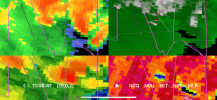
Yep, two rather nasty-looking TDS and TVS signatures in the Fort Drum area. Curious if they will adjust the warning text to indicate both or issue separate warnings.Damaging tornadoes ongoing with both of the cells moving north away from Okeechobee.
View attachment 30758

DUUUVAAAAALLLLLLLLLLLL
Member
They are gonna merge and make tornado babies.Damaging tornadoes still ongoing with both of the cells moving northwest, away from Okeechobee.
View attachment 30758