tornado examiner
Member
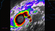
Could it remain as a category 5 through the ewrc?Wind field is gradually expanding already. The EWRC will only accelerate that.
This will not be a "small storm" at landfall.
Follow along with the video below to see how to install our site as a web app on your home screen.
Note: This feature may not be available in some browsers.
Could it remain as a category 5 through the ewrc?Wind field is gradually expanding already. The EWRC will only accelerate that.
This will not be a "small storm" at landfall.
The HAFS-B model implies it will then tighten the larger eyewall down to 884mb as it passes over the loop current north of the Yucatan channel. It will soon thereafter ingest a big slug of dry air that it wraps around itself from the north. That's the basics of what's expected. We've all been talking here at various times over the last couple days about whether HAFS was overdoing it, but so far it's been the only one that came close to what Milton has actually done in terms of strength.I wonder what it's gonna do after the EWRC completes.

Area Forecast Discussion
National Weather Service Tampa Bay Ruskin FL
158 PM EDT Mon Oct 7 2024
...New SHORT TERM, LONG TERM, AVIATION, MARINE, FIRE WEATHER...
.SHORT TERM...
(This evening through Thursday)
Issued at 156 PM EDT Mon Oct 7
2024
Major Hurricane Milton is now an extremely strong Cat 5 hurricane
with winds up to 175 mph. Milton will grow in size as it heads
towards the West Coast of Florida as a disastrous hurricane. Milton
is expected to weaken slightly but will still be a major Cat 3
hurricane at landfall with destructive damage expected on Wednesday.
Storm Surge along and south of the track will be life threatening
and catastrophic. If you are asked to evacuate you need to do so.
This storm surge will be life threatening. The high winds will also
cause widespread and major damage as the eyewall tracks through the
state. If you are outside of the storm surge area and decide to stay
you need to have supplies to last for a week or more without power
or water.
Bottom line: If Milton stays on its course this will be the most
powerful hurricane to hit Tampa Bay in over 100 years. No one in the
area has ever experience a hurricane this strong before.

Bold statement.The fact that the EWRC might make Milton stronger is extremely concerning. I think it will hit Florida at Category 5 intensity.