• Welcome to TalkWeather!
    We see you lurking around TalkWeather! Take the extra step and join us today to view attachments, see less ads and maybe even join the discussion.
    CLICK TO JOIN TALKWEATHER

Harvey inland severe threat (August 31-September 1)

Snowfan

Member
Messages
8
Reaction score
0
Location
Not telling
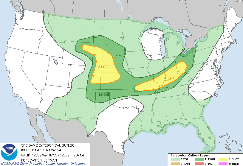
day2otlk_1730.gif

Harvey could bring isolated tornados.
 

Snowfan

Member
Messages
8
Reaction score
0
Location
Not telling
634
FXUS62 KFFC 310836
AFDFFC

Area Forecast Discussion
National Weather Service Peachtree City GA
436 AM EDT Thu Aug 31 2017


.SHORT TERM /Today through Friday/...

Wet short term forecast in store as the remnants of Harvey impact
the area as it lifts northward across the Tennessee Valley. Have
generally kept likely pops in for today with widespread showers and
embedded thunderstorms are expected. Precip will likely be in waves,
with breaks in activity allowing for some potential clearing in
cloud cover and better insolation. The environment will continue to
destabilize today as a warm front lifts northward and wedge over
northeast GA erodes. Expect convection to ramp up with solar heating
today. Tornado threat is non-zero across the CWA, but especially
over NW GA as storms interact with the warm front boundary. Enhanced
low level helicity and most instability will be over NW GA, and SPC
has this area in a Slight Risk for severe storms today. The
remainder of the CWA is in a Marginal Risk for severe storms.

Best precip coverage will transition across far north Georgia this
evening and overnight into Friday, and have followed suit with the
pops before the best moisture/dynamics exit late Friday. SPC has
north GA in a Marginal Risk through Friday.


Rainfall amounts into the weekend are lower than previous forecast
packages, and although there is still a possibility of localized
flash flooding, the potential is lower than thought earlier. See the
hydrology section below.

Temperatures through the short term remain below normal,
particularly across far north GA due to the placement of the warm
front, the precip coverage and insolation.

&&

.Hydrology...
Latest forecast rainfall amounts through Saturday are generally 1 to
1.5 inches, with the highest amounts over northeast GA. As waves of
precipitation impact the area, storms could produce periods of heavy
rain. The state should be able to handle these amounts without any
issue. However, in areas where these storms train, or move over the
same location, localized flash flooding is possible.
 

JayF

Technical Administrator
Staff member
Administrator
Moderator
Sustaining Member
Technical Admin
Messages
1,624
Reaction score
878
Location
Hartselle, al
HAM Callsign
KB4JCS
James Paul Dice is reporting a Tornado Warning in Kemper County Mississippi. JPD_TW_DIkdMsyXUAAn2RP.jpg
 

Daryl

Member
Messages
316
Reaction score
99
Location
Boaz,AL
mcd1605.gif


Mesoscale Discussion 1605
NWS Storm Prediction Center Norman OK
1031 AM CDT Thu Aug 31 2017

Areas affected...Parts of eastern Mississippi into western Alabama

Concerning...Severe potential...Watch possible

Valid 311531Z - 311730Z

Probability of Watch Issuance...60 percent

SUMMARY...Some increase in the risk for generally isolated and
relatively short-lived tornadoes may occur through midday and early
afternoon. It is not yet certain that a watch will be needed, but
trends are being monitored for this possibility.

DISCUSSION...East of the remnant circulation center of Harvey,
tropical boundary layer moisture (mid 70s+ F surface dew points)
remains present in a narrow corridor roughly centered near the
Mississippi/Alabama state border area. Breaks in cloud cover across
this region have allowed for some insolation and destabilization, as
a broken band of convection pivots across the region. Coinciding
with a broad belt of 30-50 kt southerly 850 mb flow, which is
contributing to sizable low-level hodographs where near surface flow
remains southeasterly (mainly ahead of the broken band of
convection), at least some risk for brief tornadoes remains evident.
However, the extent of this threat remains unclear, and will
probably hinge on whether rain cooled air now present across much of
central and southern Alabama can modify appreciably. Currently this
seems unlikely, but a couple of corridors of substantive further
boundary layer destabilization seem at least possible. One of these
may extend north and east of Biloxi MS into southwestern Alabama
(near/north of Mobile). The other may develop near Tuscaloosa
northwestward into areas near/east of Tupelo and Columbus MS.
 

JayF

Technical Administrator
Staff member
Administrator
Moderator
Sustaining Member
Technical Admin
Messages
1,624
Reaction score
878
Location
Hartselle, al
HAM Callsign
KB4JCS
Tornado Watch for North Alabama to include Colbert, Cullman, Franklin, Lauderdale, Lawrence, LImestone, and Morgan Counties until 8 PM.
 

JayF

Technical Administrator
Staff member
Administrator
Moderator
Sustaining Member
Technical Admin
Messages
1,624
Reaction score
878
Location
Hartselle, al
HAM Callsign
KB4JCS
Tornado Watch issued in Central Alabama until 8 PM for Bibb, Blount, Chilton, Dallas, Fayette, Greene, Hale, Jefferson, Lamar, Marengo, Marion, Perry, Pickens, Shelby, Sumter, Tuscaloosa, Walker, and Winston counties.
 

JayF

Technical Administrator
Staff member
Administrator
Moderator
Sustaining Member
Technical Admin
Messages
1,624
Reaction score
878
Location
Hartselle, al
HAM Callsign
KB4JCS
Hazardous Weather Outlook...UPDATED
National Weather Service Huntsville AL
1125 AM CDT Thu Aug 31 2017

ALZ001>010-016-TNZ076-096-097-011100-
Lauderdale-Colbert-Franklin AL-Lawrence-Limestone-Madison-Morgan-
Marshall-Jackson-De Kalb-Cullman-Moore-Lincoln-Franklin TN-
1125 AM CDT Thu Aug 31 2017

This Hazardous Weather Outlook is for north Alabama and portions of
southern middle Tennessee.

.DAY ONE...This Afternoon and Tonight...

Brief tornadoes will be possible this afternoon and evening as the
remnants of Tropical Depression Harvey move across the region. A
Tornado Watch is in effect for portions of Northwestern Alabama
through 8 PM CDT this evening for the following counties: Lauderdale,
Colbert, Franklin, Lawrence, Limestone, and Cullman Counties.
Additional strong to severe storms will develop across the entire
area, with damaging wind gusts and torrential rainfall likely.

Rainfall totals upwards of two to three inches are likely across the
area, with the highest rainfall totals occurring over Northwestern
Alabama, closer to the track of Harvey. Isolated higher amounts up to
four inches are possible.

.DAYS TWO THROUGH SEVEN...Friday through Wednesday...

Isolated thunderstorms are possible during Friday, as the remnants
of Harvey move into the Ohio Valley. While heavy downpours and gusty
winds could accompany the stronger storms, widespread severe weather
is not anticipated.

Scattered thunderstorms return to the forecast next Tuesday and
Wednesday, as a cold front moves across the area.

.SPOTTER CALL TO ACTION STATEMENT...

Activation of storm spotters and emergency management personnel is
requested from early this afternoon through late tonight.
 

JayF

Technical Administrator
Staff member
Administrator
Moderator
Sustaining Member
Technical Admin
Messages
1,624
Reaction score
878
Location
Hartselle, al
HAM Callsign
KB4JCS
Updated Convective Outlook for today

31_AUg_17activity_loop.gif
 

JayF

Technical Administrator
Staff member
Administrator
Moderator
Sustaining Member
Technical Admin
Messages
1,624
Reaction score
878
Location
Hartselle, al
HAM Callsign
KB4JCS
Currently 8 Tornado Warning Polygons in Northern Mississippi.

TWx8.jpg
 

WesL

"Bill, I'm talkin' imminent rueage"
Staff member
Administrator
Moderator
Sustaining Member
Messages
3,344
Reaction score
2,614
Location
Fayetteville, AR
Special Affiliations
  1. SKYWARN® Volunteer
Getting crazy in N. Mississippi. Those storms pulse up and down quickly.
 

MichelleH

Moderator
Moderator
Messages
861
Reaction score
1,181
Location
Cullman, AL
The sun keeps coming out here and when you go outside it feels like the beach. Not good.
 

bwalk

Member
Messages
597
Reaction score
291
Location
Prattville, Al
[8/31/17]

As of 1pm the heaviest activity is around Uniontown (Al.). Nothing of any intensity at this time. The Uniontown storm is showing some very weak inflow/outflow at about +25/-25 knots (per relative velocity).


406_cc3cd11056bef3834e4802b80e31da4b.png
 
Last edited:

Tyler Penland

Mountain Snow Miser
Staff member
Moderator
Messages
254
Reaction score
154
Location
Blowing Rock, NC; Elevation 3,575ft
SPC considering an upgrade to enhanced for the tornado threat tomorrow across SW NC/US SC

Sent from my SM-G930R7 using Tapatalk
 

Mike S

Administrator
Staff member
Administrator
Moderator
PerryW Project Supporter
Messages
1,991
Reaction score
1,117
Location
Meridianville, Al
Special Affiliations
  1. SKYWARN® Volunteer
the sun came out in Huntsville about an hour ago and things started warming up. Cloudy again now.
 
Back
Top