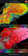
TOR out for a cell near Nortonville, KY:
404
WFUS53 KPAH 110112
TORPAH
KYC107-149-177-110200-
/O.NEW.KPAH.TO.W.0030.211211T0112Z-211211T0200Z/
BULLETIN - EAS ACTIVATION REQUESTED
Tornado Warning
National Weather Service Paducah KY
712 PM CST Fri Dec 10 2021
The National Weather Service in Paducah has issued a
* Tornado Warning for...
Northwestern Muhlenberg County in south central Kentucky...
Southeastern McLean County in northwestern Kentucky...
Southeastern Hopkins County in northwestern Kentucky...
* Until 800 PM CST.
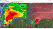
* At 712 PM CST, a severe thunderstorm capable of producing a tornado
was located near Nortonville, or 7 miles east of Dawson Springs,
moving northeast at 45 mph.
HAZARD...Tornado.
SOURCE...Radar indicated rotation.
IMPACT...Flying debris will be dangerous to those caught without
shelter. Mobile homes will be damaged or destroyed.
Damage to roofs, windows, and vehicles will occur. Tree
damage is likely.
* This dangerous storm will be near...
Madisonville, Earlington, Nortonville and Mortons Gap around 720
PM CST.
Other locations in the path of this tornadic thunderstorm include
Graham, Powderly, Greenville and Central City.
This includes the following highways...
Interstate 69 in Kentucky between Mile Markers 95 and 112.
Western Kentucky Parkway between Mile Markers 39 and 59.
Pennyrile Parkway between Mile Markers 29 and 34.
PRECAUTIONARY/PREPAREDNESS ACTIONS...
TAKE COVER NOW! Move to a basement or an interior room on the lowest
floor of a sturdy building. Avoid windows. If you are outdoors, in a
mobile home, or in a vehicle, move to the closest substantial shelter
and protect yourself from flying debris.
Tornadoes are extremely difficult to see and confirm at night. Do not
wait to see or hear the tornado. TAKE COVER NOW!
&&
LAT...LON 3722 8704 3715 8733 3716 8733 3715 8736
3714 8736 3713 8740 3713 8749 3710 8752
3714 8762 3720 8765 3748 8716 3737 8711
3734 8714 3732 8712 3733 8710
TIME...MOT...LOC 0112Z 238DEG 39KT 3717 8755
TORNADO...RADAR INDICATED
MAX HAIL SIZE...<.75 IN
$$
SP