Austin Dawg
Member
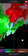
The cell back over west of Little Rock looks like it's getting its act together.
Follow along with the video below to see how to install our site as a web app on your home screen.
Note: This feature may not be available in some browsers.
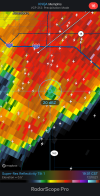
That line of tornado warnings west of St. Louis is crazyFrom a TOR in MO. Note the emphasis that I added:
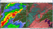
Needless to say, we've got some fast movers here tonight!
Jonesboro cell just ramped up. Winds went from 70 to 140

349
WWUS54 KMEG 110056
SVSMEG
Severe Weather Statement
National Weather Service Memphis TN
656 PM CST Fri Dec 10 2021
ARC031-055-093-111-110130-
/O.CON.KMEG.TO.W.0060.000000T0000Z-211211T0130Z/
Greene AR-Craighead AR-Poinsett AR-Mississippi AR-
656 PM CST Fri Dec 10 2021
...A TORNADO WARNING REMAINS IN EFFECT UNTIL 730 PM CST FOR SOUTH
CENTRAL GREENE...CRAIGHEAD...NORTH CENTRAL POINSETT AND WESTERN
MISSISSIPPI COUNTIES...
At 655 PM CST, a confirmed large and extremely dangerous tornado was
located near Greenfield, or near Jonesboro, moving northeast at 60
mph.
This is a PARTICULARLY DANGEROUS SITUATION. TAKE COVER NOW!
HAZARD...Damaging tornado.
SOURCE...Weather spotters confirmed tornado.
IMPACT...You are in a life-threatening situation. Flying debris may
be deadly to those caught without shelter. Mobile homes
will be destroyed. Considerable damage to homes,
businesses, and vehicles is likely and complete destruction
is possible.
The tornado will be near...
Trumann and Bay around 705 PM CST.
Lake City and Brookland around 710 PM CST.
Monette and Caraway around 720 PM CST.
Other locations impacted by this tornadic thunderstorm include
Hergett, Apt, Vail, Valley View, Macey, Schug, Gum Point, Farrville,
Lester and Mandalay.
PRECAUTIONARY/PREPAREDNESS ACTIONS...
To repeat, a large, extremely dangerous and potentially deadly
tornado is on the ground. To protect your life, TAKE COVER NOW! Move
to a storm shelter or an interior room on the lowest floor of a
sturdy building. Avoid windows. If you are outdoors, in a mobile
home, or in a vehicle, move to the closest substantial shelter and
protect yourself from flying debris.
Tornadoes are extremely difficult to see and confirm at night. Do not
wait to see or hear the tornado. TAKE COVER NOW!
&&
LAT...LON 3561 9074 3580 9090 3609 9045 3575 9019
TIME...MOT...LOC 0055Z 244DEG 50KT 3573 9070
TORNADO...OBSERVED
TORNADO DAMAGE THREAT...CONSIDERABLE
MAX HAIL SIZE...1.00 IN
$$
SMW