
Navigation
Install the app
How to install the app on iOS
Follow along with the video below to see how to install our site as a web app on your home screen.
Note: This feature may not be available in some browsers.
More options
-
Welcome to TalkWeather! We see you lurking around TalkWeather! Take the extra step and join us today to view attachments, see less ads and maybe even join the discussion. CLICK TO JOIN TALKWEATHER
You are using an out of date browser. It may not display this or other websites correctly.
You should upgrade or use an alternative browser.
You should upgrade or use an alternative browser.
Severe WX December 10 & 11, 2021 Severe Threat
- Thread starter Richardjacks
- Start date
That tornado that just crossed into the Bootheel is an absolute monster.
TornadoFan
Member
Good god.Geez!
TH2002
Member
- Messages
- 4,974
- Reaction score
- 11,116
- Location
- California, United States
- Special Affiliations
- SKYWARN® Volunteer

Unbelievable...
warneagle
Member
Could actually end up hitting four states if it holds together that far (which there's nothing stopping it right now).I'm thinking if this holds together we could have another Tri-State Tornado.
OHWX97
Member
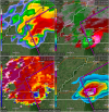
That TDS is massive.

CheeselandSkies
Member
Previous MD from SPC sounds like they expect additional activity further west in AR to eventually ramp up.
Storm Prediction Center Mesoscale Discussion 1991
Severe weather, tornado, thunderstorm, fire weather, storm report, tornado watch, severe thunderstorm watch, mesoscale discussion, convective outlook products from the Storm Prediction Center.
www.spc.noaa.gov
akt1985
Member
Quad-State tornado if it’s still on the ground when it moves into southwestern Kentucky.I'm thinking if this holds together we could have another Tri-State Tornado.
warneagle
Member
That's one of the biggest debris signatures I've ever seen.
warneagle
Member
Did you see that LZK sounding? 2000 J/kg CAPE with almost 400 m2/s2 SRH at 0z. We're just getting started.Previous MD from SPC sounds like they expect additional activity further west in AR to eventually ramp up.
Storm Prediction Center Mesoscale Discussion 1991
Severe weather, tornado, thunderstorm, fire weather, storm report, tornado watch, severe thunderstorm watch, mesoscale discussion, convective outlook products from the Storm Prediction Center.www.spc.noaa.gov
That's one of the biggest debris signatures I've ever seen.
Was about to post that, and it is visible extremely high up in the storm as well. Isn't there a chart based on how high up debris are lofted that correlates really well with the strength of the tornado?
- Moderator
- #313
St. Louis tornado south of radar.
warneagle
Member
NWS St. Louis is taking shelter.
Chris3024
Member
Debris being lofted to 20,000ft
Peter Griffin
Member
[emoji15]

Sent from my Pixel 6 Pro using Tapatalk
Sent from my Pixel 6 Pro using Tapatalk
- Moderator
- #318
It's there.NWS St. Louis is taking shelter.
TornadoFan
Member
Heard a nursing home in Monette, AR took a hit.
akt1985
Member
Will Dyersburg, Tennessee take a direct hit?