• Welcome to TalkWeather!
    We see you lurking around TalkWeather! Take the extra step and join us today to view attachments, see less ads and maybe even join the discussion.
    CLICK TO JOIN TALKWEATHER

Severe WX April 22-24th, 2020 Severe Weather Threat

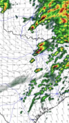
The HRRR doesn’t lend much confidence in anything significant with the morning round outside the very southern flank of the morning convection. Also has the look of some backbuilding over the Central Gulf Coast inhibiting recovery behind the morning round.
 
Just bad...DFW Metro between 4-5, if things come together. Hoping they don’t.
 

Attachments

  • D2219A52-F19A-4378-AB3F-F5030C0720B1.png
    D2219A52-F19A-4378-AB3F-F5030C0720B1.png
    4.2 MB · Views: 0
Main event is likely starting with those cells to the south of OKC. Could be real trouble if things unzip all the way down to the DFW metroplex.
 
Brett has one of the OK tornados on camera

 
I love watching these chaser live videos so I guess I'm part of the problem.
Some of these chasers are driving like total irresponsible idiots and if I were on duty as a Trooper I'd nail 'em.
Tailgating semis on the Interstate, passing on double yellow lines, ignoring traffic signs all while it's raining cats and dogs with limited visibility.

I don't mean to sound like a jerk, I just don't want anymore chasers hurt or killed needlessly.
 
Last edited:
Wow, a regular old localized outbreak happening in south-central and southeast Oklahoma. This is reminding me how badly there needs to be another NEXRAD site along and a little east of the I-35 corridor about midway between KFWS and KTLX. Madill storm doesn't look that impressive, and no clear-cut CC drop. Northernmost tornado warned storm just south of Ada looks the most impressive in terms of velocity.TLX_2203.png
 
Back
Top