cg9450
Member

Ain’t done in TN yet
Follow along with the video below to see how to install our site as a web app on your home screen.
Note: This feature may not be available in some browsers.

I’m concerned about Saturday. Large area of Houston could be under the gun.South Arkansas looks real nasty on the HRRR for this evening. Along 3 days ahead. View attachment 38819
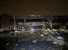
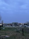
Tennessee was absolutely raked last night. Was awful to see.Good lord I just woke up... far worse than I could've imagined.
Hearing word 9 fatalities thus far there that’s bout 35 miles south meReally concerned about the Selmar, TN are too. That storm looked devastating on radar.
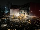
Actually selmer was hit twice Good friend co worker he is a volunteer fireman there. . Said there still on search rescue mission. This morning. People r still missingHearing word 9 fatalities thus far there that’s bout 35 miles south me
I don’t recall a second direct hit on Selmer last night based on radar imagery. I’d be surprised if that’s true.Actually selmer was hit twice Good friend co worker he is a volunteer fireman there. . Said there still on search rescue mission. This morning. People r still missing
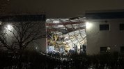
Could it have been a satilite tornado?I don’t recall a second direct hit on Selmer last night based on radar imagery. I’d be surprised if that’s true.
For sure. At first I was, like many others, a bit unsure on how this would unfold, but sure enough once everything kicked into gear it was a complete tornado madhouse.Broyles deserves a gosh darn medal of honor for that forecast or whatever medal he can get. He was pretty much spot on with the high risk placement from the very start. Absolutely brilliant forecast, I really want to personally ask him what his thought process was during that forecast because I don't think anyone could've come close to nailing that in the way he did.
Broyles literally outlined the risk perfectly. This was honestly one of the best forecasts I've seen honestly.Broyles deserves a gosh darn medal of honor for that forecast or whatever medal he can get. He was pretty much spot on with the high risk placement from the very start. Absolutely brilliant forecast, I really want to personally ask him what his thought process was during that forecast because I don't think anyone could've come close to nailing that in the way he did.
it’s wild to think yesterday could have been orders of magnitude worse.Broyles deserves a gosh darn medal of honor for that forecast or whatever medal he can get. He was pretty much spot on with the high risk placement from the very start. Absolutely brilliant forecast, I really want to personally ask him what his thought process was during that forecast because I don't think anyone could've come close to nailing that in the way he did.
Im seeing reports of this happening tooI don’t recall a second direct hit on Selmer last night based on radar imagery. I’d be surprised if that’s true.