Chris3024
Member
The Whiteville, TN has lowering on camera
Follow along with the video below to see how to install our site as a web app on your home screen.
Note: This feature may not be available in some browsers.
I was going to say that looks an awful lot like Houston/New Wren 2011...That looks violent.
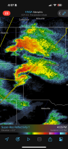
Terrible timing for this look..View attachment 38505
I can't imagine how this thing will look once it actually touches down.
It’s giving me Amory, MS vibes.View attachment 38511I think it’s time.
Can we add locations or towns on radar shots? There's a lot of cells right now and this is kind've inscrutable with no labelsView attachment 38511I think it’s time.
St. Louis storm?It’s giving me Amory, MS vibes.
I'm gonna guess they haven't gotten to the worst damage yet?Surprisingly, the Nevada, MO tornado from this morning was only rated EF-1, 98 mph max winds.
Apologies. This is the Missouri storm.Can we add locations or towns on radar shots? There's a lot of cells right now and this is kind've inscrutable with no labels
Preliminary PNS, so maybe, but looked pretty thorough. Anyway, I realize now is not the time, be lots of surveys to debate another day I’m afraid.I'm gonna guess they haven't gotten to the worst damage yet?

I hope you're right.I don’t want to be that guy, but the area around KNQA in Memphis and to the south is getting increasingly cramped by additional convection. You have to wonder if those storms will merge and line out before any of them even sniff the favorable lower LCLs up north