
- Thread starter
- #101
Bulkshear
Member
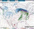
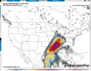
EHI 7 Extreme tornado potential ( Upper Echelon)
Bulk shear 60 kt Long-lived supercells
500mb jet 60-65 kt Strong upper support
Dew point 65°F Sufficient moisture
South wind at surface SW wind at 850mb Strong directional shear
700-500mb lapse rate 7.5°C/km This is Very Steep, enhancing storm strength
CAPE = 2500 J/kg Sufficient Strong instability
850mb SW winds at 60kt Powerful low-level jet (critical for violent tornadoes)
Surface-based LI -8 is absolutely Explosive Instability
0-3 km SRH = 450-500 Outbreak-level tornado potential
Numbers like this could be a generational tornado event if it verifies. These were pulled off the latest GFS
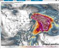

.jpeg")
