
Navigation
Install the app
How to install the app on iOS
Follow along with the video below to see how to install our site as a web app on your home screen.
Note: This feature may not be available in some browsers.
More options
-
Welcome to TalkWeather! We see you lurking around TalkWeather! Take the extra step and join us today to view attachments, see less ads and maybe even join the discussion. CLICK TO JOIN TALKWEATHER
You are using an out of date browser. It may not display this or other websites correctly.
You should upgrade or use an alternative browser.
You should upgrade or use an alternative browser.
Severe WX April 1-2 (overnight) Severe Weather Event
- Thread starter Bulkshear
- Start date

jiharris0220
Member
Hold on now, the SPC is more than aware and definitely more so aware of any failure modes than what Trey sees.He sees the flies in the ointment sometimes more then SPC.
It’s just because the SPC is a government body and focuses more on public awareness of severe weather. Which means they have to follow a more strict standard of weather forecasting.
If the models shows a high risk worthy environment (as in widespread convective coverage capable of producing significant tornadoes) then the SPC pretty much have no choice but to issue a high risk.
Even though personal opinions of the individual people who work for the SPC may differ substantially.
Kds86z
Member
Makes sense. True.Hold on now, the SPC is more than aware and definitely more so aware of any failure modes than what Trey sees.
It’s just because the SPC is a government body and focuses more on public awareness of severe weather. Which means they have to follow a more strict standard of weather forecasting.
If the models shows a high risk worthy environment (as in widespread convective coverage capable of producing significant tornadoes) then the SPC pretty much have no choice but to issue a high risk.
Even though the personal opinions of the individual people who work for the SPC may differ substantially.
Keldeo
Member
Kds86z
Member
They did a dang good job today @jiharris0220Hold on now, the SPC is more than aware and definitely more so aware of any failure modes than what Trey sees.
It’s just because the SPC is a government body and focuses more on public awareness of severe weather. Which means they have to follow a more strict standard of weather forecasting.
If the models shows a high risk worthy environment (as in widespread convective coverage capable of producing significant tornadoes) then the SPC pretty much have no choice but to issue a high risk.
Even though the personal opinions of the individual people who work for the SPC may differ substantially.
tennessee storm chaser
Member
- Messages
- 1,877
- Reaction score
- 4,283
- Location
- jackson tennessee
- Special Affiliations
- SKYWARN® Volunteer
Looks like a rough ride for west Kentucky and west Tennessee coming later
tennessee storm chaser
Member
- Messages
- 1,877
- Reaction score
- 4,283
- Location
- jackson tennessee
- Special Affiliations
- SKYWARN® Volunteer
Atmosphere is a keg of dynamite in that areaI honestly don’t agree with the high risk, the potential is there, but I’m not sure what they’re seeing that makes them confident enough to issue such a thing.
Obviously they’re the experts but the failure modes for this are obvious.
Guess we’ll see how it plays out, and again, I don’t disagree that the potential is there, I just don’t know where this confidence stems from.
Kds86z
Member
AJS
Member
Waking up to a high risk issued was not on my 2025 bingo card.
AJS
Member
The last thing they need is a train of supercells barraging down in that area.I’d take it with some grain of salt. But it does have multiple areas from the western Kentucky tornado getting a supercell train.
Todd
Member
People should consider that many individuals will be at work and children in school as the severe storms move eastward today.
CheeselandSkies
Member
HRRR and 3KM NAM remain on different planets with regards to afternoon supercell potential over northern Illinois. How annoying. Back to bed with me.
Tomcats Forever!
Member
My memory's a bit fuzzy this morning. First high risk in Kentucky since March 2012?
tennessee storm chaser
Member
- Messages
- 1,877
- Reaction score
- 4,283
- Location
- jackson tennessee
- Special Affiliations
- SKYWARN® Volunteer
Have not seen a afd written by Memphis Nws like this morning. I. Years
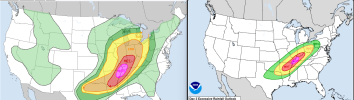
Although yesterday the forecast always seemed more uncertain, and in fact the risk of multiple stronger tornadoes seemed quite low (the post I wrote last night explained some of the reasoning of why), today has the potential to be very dangerous. Honestly, I think the SPC High Risk has quite a chance of verifying, unfortunately.
The setup is very synoptically evident. The trough is strong, long and high amplitude with an exceptionally powerful and fast moving 110kt+ speed max ejecting into the upper Midwest through the early afternoon. It’s my suspicion that the SPC tends to favour events where the synoptics are more impressive, which as some of the discussion following the 3/14-3/15 outbreak alluded to, means you essentially need fewer things to “go wrong” to get a widespread tornado event. Chris Broyles led a lot of the research into fast ejecting jet streaks and their correlation with tornado outbreaks (and as we all know he was the D1 forecaster on the desk this morning)
There is high confidence on a parameter space supportive of EF2-3+ tornadoes. Some of the models vary on the extent of this, for example the NAM is more supportive of a higher end and more widespread environment than the HRRR, but fundamentally with such a large rich warm sector and strong low-level jet any supercell you get is likely to be tornadic.
The main uncertainty lies in how the current convection in Oklahoma develops. Models have already backed off a bit from what was originally this line continuing all the way into the afternoon and completely disrupting the warm sector. Now almost all CAMs show a progressive weakening and slowing of the line as it progresses eastward, resulting in a weaker moist baroclinic zone positioned from MO into AR around 16-18z. This makes sense given it’s moving into a zone of subtle height rises, as well as a strong cap with prominent mid-level dry air (which was observed to be quite widespread on 00z soundings)
The most dangerous scenario is your RRFS, NAM type scenario – this baroclinic zone remains fairly quiet, but eventually produces bands of supercells in the MDT/HIGH risk corridor which as the environment becomes more favourable with time, will produce intense tornadoes. This is what the SPC is presumably expecting, and I think given a potentially stronger cap than forecast, and the inevitable last-minute CAPE increases which seem common nowadays (for whatever reason) is perhaps more likely at the minute. Given the strong upper-level winds, and long warm sector, I am concerned about the possibility of multiple powerful, long tracked, tornadic supercells even into the evening. Especially from TN/KY into IN/IL.
The HRRR scenario is that this band redevelops into a messy squall line, with very strong winds and embedded tornadoes all the way from AR into IN/OH. This scenario still brings widespread severe but is not 5/5 worthy. However, I have gone and looked at some past MS valley event’s HRRR runs, and the HRRR seemed to tend to produce similar squally, messy lines of storms. In this case, both the LLJ and upper level winds are so strong, and without the warm sector being uncapped, I somewhat struggle to imagine. Hopefully I am wrong.
Either way, dangerous day ahead – populated area with a possible nocturnal mode. When CAMS are so split its probably best to look more at obvs and the broader pattern especially as we get closer in time. Will be interesting to see how everything evolves through the day. Take care everyone.
AJS
Member
Excellent analysis as usual my man!Although yesterday the forecast always seemed more uncertain, and in fact the risk of multiple stronger tornadoes seemed quite low (the post I wrote last night explained some of the reasoning of why), today has the potential to be very dangerous. Honestly, I think the SPC High Risk has quite a chance of verifying, unfortunately.
The setup is very synoptically evident. The trough is strong, long and high amplitude with an exceptionally powerful and fast moving 110kt+ speed max ejecting into the upper Midwest through the early afternoon. It’s my suspicion that the SPC tends to favour events where the synoptics are more impressive, which as some of the discussion following the 3/14-3/15 outbreak alluded to, means you essentially need fewer things to “go wrong” to get a widespread tornado event. Chris Broyles led a lot of the research into fast ejecting jet streaks and their correlation with tornado outbreaks (and as we all know he was the D1 forecaster on the desk this morning)
There is high confidence on a parameter space supportive of EF2-3+ tornadoes. Some of the models vary on the extent of this, for example the NAM is more supportive of a higher end and more widespread environment than the HRRR, but fundamentally with such a large rich warm sector and strong low-level jet any supercell you get is likely to be tornadic.
The main uncertainty lies in how the current convection in Oklahoma develops. Models have already backed off a bit from what was originally this line continuing all the way into the afternoon and completely disrupting the warm sector. Now almost all CAMs show a progressive weakening and slowing of the line as it progresses eastward, resulting in a weaker moist baroclinic zone positioned from MO into AR around 16-18z. This makes sense given it’s moving into a zone of subtle height rises, as well as a strong cap with prominent mid-level dry air (which was observed to be quite widespread on 00z soundings)
The most dangerous scenario is your RRFS, NAM type scenario – this baroclinic zone remains fairly quiet, but eventually produces bands of supercells in the MDT/HIGH risk corridor which as the environment becomes more favourable with time, will produce intense tornadoes. This is what the SPC is presumably expecting, and I think given a potentially stronger cap than forecast, and the inevitable last-minute CAPE increases which seem common nowadays (for whatever reason) is perhaps more likely at the minute. Given the strong upper-level winds, and long warm sector, I am concerned about the possibility of multiple powerful, long tracked, tornadic supercells even into the evening. Especially from TN/KY into IN/IL.
The HRRR scenario is that this band redevelops into a messy squall line, with very strong winds and embedded tornadoes all the way from AR into IN/OH. This scenario still brings widespread severe but is not 5/5 worthy. However, I have gone and looked at some past MS valley event’s HRRR runs, and the HRRR seemed to tend to produce similar squally, messy lines of storms. In this case, both the LLJ and upper level winds are so strong, and without the warm sector being uncapped, I somewhat struggle to imagine. Hopefully I am wrong.
Either way, dangerous day ahead – populated area with a possible nocturnal mode. When CAMS are so split its probably best to look more at obvs and the broader pattern especially as we get closer in time. Will be interesting to see how everything evolves through the day. Take care everyone.
High risk???? Whatttt