981
WTPZ42 KNHC 242051
TCDEP2

Hurricane Polo Discussion Number  17
NWS National Hurricane Center Miami FL       EP172026
300 PM CST Thu Sep 24 2026

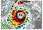
A NOAA Hurricane Hunter aircraft has investigated Polo during the
past few hours, and its data indicates that the eyewall replacement
cycle mentioned in the previous advisory is almost complete. The
first aircraft pass reported concentric eyewalls of 15 and 30 n mi
diameters. Subsequent passes reported that the inner eyewall
dissipated, while the remaining outer eyewall contracted to 25 n mi
diameter. In addition, 700-mb flight level winds in the northeast
eyewall increased by about 15 kt during the mission, with the
maximum winds of 147 kt.  The central pressure also started to fall
during the mission, and the estimated value from data on the last
pass is near 935 mb. Based on these data, the initial intensity is
set at 130 kt. It should be noted that the strengthening observed
by the aircraft has not yet been fully reflected in satellite
imagery.

Polo is now moving west-northwestward or 285/9 kt. There is little
change to the track forecast reasoning from the previous advisory.
A mid-level ridge building westward from northern Mexico should
steer the hurricane generally westward for the next 24-36 h or so.
After that, a mid-latitude trough moving eastward across the
northeastern Pacific should prevent the ridge from building farther
west, with Polo likely to recurve northward and northeastward
around the western end of the ridge. The track guidance is
generally in good agreement with this scenario, although there
remains some spread in the forward speed between the slower HAFS
models and the faster GFS and HCCA models. The new track, which is
an update of the previous forecast, takes the center away from the
southwestern coast of Mexico this evening and then has it moving
across Baja California into northwestern mainland Mexico in 96-120
h.

The new intensity forecast now calls for Polo to strengthen for the
next 12 h or so after the end of the eyewall replacement, and Polo
is expected to regain Category 5 strength tonight or Friday
morning. After that, a slow weakening is expected through 96 h as
Polo encounters somewhat increased shear, with the caveat that
there could be some fluctuations due to additional eyewall
replacement cycles. Rapid weakening is expected when the cyclone
crosses Baja California and moves into mainland Mexico. The new
forecast again lies near the upper edge of the intensity guidance.

It should be noted that moisture from Hurricane Polo and Odalys
will be carried a long distance into the southwestern United States
this weekend and early next week, and may indirectly contribute to
a heavy rainfall and flash flood threat in the region. See products
issued by the Weather Prediction Center for more information.